Rain Sunday, Storms Possible Monday & Wednesday–a Sweet Forecast

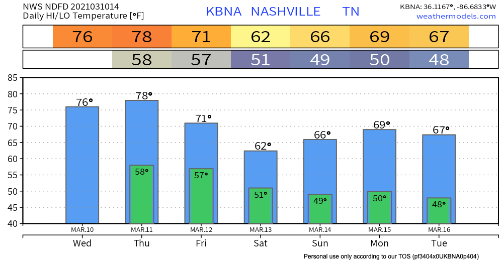
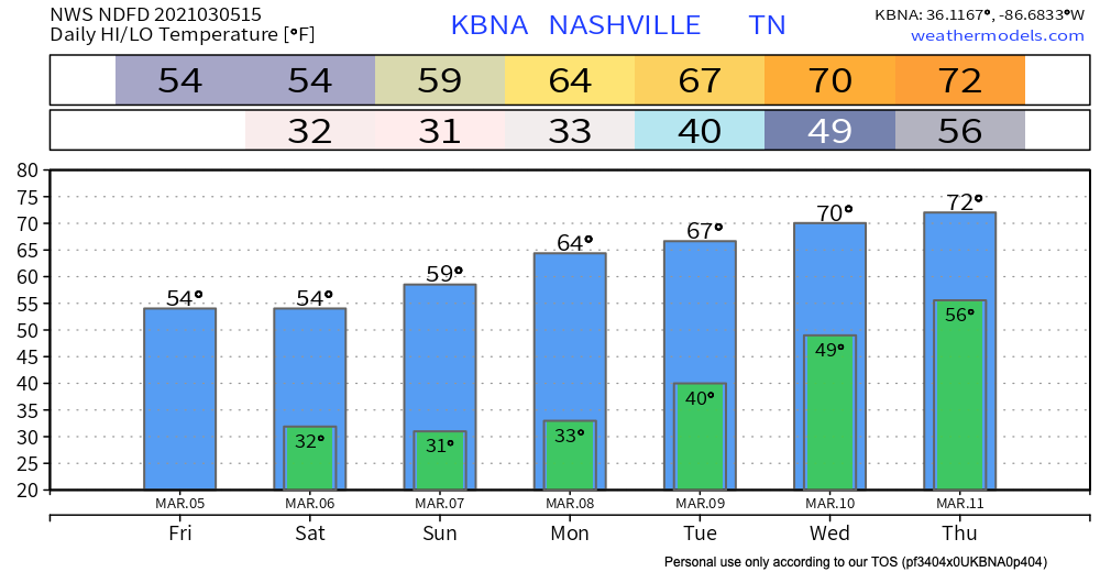
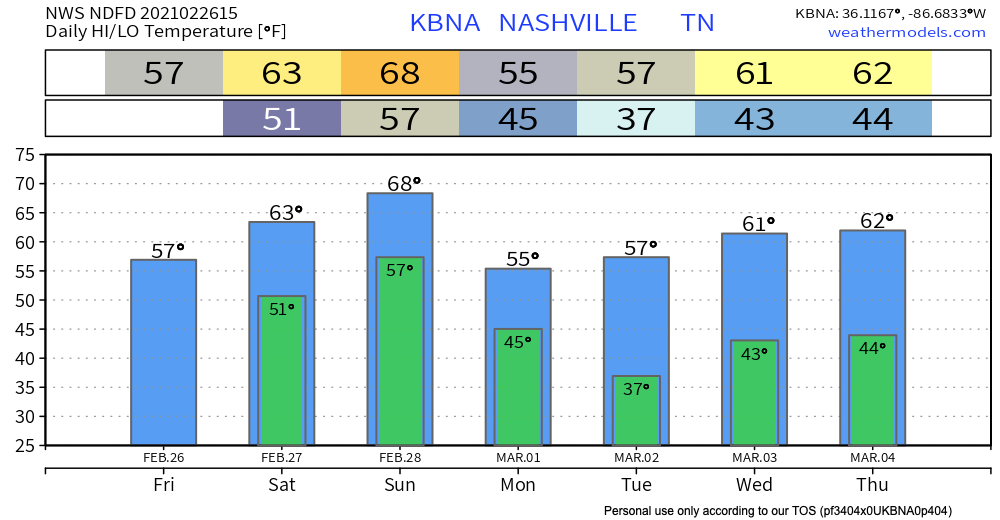
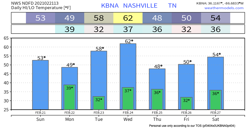
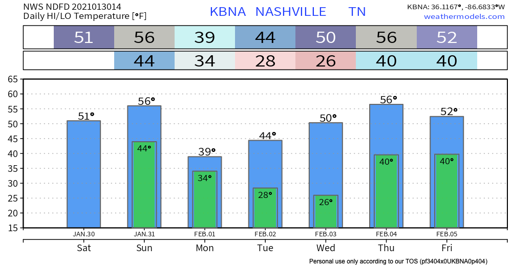
Weather requires lots of math. Lots of math, and lots of pi. In honor of one of the best math-themed holidays, I present to you a pi-themed forecast.

Scattered Showers & Clouds Sunday

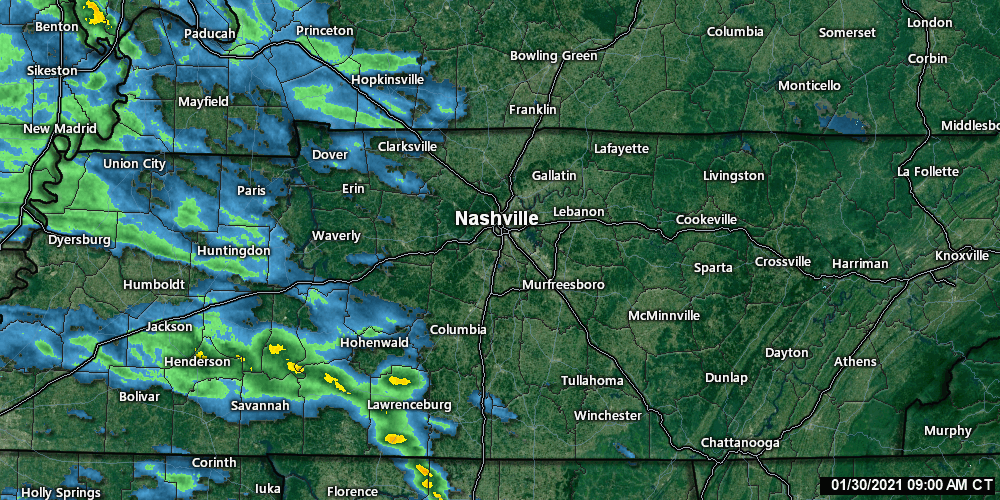
A thin slice of rain showers is moving through Middle Tennessee as seen on radar this morning: read more

Wind, Rain, and Maybe Storms Early Next Week.

Windy & Warm Wednesday

Our temperatures will continue to trend well above average by over 15º.

We can thank a surface high weather regime for these May-like temperatures. The surface high pressure will begin to move off to our northeast by tonight. read more

Betcha Didn’t Know This About March 5th!

5º: the low temperature on this day in 1960

2.9 inches: snow that fell on this day in 2015

1º: the departure from normal (36º) of our low temperature this morning (37º)

80º: the high temperature on this day in 1910 read more

Rain Friday, Rain Saturday, Rain Sunday, Rain Monday.

Rain will continue off and on today through Monday. The greatest possibility for flooding will arrive Sunday night through Monday. Severe weather threats remain minimal. If you have outdoor stuff you NEED to do, Saturday afternoon is your best shot. read more

Melting Continues; Rain on Its Way Overnight to Wash Away Snow Creations.

Enjoy the Sunday Sunshine!

A beautiful day awaits with high temperatures around 50º. Lots of melting will take place. With that being said…

Ice missiles are still a threat. Continue clearing off the tops of your vehicles.

Keep an eye on your ceiling. There might still be ice in your gutters blocking the water’s path off your roof. The only way for it to go is down… into your house. Clear your gutters of ice if you can. read more

Winter Storm Warning Wednesday–Thursday: Timing, Impacts, Other Details

More Snow Beginning This Afternoon

Road conditions are still extremely hazardous across Middle Tennessee.

Enjoy the sun this morning but don’t expect anything to melt. High temperatures will be hard pressed to make it above freezing. Anything that falls today and tomorrow will sit on top of this stubborn layer of ice. read more

Watching Several Winter Weather Events Over the Next 7 Days

Beware of Freezing Fog/Drizzle This Morning

Bridges, overpasses, and elevated surfaces may be slick.

There is a lot of elevation variation throughout Williamson and Davidson counties, so it’s hard to say if your street specifically will have black ice. The safe thing is to assume that your street has slick spots. Then maybe you will be pleasantly surprised. read more

Very Cold Today, Few Rain/Snow Chances This Week

Splat:Melt (except at elevation)

Those atop hills may have woken up to a treat in the form of white frozen stuff. Maybe enough to break out your sled. But that’s probably a bit of a stretch.

Big flakes fell while most of us slept. Most of us were too warm, too low in elevation, for it to stick. read more

Rain Today Kicks off Very Active Weather Pattern Over the Next Week

Rain Heading Our Way Today

According to the HRRR, scattered showers may begin moving through as early as noon. More substantial rain will develop later this afternoon/tonight. Timing for that looks to be around 4pm. Everything should be gone just before midnight. read more

Will Winter Finally Make Its Presence Known With Groundhog Day Approaching?

Rain Chances Today

Radar from 9:40 CST shows precipitation sitting just off to our west. 

Radar is constantly updating, so for the most recent run visit https://nashvillesevereweather.com/radar/.

Once again, dry air near the surface will gobble up precipitation before it reaches the ground. See the large dry air slot (space between the red and green lines on the sounding) between the surface and 700mb? Yeah, you can thank the Dry Air Monster for that. read more