
Heat Approaching Dangerous Levels Today
The heat arrives in full force today. It will be compounded by full sun and no chance for rain.
Lucky for us, the humidity will begin to build after the peak daytime heating. The heat index will just miss 100º. Notice below how the most humid air (in brown) is stuck just to our west.
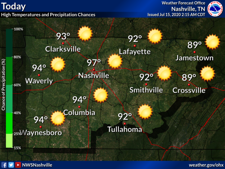
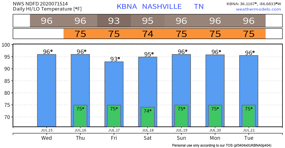
Today will be the “good” kind of 96º temps.
We aren’t even close to the record high for Nashville on July 15 (103º, set in 1980) but these dogs have the right idea.

Then Comes the Bad 96º….
What makes it bad?
Thursday:
Dewpoints Wednesday in the 60s will rise into the low 70’s Thursday morning, then stay there through the weekend.
Add oppressive humidity to that a high of 96º, and the temp/dewpoint combo will create heat index temperatures up to 104º in the afternoon.
Editor’s Joke: You could send your fish to check your mail if only your goldfish had thumbs.
The only relief from this heat will come from an afternoon storm or two. And oh by the way, Thursday storms may be strong, even severe:
Diurnal heat can cause showers and storms to develop. There is some instability around the area, and the deep layer shear is strong enough for some organized convection to be strong to severe in the northwest on Thursday.
-NWS Area Forecast Discussion
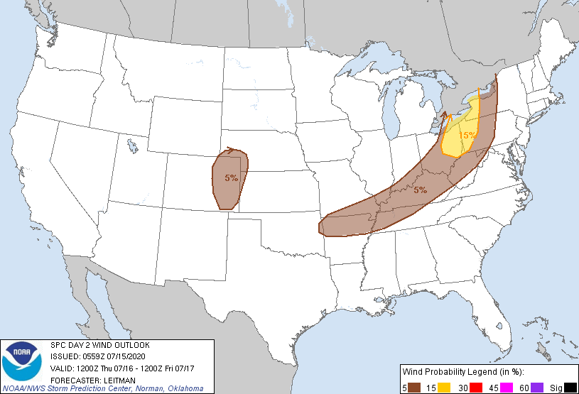
The Storm Prediction Center has included Nashville in its damaging wind outlook for tomorrow. There is a 5% chance of damaging thunderstorm winds within 25 miles of you.
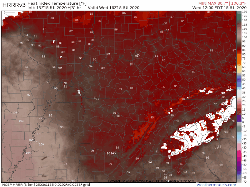
We will keep our eyes out for any updates to the storm outlooks for Thursday as models hone in on locations and timing. Below is the HRRR model. It covers Thursday afternoon and thinks a line of storms will stretch across the area, but then weaken and dissolve before they get here.
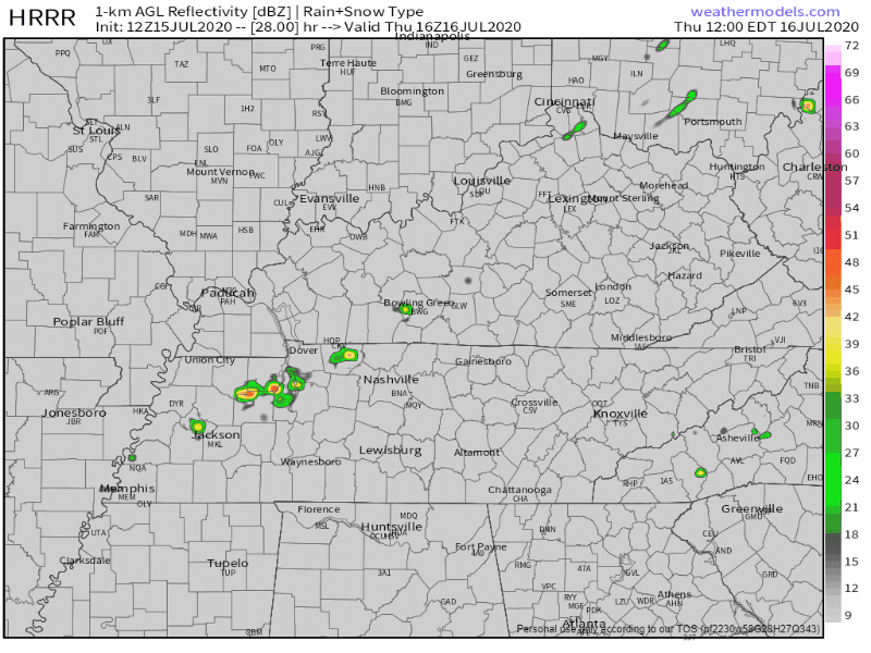
I would not “bet” on this model run. We’ll tweet more about this tonight.
Thursday afternoon rain could be good news for both heat relief and for the garden you are trying to keep alive.
Editor’s Note: one of two things are likely Thursday — dangerous afternoon heat/humidity rendering outdoor activities a heat exhaustion or heat stroke risk, or a storm coming in with briefly heavy rain, lightning, with a potential for damaging winds.
Friday & Into the Weekend:
We may catch a bit of relief from the 100º+ heat index on Friday. Some cloud cover in the morning, followed by higher rain chances in the afternoon, might tame the heat a little bit. This pattern will stick around into Saturday, too.
That’s not to say it won’t be hot. We will have mid/upper 90s temps with the dewpoint in the low 70ºs. Afternoon-dangerous heat exhaustion/stroke conditions with heat indexes in the 100º to 105º range are expected at least through the weekend. Cloud cover and afternoon storms are the only cool-down hope. Expect several showers and storms to pop up each afternoon, but exactly where, no one knows.
Plan outdoor activities for the mornings.
Heat stroke is the leading cause of …
. . . vehicular, non-crash related deaths in children under 15.
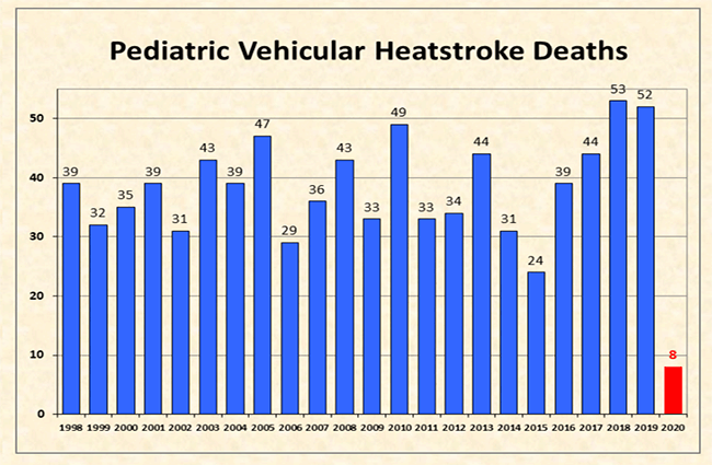
A child’s body heats up three to five times faster than an adult’s body. Heatstroke in children begins when their core body temperature reaches 104º. When their body reaches 107º, the effects of heat can be lethal. On a day like today, that could happen in minutes.
Always remember to check the backseat before leaving your vehicle!
Also note that kids’ bodies do not cool off the way an adult’s body does regardless of whether they’re in a car. So what seems to be somewhat intolerable heat to you will be more intolerable to a child.
Categories: Forecast Blogs (Legacy)
You must be logged in to post a comment.