Bad News for Snow Lovers

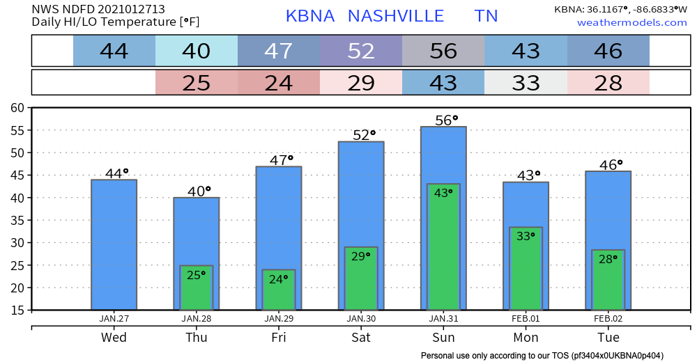
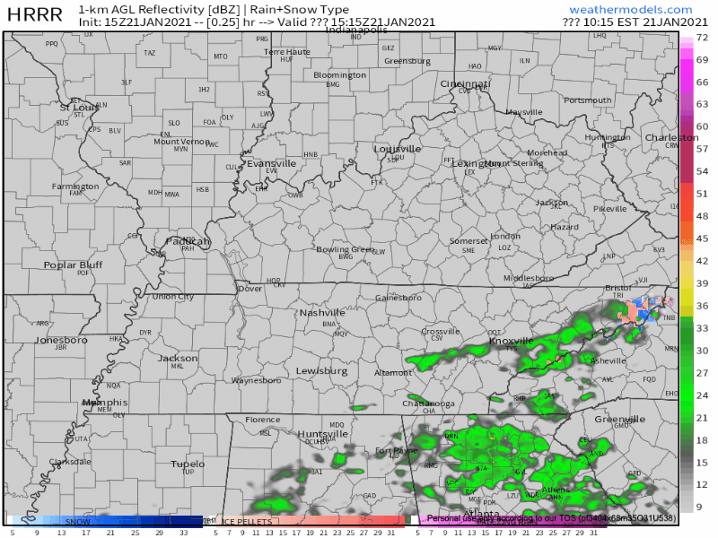
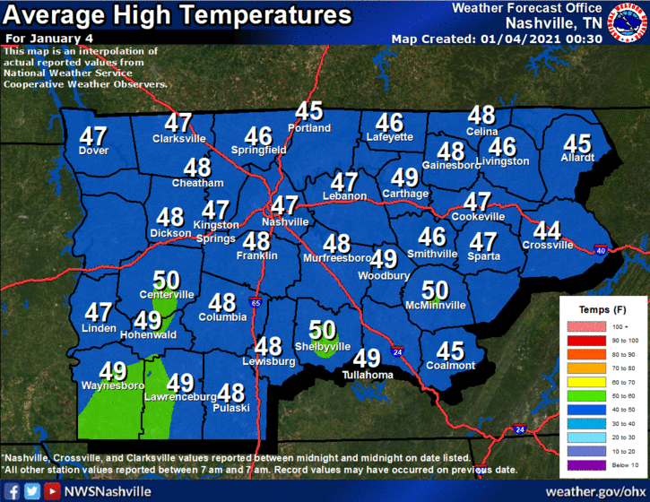
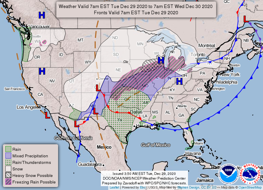
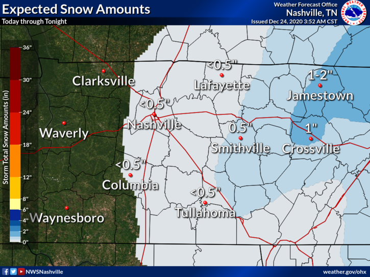
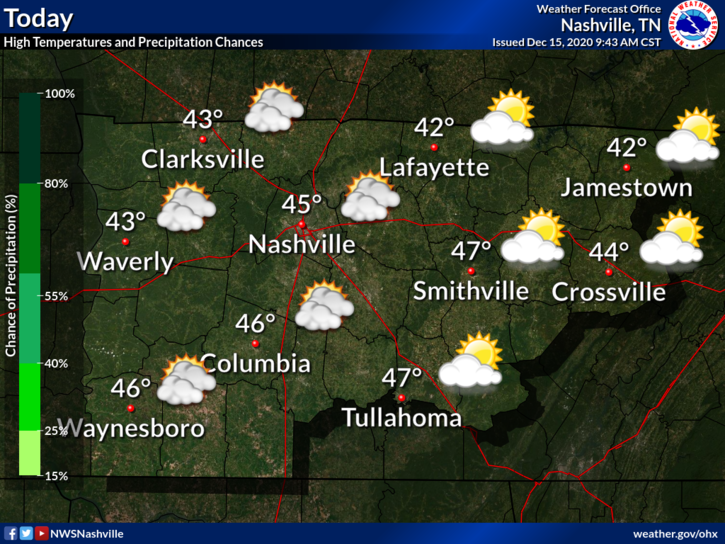
Dry Air Monster Is Hungry Today

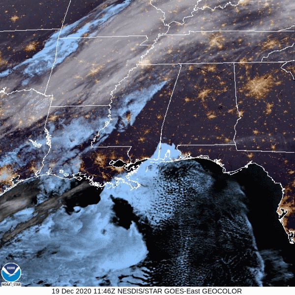
Precipitation is crossing over the Mississippi River as of 10:30am CST:

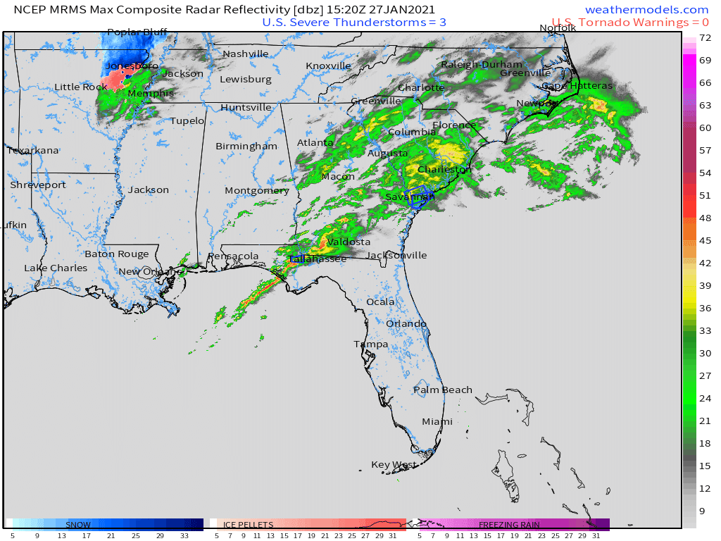
Radar imagery is constantly changing. For the most up to date data, visit https://nashvillesevereweather.com/radar/. The website will refresh every minute with the most current imagery. Also, stay tuned to @NashSevereWx on Twitter for updates (and some humor mixed in)! read more

Low-End Severe Threat & Lots of Rain Expected Monday

Mild & Clear Start to the Weekend

The calm before the storm. Literally.

The fog has cleared up. We may see some lingering clouds today.

An absolutely beautiful day is in store on Saturday. A little chilly, but it’s your chance to get sunshine before Sunday & Monday. read more

Watching Potentially High Rainfall Event Sunday and Monday

Bon Voyage, Rain!

HRRR simulated radar, valid 9am through 1pm Thursday

The rain is sliding off to our southeast. We will have a chance to dry out this afternoon.

Beware of especially cold temperatures Friday night into Saturday morning! We will dip well below freezing into the mid 20’s. read more

Snow Winding Down

Enjoy the Winter Wonderland (if You Can Call It That…)

Pockets of snow dot the radar this morning. It will continue to fall through about noon.

HRRR simulated radar, valid 7am through 1pm Saturday

Snow is sticking to some roads. Be extra cautious if you are driving this morning. Especially bridges and overpasses that may have some frozen patches. read more

Frozen Precipitation Thursday. But, Probably Just Rain.

Sunny Beginning of the Week

Today will be the warmest day in the next seven days ahead. We’re pushing a bit above average. That’ll change starting Tuesday.

Nothing but sunshine these next few days!

Thursday Night Rain/Frozen Precip? It’s All About the Timing of Cold Temperatures

Both the Euro and GFS have rain beginning around noon Thursday moving out of Middle Tennessee by midnight. read more

Rain Probable Thursday.

Sunday: The Beginning of a Quiet Forecast

You may have been graced by a few snowflakes this morning. Those are gone, and the rest of the day should be mostly sunshine.

Tonight, temperatures will dip below freezing, to around 31º.

* * * * read more

Plenty of Rain to Usher in the New Year!

Sunny, with Average Temperatures on Tuesday

Beautiful today, high reaching 50º. This is near climatological norms:

A surface high pressure is just to our north, which will fend off rain for one more day. Tomorrow’s a different story, though. All that “stuff” to our west on the map below will move towards Middle Tennessee. read more

We Discuss the C.O.L.D. (Chance Of Light Dusting)

Flurries Possible This Afternoon

What’s on everybody’s mind, perhaps more than what’s under the Christmas tree.

Model soundings for this afternoon show a very shallow layer of moisture. There is enough lift in the atmosphere to squeeze out a few flakes for us. Our best chances of seeing the white stuff will be after about 3pm. read more

Rain Showers Saturday Night. More Details on Whatever’s Going to Fall Thursday.

Cloudy Saturday, Ending in Rain Overnight

Everyone’s favorite–Saturday rain! Fortunately, today won’t be a washout. High temperatures will reach 47º. Our overnight temperatures will stay relatively mild due to the rain. 

Clouds will increase throughout the day, culminating in rain tonight. read more

Chilly Rain Beginning Tonight with (Maybe?) a Few Inconsequential Flakes Mixed In

Rain Tuesday Night & Wednesday Morning

Bundle up! A cold day awaits. Luckily, we will be sunny today, so that will help our high temperatures reach a ~balmy~ 45º.

Clouds are clearing a bit this morning, but they will build back up this afternoon ahead of our next precipitation event. read more