Rain, Maybe a Strong Storm Tonight

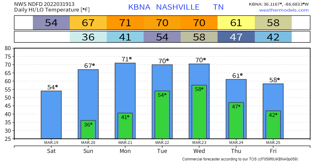
Lotta rain coming in. Some thunderstorms. Severe risk is low, but not zero.

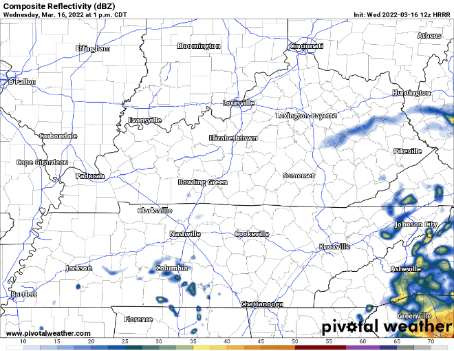
HRRR model below shows showers and storms coming in this evening. Main line is over our area around 9:00 pm. Stay weather aware this afternoon through evening time. These showers and storms should be out of the area by early Wednesday morning with lingering sprinkles up until 12pm Wednesday. HRRR through 6:00 am tomorrow: read more

Heavy Rain Tuesday Night w/ a Flooding Risk

Another beautiful spring day today. Low 70s and sunshine. Clouds increase throughout today ahead of the system that is affecting us tomorrow.

Low pressure sweeps across the southeast tomorrow. Severe weather is not a concern for our area, that concern stays south of us (the legitimate severe thunderstorm and tornado concern will sweep from TX tonight to LA overnight into MS to AL Tuesday). For us nonsevere thunder, downpours, and gusty winds < 30 mph will be what we get. read more

Lots of Rain Tuesday

Happy first day of Spring!

The dry weekend will continue into today. Lots of sun, no rain, temps in the 60’s. Tomorrow is a repeat of today with slightly warmer temps.

Rain returns Tuesday. A powerful storm system to our southwest will move south of us and eventually bring us not severe weather, but heavy rain. read more

Dry Weekend, Next Rain (Storm?) Chance Tuesday

Not much going on today, drizzle will move out by lunch, but the clouds will likely hold on until around sunset. Cooler than average temps.

Sunday stays dry, nice clear day with temps back to around average. Monday is a repeat of this. read more

Grab that ham sammy or lettuce salad and read this during lunch about severe storms maybe getting here later.

WHAT

Tornado, damaging straight line winds, and large hail.

A low probability of a high impact event.

In the form of small, rotating supercells spread widely around the evening. So wide we might not even see rain. read more

Couple of Rounds of Storms Possible Friday, Maybe Severe

Today we’re expecting seasonal temps and a sunny day. It’s a go for all St Patty’s Day celebrations.

Starting tomorrow, we have another rain/storm chance, potentially two rounds. The HRRR shows round one of storms coming through around 8 a.m, and clearing out by noon. This timing may change as we get closer. read more

Wet Today, Dry Tomorrow

We’re on the tail end of the low pressure responsible for the latest rain. Nothing left but a few light showers (mostly south of I-40). Everything should be out by this evening:

HRRR Composite Reflectivity, Wed. 1pm – Wed. 8pm

NWS has backed off of forecasted highs for today… courtesy of cloudy skies. Will get more sun tomorrow as we dry out. Thursday will be more agreeable with your spring break plans. Warm temps and no rain. read more

Rain Returns Tonight - Tomorrow Morning

Low pressure sweeps across the gulf causing our area some showers overnight tonight. HRRR model below has showers coming in right after midnight. These continue until about lunch time Wednesday. Perhaps some sprinkles do hang around Wednesday afternoon. No threats are expected to come with this system. read more

Warm This Week; Light Rain Chance Tuesday Evening

Forecast this week looks a lot different than the cold temps and snow we experienced over the weekend. Temperatures warm up to the mid 70s by Thursday. We stay warm for the rest of the week staying in the 60s. read more

Warmer Temps on the Way; Staying Dry Today

This morning the temps were really cold. Temps in the teens when accounting for wind chill. By the time you’re reading this the temps will have warmed into the mid 50’s. This along with minimal cloud cover will help melt any remaining snow. read more