It’s Still Hot, Higher Chances for Storms This Afternoon

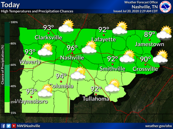
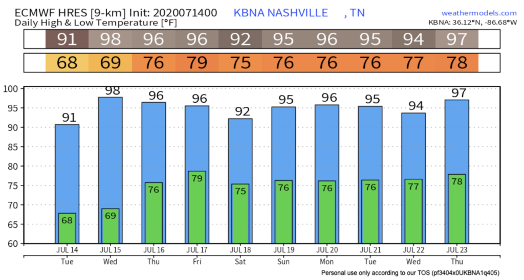
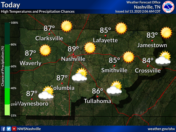
Another typical summertime forecast. It’s miserably hot and humid with high temps today in the mid 90s.

Afternoon storms are bit more likely today. Showers/storms will break out across the region around 1 PM and will come and go. Some storms could contain strong winds and heavy downpours. Will you get one? Who knows, models do not do well predicting the “where,” although they do OK with the “when.” read more

Bringing the Heat Today; A Few Degrees of Relief and Higher Rain Chances Later this Week

A Hot, Potentially Stormy Start to the Week

You know the drill by now: hot and humid today, with a chance for scattered showers this afternoon.

The dewpoint will hover around 71º. As of 11am, the heat index at BNA was already 100º, so I wouldn’t be surprised if we approached a heat index near 105º by this afternoon. If the temp soars, the humidity will come down a bit. But if not, the humidity will stick around. Either way: read more

Heat Advisory Today, Rain/Storms More Likely By Mid-Week

The National Weather service has issued a Heat Advisory from 10 AM to 6 PM. Dew points in the low 70s and temperatures to 98° will send the heat index value as high as 105°. A Heat Index is issued when the NWS thinks the heat index will get to 105°, the level NWS thinks will cause you problems. read more

Extreme Heat For the Weekend

Today we are starting off with sunny skies and temperatures in the low 80’s. As the day matures, you can expect those temperatures to spike once again into the high 90’s.

Oppressive Humidity, Maybe a Passing-Cool-You-Off Shower

Hot and humid weather will be the theme for this blog.

Highs Friday will be around 95 with a heat index in the low 100s. read more

Baking Heat followed by Maybe an Afternoon Thunderstorm, Heat & Humidity Sweat Us into the Weekend

Sticky, low/mid 70 dewpoints will join us now into this afternoon as we continue the trend for hot and humid weather. High temp today will approach 95 but will feel more like 105.

Chance for thunderstorms expected to increase after 1 PM into the evening hours. read more

Not All 96º Days Are The Same: Bad Today, Worse Thursday Through the Weekend. Plan Outdoor Activities for the Morning.

Heat Approaching Dangerous Levels Today

The heat arrives in full force today. It will be compounded by full sun and no chance for rain.

Lucky for us, the humidity will begin to build after the peak daytime heating. The heat index will just miss 100º. Notice below how the most humid air (in brown) is stuck just to our west. read more

Heat Index Values Continue to Climb, Storm Chances Increase Thursday

Temperatures this week continue to climb into the mid – upper 90s with heat index values approaching the 100’s.

,The air today will be slightly drier which won’t send those heat index values soaring into the triple digits until tomorrow. read more

Getting a Break from the Rain, But Dangerously Hot Temps on the Way

Monday

The sun has returned to start the work week.

More Storms Possible Sunday Evening, Hot/Dangerous Heat Indices Mid-Late Week

Busy start to the day already with severe storms and a wake low

Unfortunately, more storms are possible later this evening.

Threats

SPC has the entire area under a 5% chance of seeing severe winds within 25 miles of a point. read more