IDK Who Ordered Two Glorious Cold Fronts But Here They Come and We Are Here For It

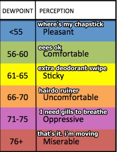
The dewpoint was over 70 this morning.
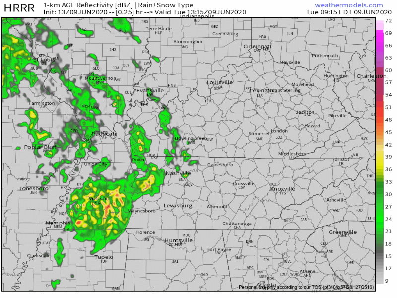
Low Potential for Severe Weather Today, Low Storm Chances Wednesday, Then Sunny

Today

Overcast skies are the current conditions we are seeing for now at 77 degrees.

As the day continues, the threat for severe weather continues as well.

Storms Monday PM and Tuesday, Drier and Cooler Weather to End the Week

Monday

Skies will be mostly cloudy today. Although stronger storms should remain to our southwest, we can’t rule out a stray storm ending up in your backyard. Because of Cristobal’s location to our west, wind speeds will increase. There will be a 10 to 15 mph southeast wind with possible 25 mph gusts. Highs will be near 91°. read more

Hot & Dry Sunday. Cristobal-Blamable Things Monday-Tuesday. Then, Good News?

If you liked the air-you-can-wear weather we felt Saturday, Sunday won’t disappoint. High today 93 with heat index around 95.

Here’s the heat index from the HRRR Model, suggesting mid 90s. Remember these numbers are in the shade. read more

Heat, Humidity, & Probably No Weekend Rain. Update on Cristobal’s Impacts to Us (looks meh).

Say hello to another hot day, and when I say hot, I mean temperatures that feel like they’re in the mid-upper 90s. Go west to get more miserable, there the heat index should approach 100.

The HRRR Model thinks our heat index will be mid 90s. read more

Partly Cloudy Friday, Very Hot & Humid Weekend, What We Might Expect from Cristobal

Severe thunderstorms in the MO Bootheel this morning should stay west of us this afternoon. The severe risk looks to be in the yellow and dark green areas above. We are east of all that. Expect some clouds this afternoon, but with all this heat and humidity, we can’t rule out an afternoon or evening pop-up thunderstorm. read more

Some Storms Return Today, Mid 90s Heat Index This Weekend.

Thursday

There may be some strong to severe storms coming through the area today.

Key word: “may.”

Storms will be scattered storms, so it will be hard to pinpoint where they will hit.

Here’s what the HRRR model thinks — notice it doesn’t think we’ll see much of anything until around midnight. read more

Heat, Humidity, Maybe Storming Again Thursday, & A Look at Cristobal.

Hot/Humid Wednesday

Highs will be around 90 with dew points hovering between sticky and uncomfortable.

Few more clouds than Tuesday but rain chances still remain low. The HRRR model thinks rain and a few nonsevere storms will are possible on the fringes of Middle Tennessee, but nothing impacting us. read more

Sun Shiny Days Continue, Storms Return Wednesday/Thursday

Today

Skies will be a mix of sun and a few clouds today with temps climbing through the 80s. We should see a high of 89°.

The dew point is at 65° today, which will cause that hot, sticky feeling in the air. The warmest, stickiest part of the day will be in the 3-6 pm time frame, improving after that. read more

Lots of Sun and Warm Temps to Begin Week, Rain Chances Return Thursday

Monday

Today will be filled with sunshine and warm temperatures! Highs will be near 83°.

Clear skies will remain overnight, lows will be around 64°.

Tuesday and Wednesday

Sunny skies remain through Wednesday. There will be some warmer temps, reaching upper 80s and lower 90s. read more