Current Temps and Radar

1:35 PM Update
More info on the flooding potential. We remain under an Areal Flood Watch until Noon Sunday.
You can monitor area creeks and streams by clicking here.

Current Temps and Radar
1:35 PM Update
More info on the flooding potential. We remain under an Areal Flood Watch until Noon Sunday.
You can monitor area creeks and streams by clicking here.
Current Temps and Radar
Today – Ice Storm Warning – High 19°
When:
As I write this, the atmosphere is cold enough to allow for the initial precip to be snow. The image below illustrates that.
Current Temps and Radar
Let’s dispense with the normal blog format.
An Ice Storm Warning is in effect beginning at Noon today.
Don’t miss the “Main Impacts” in this graphic:
Current Temps and Radar
NWS-Nashville has issued a Winter Storm Warning from noon Friday until 9 AM Saturday.

Friday Morning & Afternoon
Very light and intermittent snow in the morning. (615 PM Update: the two short range weather models, the HRRR and RAP, do not send us any morning snow. The NAM4 model sends us some very light snow, but even if it makes it to us, it will encounter a very dry environment and produce very little impact. The main hazards will develop sometime after noon and rapidly worsen through the evening).
Current Temps and Radar
Last night, many of you may have seen this . . .
Or heard, maybe even felt a shake . . .

You felt ice quakes. Or, to use nerd, “cryoseismic booms.” They sound like an approaching tyrannosaurs rex . . .
Current Temps and Radar
An hour or so after its death, The Weather Channel broadcast this familiar image:
Despite producing very little liquid, a snow ratio over 20:1 created over 1″ of fluffy snow in some locations. (Justyn is from NWS-Nashville)
Current Temps and Radar
Today’s sunlight helped the melting process. Roads improved a bit.
But here comes a clipper system located in Missouri at 4 PM:

Is this another

of the ice and snow?
Current Temps and Radar
Thanks a lot #Snowbama:
It is clear that the #Snowdome is not dead and the only one to blame for its resilience is #snowbama.

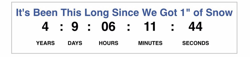
This morning at 7 AM the National Weather Service was forecasting between 1″ – 4″ of SNOW in Nashville.
Current Temps and Radar
At 2:11 PM, NWS-Nashville canceled the Winter Storm Warning in Davidson County and replaced it with an Ice Storm Warning effective until Tuesday at 9 AM. Williamson County is also under the same Ice Storm Warning until 9 AM Tuesday.
Current Temps and Radar
Sleet and freezing rain has arrived. This is not what we ordered. Roads – especially untreated secondary roads – are a slippery mess. Car wrecks everywhere. It’s not safe to drive right now. Will says the treated roads are slushy, bad but passable with his Jeep, in 4WD, equipped with specialized snow tires. Untreated roads are much worse.
You must be logged in to post a comment.