Fireworks? Ruh Roh

Current Radar

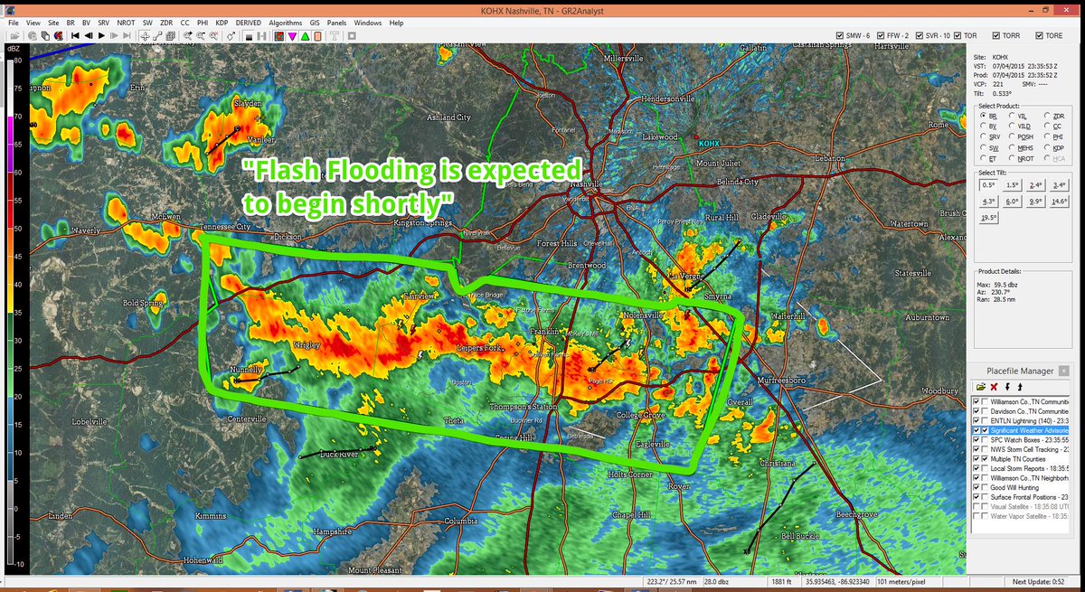
630 PM Update: A Flash Flood Warning is in effect for Williamson County. If you’re in the green box, my advice is to stay home.
This Afternoon and Tonight – Looks Rainy

The stationary front remains north of us. Rain and storms have been firing off it as it feeds off the humid air mass overhead.

Remember the heavy rainer at 2 PM downtown? See the purple-circled area below:

It rained so hard, it transported rain cooled air along the surface, which spread south along the purple arrows. This “outflow boundary” has been the focus of rain and thunderstorms in Williamson Co as I write this at 5:30 PM:

Meanwhile, the black arrows show the approach of rain from the south and southwest, being shoved along by a low-pressure circulation moving east from the Memphis area:

Stop Being a Weather Nerd. What About Fireworks?

The HRRR thinks it will be steadily raining at 9 PM.

Just to look at it, I think it’s overdoing the amount of precip we will see. When I look up at the radar at 5:28 PM, it’s just not so wet that I think it’ll be this wet at 9 PM.

But, even the NAM4 model is in on the rainy idea. It thinks it’ll be very rainy at 9 PM.

Well then.

My gut — which is not scientific — thinks these models are showing it being rainier than it will be, but I don’t think it’ll be dry tonight. The further south you go from Nashville, the wetter I think you’ll be.

My recommendations about fireworks tonight.

1.  Go. It’s reasonable to stay home, but if you like fireworks and crowds, just go. So you get wet. Big deal.

2.  No severe weather is expected.

3.  Have a rain jacket in your car. And wear sensible shoes.

4.  Because America.

USA!

(your computer/phone isn’t broken, the gif is supposed to do that)

Because we’re approaching the target forecast hour (9 PM), this will be the last post of the night. We will post updated radar shots and more info to @NashSevereWx tonight.

If the forecast busts, remember:

Sunday – Chance of Showers and Thunderstorms Remains – High: 84°

The weather pattern shifts back to normal, with a pop-uppy chance of showers and storms into next week.

This website supplements @NashSevereWx on Twitter, which you can find here.

Fireworks Update!

Current Radar

This Afternoon and Tonight – Looks Rainy

A stationary front has set up just north of us. Rain and storms are firing off it as it feeds off the humid airmass overhead:

Expect scattered showers — some heavy at times — to move east this afternoon.

What About Fireworks?

Ummm.

We have the issue with the stationary front described above.

The other — more concerning — issue is the mid-level disturbance to our southwest.

This guy:

This thing is modeled to move along and south of I-40, right into Middle Tennessee tonight.

The HRRR shows it moving like this:

To be more specific, at 9 PM the HRRR thinks it’ll be right here:

If we are taking this model literally, which you should never do, but to be ridiculous let’s do it: this means Nashville and the 300,000 people watching the fireworks show will be dry, everyone south will not.

Do not take it literally.

As I wrote this morning: the weather models don’t have the answers. They tell us there is a decent chance of rain, but we can’t say for sure if it’ll be raining for fireworks tonight.

My recommendations about fireworks tonight.

1.  Go.

2.  So it rains. So what? It’s the Fourth. Fireworks are awesome.

3.  No severe weather is expected.

4.  Have a rain jacket in your car. And wear sensible shoes.

5.  Because America.

USA!

(your computer/phone isn’t broken, the gif is supposed to do that)

We will post updated HRRR model runs and radar updates to @NashSevereWx throughout the day.

If the forecast busts, remember:

Sunday – Lower Chance of Showers and Thunderstorms – High: 82°

The weather pattern shifts back to normal, with a pop-uppy chance of showers and storms into next week.

This website supplements @NashSevereWx on Twitter, which you can find here.

Should You Plan To See Fireworks Tonight? I Think So.

Current Radar

Today – Watching For Rain – High 81°

The main rain band has set up well south of us:

I drew white squiggly lines on the above image to show little ripples/waves in the clouds, extending all the way back to Oklahoma. A few small showers were forming along that route this morning.

The HRRR model thinks rain will form along I-40 all day. It’ll be a cloudy day full of off and on showers; however, it won’t be a total washout. Only 0.18″ of rain is forecast.

A Flash Flood Watch remains in effect until 7 PM tonight.

What about 9 PM?

The last three runs of the NAM4 model have put heavy rain south (in Franklin), north (in Springfield), and north (in Hendersonville) exactly at 9 PM. In each run, that shower had either come from, or was going to, downtown Nashville.

The last two runs of the HRRR keep the 9 PM rain south of both counties. The third does not have it going north of Franklin.

I say that all to say this: the weather models don’t have the answers. They tell us there is a decent chance of rain, but we can’t say for sure if it’ll be raining for fireworks tonight.

My recommendations about fireworks tonight.

1.  Go.

2.  So it rains. So what? It’s the Fourth. Fireworks are awesome.

3.  No severe weather is expected.

4.  Have a rain jacket in your car.

5.  Because America.

We will post updated HRRR model runs and radar updates to @NashSevereWx throughout the day.

Sunday – Lower Chance of Showers and Thunderstorms – High: 82°

The weather pattern shifts back to normal, with a pop-uppy chance of showers and storms into next week.

This website supplements @NashSevereWx on Twitter, which you can find here.

Rain On The Fourth?

Current Radar

Overnight – Maybe A Few Showers After Midnight

Showers and storms over Kentucky tonight have weakened. We will remain comfortably south of all that, with only our new, home grown, light showers to contend with beginning sometime around midnight (maybe a bit before then for Williamson County).

The Fourth – Watching For Rain – High 81°

A Flash Flood Watch remains in effect until 7 PM Saturday.

Our skies remain full of precipitable water, which will translate to rain as shortwaves ripple through Middle Tennessee on Saturday.  The question is: when will they ripple?

Weather models aren’t that much help in telling us when, and where. Generally, most (but not all) of the day looks dry, with only a few passing showers.

Then, rain activity increases as you get closer to:

The NAM4 model puts us in a rain sandwich at fireworks time, almost miraculously keeping us dry.

You don’t want to be between those two rain bands.

The GFS and Euro models keep all that rain about 80 miles south of what’s shown above in the NAM4. Either way, we have a decent shot of rain.

I’ll feel better about the forecast in the morning, when the HRRR will come into range. Maybe those model runs will help us build a consensus. I’ll be up tweeting, and I’ll update this site.

Notice the un-July temps. Only 81°! All in all, a cloudy, occasionally rainy day, with some potential to be wet for fireworks.

No severe weather is expected.

Sunday – A Slightly Lower Chance of Showers and Thunderstorms – High: 85°

The rain-shenanigan-maker shifts a bit east. We’ll still probably see some rain, but not that much.

This website supplements @NashSevereWx on Twitter, which you can find here.

More Rain & Storms, But It’s Not All Bad News

Current Radar

Tonight – Radar trends show storms north, rain south, but we may stay dry (but windy)

Davidson County is included in a Flash Flood Watch until Saturday at 7 PM.

2″ to 4″ additional inches of rain are possible; however, the short-range models have arrived and are suggesting it may not be quite this bad.

Williamson County was the subject of an overnight Special Weather Statement, estimating rainfall in the 1″ to 2″ range today through Saturday.

Caution: the atmosphere is extremely juiced up, so pinpointing the when and where of any rain this weekend is pretty much impossible.

Independence Day – Widespread Showers and Thunderstorms, But Not A Total Washout – Waking Up: 67° High: 81°

If you believe the NAM4 model, the Fourth won’t be all that rainy. It thinks we will see a few showers and storms pop up during the afternoon and evening.

Good news for:

Music-City-Hot-Chicken-Festival-512x424

What about fireworks, you say?

Independence Day Evening – Take the rain jacket, wherever you’re going to watch the sky explosions.

If you are heading downtown to watch the fireworks:

7:00pm: 78° 

The NAM Model has brief showers and storms in the area in the evening. The only threat would be damaging winds and heavy rainfall.

SAT 7PM

9:00pm: 74°

Showers and thunderstorms continue to move south.

SAT RAIN

Don’t pay too much attention to the location of the showers in this model.  The point is knowing that rain and a few thunderstorms may be in the area. They may leave us alone downtown.

Sunday – Widespread Showers and Thunderstorms – Waking Up: 66° High: 83°

Showers will be mainly east of I-65 in the morning and into lunchtime. Showers will pop up in the afternoon and move east across Middle Tennessee.

The Quantitative Precipitation Forecast (QPF) shows that we will get about 1″ of rain from Friday through Monday morning. Some neighborhoods will see higher than 1″ of rain.

d13_fill

Extended: Rain chances and a warming trend into Tuesday…

Screen Shot 2015-07-03 at 8.01.30 AM


Editor’s Note: here’s video of the tornado in Wilson County yesterday:

Oh, one other thing. it wasn’t the tornado that killed someone last night. Please be careful out there, y’all:

This website supplements @NashSevereWx on Twitter, which you can find here.

Slight Risk for Severe Storms Continues This Evening

Current Radar

THIS EVENING – SHOWERS & STORMS CONTINUE 

We are under a slight risk for severe thunderstorms through early tomorrow morning:

While strong storms are likely to continue for areas inside this brown line, we’re not expecting a severe thunderstorm watch to be issued:

Damaging winds and hail will be of greatest concern with today’s storms:

The tornado risk is practically non-existent:

Here’s NWS Nashville’s threat graphic, which includes flooding:

The flooding risk has been raised a bit today, and will continue to be of concern as more rain arrives through the weekend.

HRRR future radar loop from lunchime to 2 AM shows most — but not all — of the evening rain and storm activity to our south:

However, it doesn’t look like activity will end completely overnight. Lows will remain near 70°.

In addition, tonight our NWS office issued a Flash Flood Watch for Davidson County, where an additional 2″ to 4″ of rain is possible through Saturday night.

FRIDAY – Another Day, Another Chance for Rain – Wake Up: 70°, High: 80º

We have a marginal risk for severe thunderstorms tomorrow:

Tomorrow looks similar to today, with showers and storms beginning early and continuing throughout the day. However, we may catch a bit of a break early-on:

But, things will pick up by the afternoon:

If you’re headed to the USMNT game tomorrow evening, things don’t look too bad, according to this model:


We’ll know more as more model runs come out today, but hopefully we’ll catch a break tomorrow evening for the game.

SATURDAY – A Rainy 4th – Wake Up: 67°, High: 80º

Rain chances will continue into Saturday, as the dip in the jet stream over the eastern US will continue to allow disturbances (rainmakers) to move through the Midwest and swing rain/storms our way.

Unfortunately, it looks like we won’t be able to shake this pattern until after this weekend. If you have outdoor plans for the 4th of July, I would start making indoor plans.

Looks like a wet afternoon:

And, a wet evening:

EXTENDED: Wet Weekend Ahead

With so much rain in the short-term and extended forecasts, NWS Nashville issued this statement on flooding concerns:

Remember: Turn Around, Don’t Drown. Take it easy out there!

This website supplements @NashSevereWx on Twitter, which you can find here.

After The Storms…

Current Radar

*Updated with Severe Thunderstorm Watch at 11:50 AM – Kaiti* 

TODAY – Storms Gone…For Today – High: 83º

Both the HRRR model (shown) and the NAM4 model (not shown) agree that this afternoon’s activity will be southeast of us well before 7 PM:

However, as the pink arrow above indicates, more rain may arrive late tonight:

Showers and some storms are possible through the overnight hours. But I think your awake-time tonight should be OK for going out, Sounds game, etc.

Temperatures overnight will fall to around 70°.

THURSDAY – Slight Risk for Severe Storms Once Again – Wake Up: 70°, High: 81º

As of this morning, we are under a slight risk tomorrow, as well:

We’ll likely get off to a rainy start, followed by more afternoon showers and storms:

So, what is causing all of this rain? I like to think of it as the Disturbance Carousel:

The dip in the jet stream over the eastern US is allowing for disturbances (rainmakers) to continue to move through the Midwest and swing rain/storms our way.

Unfortunately, it looks like we won’t be able to shake this pattern before the 4th of July this weekend.

Start making indoor plans, just in case.

EXTENDED:  Dodging Storms on the 4th 

This website supplements @NashSevereWx on Twitter, which you can find here.

Update: Marginal Risk for Severe Storms Today

Current Radar

*Updated with latest SPC update at 12:27 PM -Kaiti

THIS EVENING – Staying Dry (Most Likely)

We have been downgraded to a MARGINAL risk of severe thunderstorms today:


Here’s the breakdown of wind, tornado, and hail risks:

Flooding is also of concern today, as these storms will likely produce heavy downpours.

NWS Nashville puts the flooding threat between LOW and MEDIUM:

As evening approaches, both models also agree that things will begin to quiet-down by 7 PM or so:

Now, what’s to blame for all this? That would be a weak cold front that’s still off to our north this morning. As it swings through today, our storm chances go up.

For more immediate updates, stick with us on Twitter throughout the day.

Mild overnight temps near 70°.

WEDNESDAY – More Afternoon Storms – Wake Up: 69º, High: 83º

Tomorrow brings another chance for rain, and the severe risk will also be marginal:


Another front will hang around to our north, allowing for storms ahead of it to head our way.

Timing: a few showers may roll through overnight, but most storms will roll through tomorrow afternoon and evening.


EXTENDED: Thunderstorm Chances Each Day through the 4th 

This website supplements @NashSevereWx on Twitter, which you can find here.

I-24 Storms Tonight, More Rain/Storms This Week

Current Radar

Tonight – Thunderstorms

The I-24 Storms are coming from the NW. See the above radar and follow us on Twitter @NashSevereWx for more info. These have strong, and maybe severe, potential.

The Storm Prediction Center still has our probability of a hail or a damaging wind event within 25 miles of us at 5%. We are excluded from their tornado outlook.

Tuesday – More Waves, More Rain Chances – High 87°

This week we expect a series of shortwaves, or impulses, or whatever you want to call them, ripple through the atmosphere, setting off rain and storm chances.  You want to know when, where, and how much, right?

Pinpointing when/were/size is almost impossible: the variance in each model is wide. NWS-Nashville wrote this morning that “the timing and strength of these upper-level impulses will deviate from day to day.” It’s nothing like the predictable, repetitive wave image above.

With temps and dew points climbing, rain is a good bet at some point Tuesday, probably in the afternoon or early evening. I could post model data here, but the variance is so wide that it’s not worth your time.

Wednesday – Better Rain Chance – High 82°

The best chance for rain this week is Wednesday night into Thursday. However, models are showing rain mid-day as well. Temps forecast in the low 80°s reflects belief in cloud cover and rain.

Be prepared for rain and maybe a thunderstorm or two Wednesday.

Mid-Week: Wet & Stormy Pattern Continues

This website supplements @NashSevereWx on Twitter, which you can find here.

I Think You Can Handle The Truth

Current Radar

Today – Humidity, Rain & Storm Chances Return – High 87°

Showers and maybe a few storms may swing through this afternoon. The HRRR model sure thinks so:

I chose this wide view because it shows this week’s “source” of rain/storm activity: the northwest.

A few of today’s storms could be strong, or even marginally severe.

The Storm Prediction Center puts the probability of a hail or damaging wind event within 25 miles of us at 5%. We are excluded from their tornado outlook.

Tonight, another wave of upper level energy will arrive, delivering more rain and storm chances.

Tuesday – More Waves, More Rain Chances – High 88°

This week we expect a series of shortwaves, or impulses, or whatever you want to call them, ripple through the atmosphere, setting off rain and storm chances.  You want to know when, where, and how much, right?

Pinpointing when/were/size is almost impossible: the variance in each model is wide. NWS-Nashville wrote this morning that “the timing and strength of these upper-level impulses will deviate from day to day.” It’s nothing like the predictable, repetitive wave image above.

With temps and dew points climbing, rain is a good bet at some point Tuesday, probably in the afternoon or early evening. I could post model data here, but the variance is so wide that it’s not worth your time.

Wednesday – Better Rain Chance – High 86°

The best chance for rain this week is Wednesday night into Thursday. However, models are showing rain mid-day as well.

Just be prepared for rain and maybe a thunderstorm or two Wednesday.

Mid-Week: Wet & Stormy Pattern Continues

This website supplements @NashSevereWx on Twitter, which you can find here.