Winter Storm Warning Starts at 6pm Today. Preparing for Dangerous Cold and Travel Impacts.

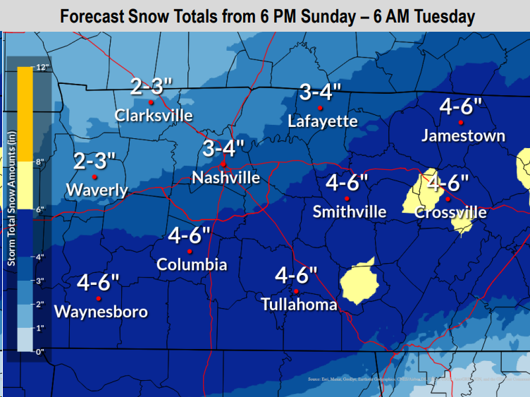
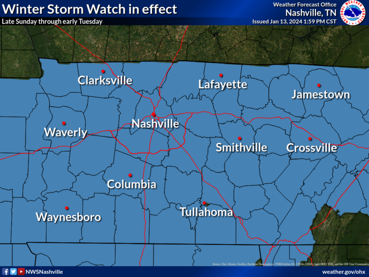
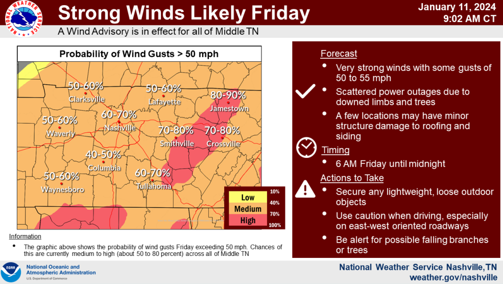
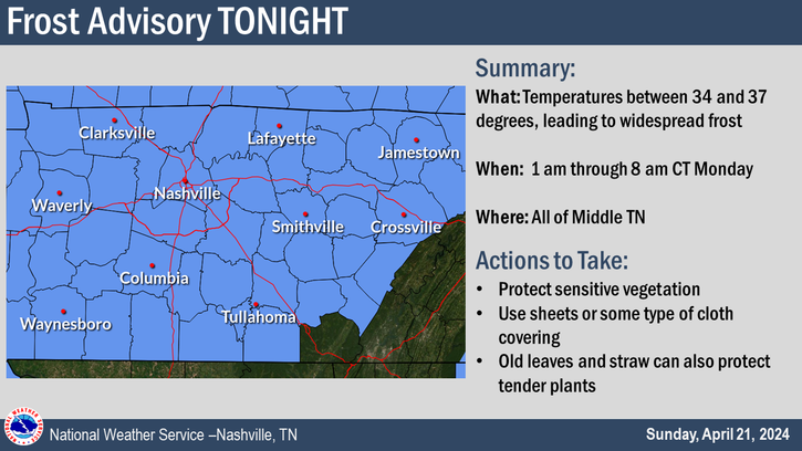
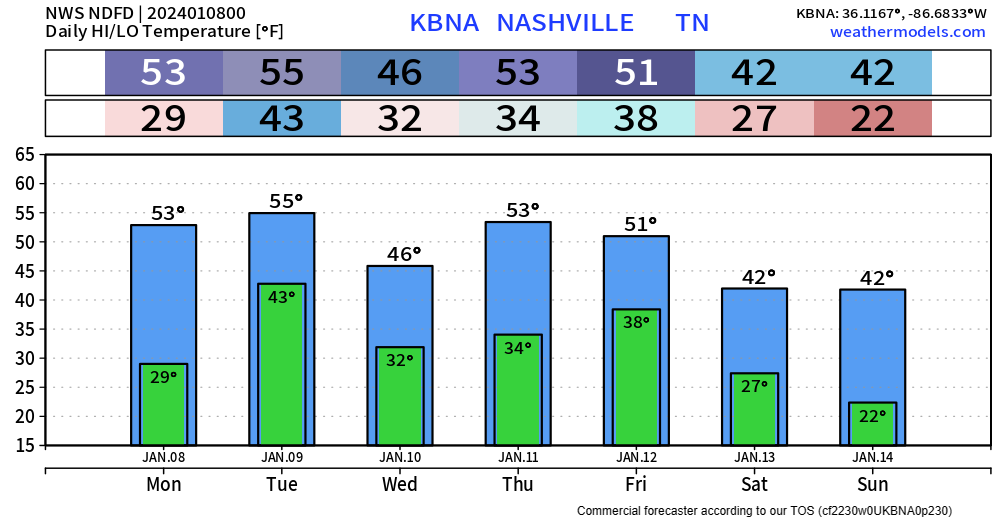
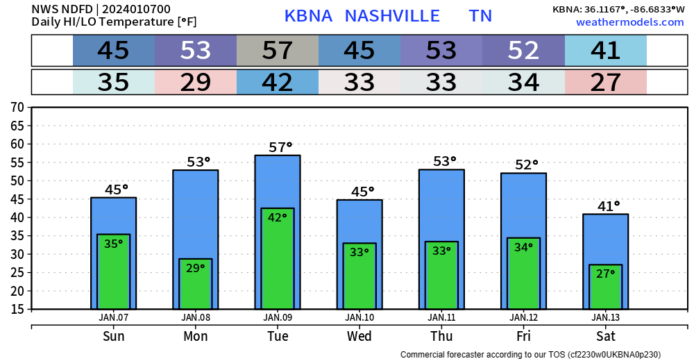
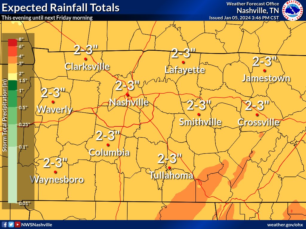
Our Winter Storm Watch has been upped to a Winter Storm Warning, valid from 6pm tonight thru 6am Tuesday. Although our impacts will last beyond Tuesday AM.

Our most likely snowfall totals remain around 3 – 4″. This is still subject to change, higher or lower. read more

Winter Storm Watch Sunday Evening - Tuesday AM, Prepping for Dangerous Cold + Travel Impacts

Overnight tonight a cold front will swing thru, bringing in our very cold air. Along the front, there could be some flurries. Areas north of I-40 could see a dusting, no major impacts expected.

Both of our counties are under a Winter Storm Watch from Sunday evening thru Tuesday morning. This will likely be changed to a Winter Storm Warning later tonight or tomorrow. read more

Wind Advisory Remains Thru Midnight, Dangerous Cold Arrives Sunday, Discussing Snow Probabilities

A majority of the rain has moved out. Can’t rule out a few scattered showers this afternoon/evening, but our severe threat is over.

We still have a Wind Advisory thru midnight tonight, wind gusts up to 45 – 55 mph will be possible. read more

High-End Wind Advisory & Strong Storms Possible Friday. Frigid Air Likely, Maybe Snow Early Next Week.

Enjoy the rest of this nice day today, our weather will change rather quickly tomorrow.

Yet another Wind Advisory has been issued for us from 6 am Friday thru midnight Friday.

Sustained winds from the SW at 25 – 35 mph with gusts up to 55 mph are expected. The graph above from NWS Nashville shows our odds of wind gusts 50+ mph at 60-70%. read more

More Wind & Storms(?) Friday. Dangerous Cold Arrives Early Next Week. First Legit Snow Chance of the Szn?

A busy forecast coming up for us.

The rest of today and Thursday will be calm. Thursday + Friday we’ll even be 5-10 degrees above average. Enjoy this, it will not last long.

Friday things change. read more

Windy & Rain/Snow Mix Tonight, Deja Vu Friday, And Talking About COLD + Sn*w Potential

Lots to talk about before we dive into the wintry weather potential.

We still have a Wind Advisory to deal with until 6am Wednesday morning.

Wind gusts up to 40 – 45 mph are possible overnight. Could wake you up, but no need for concern. read more

Wind Advisory & Heavy Rain Tonight - Tuesday. More Rain Friday. Mumbles of Winter Wx Next Week.

The graphic above from NWS Nashville sums up our Wind Advisory that goes thru 6pm tonight thru midnight Tuesday night. Not a bad idea to charge your phones in case a tree branch decides to land on a powerline, secure all outdoor furniture. read more

Heavy Rain & Wind Advisory Monday PM + Tuesday, Another System Thursday/Friday, Arctic Air Incoming?

There’s a lot to break down. Let’s do it.

Wind Advisory

When? 6pm Monday – 6pm Tuesday

What? Sustained winds from 15-25 mph, with gusts up to 35 – 45 mph will be possible

Winds could blow around unsecured objects; tree limbs could also get blown down and cause a few power outages. read more

Quick Showers Tonight, Heavy Rain & Gusty Winds Monday PM - Tuesday

Some light showers moving thru this evening, these should not last long, and should be outta here in the next couple of hours.

We’ll be dry for Sunday, but high temps will only make it up into the mid 40s, bundle up if venturing out to the Titans game. read more

Cold Rain Tonight, Rain & Gusty Winds Monday/Tuesday

Rain will be a common theme in our forecast for the next 7 days.

HRRR above gives a good look at what the radar might look like tonight into early Saturday morning:

  • a cold rain (just rain)
  • arriving ~ 9 – 10 pm
  • departing ~ 6 – 7 am Saturday
  • 0.5″ – 1″ of rain expected

Rest of the day Saturday should mostly be dry. A few isolated, quick rain showers are possible Saturday evening. read more