
Our Winter Storm Watch has been upped to a Winter Storm Warning, valid from 6pm tonight thru 6am Tuesday. Although our impacts will last beyond Tuesday AM.
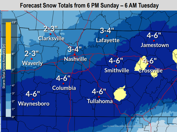
Our most likely snowfall totals remain around 3 – 4″. This is still subject to change, higher or lower.
The narrow band(s) of heavier snowfall is expected to be south of us, in the 4 – 6″ area. However, this band(s) could shift north or south, raising or lowering our totals.
Looking for our “boom” and “bust” scenarios, the Euro illustrates our “bust” potential at 0.5″ – 1.5″. The SREF Ensemble continues to represent our “boom” scenario with 6 – 7″. Although these scenarios are not likely, they are also not impossible. Currently, our most likely outcome is 3 – 4″.
Timing
ETA of our first flakes appears to be around ~5/6pm. Snow is expected to continue throughout the majority of the night, tapering off a bit Monday morning. We may get a break Monday morning thru about midday, with more snow Monday afternoon/evening. Snow should end after sunset Monday.

Above is the latest (12z) HRRR model. This is just one run of one model, and it could be off, other models think differently. This is just meant to give you a general idea of what the radar *could* look like. Timing is subject to change.
Impacts
With temperatures expected to be well below freezing throughout the duration of the event, once the snow starts falling, it will not have much problem accumulating, including on roads. Even if we do end up on the lower end of our forecasted snow totals, travel will still be negatively impacted.
Road conditions will start to deteriorate this evening as the snow starts, worsening overnight and into Monday.
There is no way of knowing how ‘x’ road will be at ‘y’ time. If you don’t have to get out, the best bet would be to stay off the roads. However, if you have to travel, you know your vehicles’ limit best, please don’t push them. Generally speaking, “major” roads such as interstates will be in better conditions than backroads, but better doesn’t mean clear.

If you do drive, please clear any snow off your vehicle and take it slow.
BNA is equipped to deal with snow, but we have no way of knowing if your flight will be delayed/canceled. We also don’t comment on school closures, sorry kiddos/hopeful teachers.
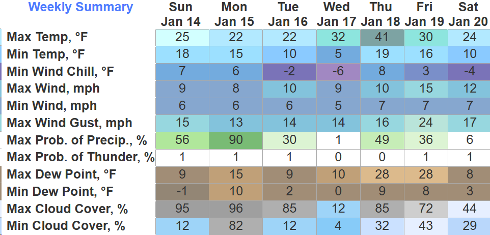
Along with the impacts from snow, we will also be dealing with dangerous cold temperatures. We fell below 32° last night and we won’t get back above freezing until sometime Thursday, ~100 consecutive hours of below freezing. We likely will not see much melting until Thursday.
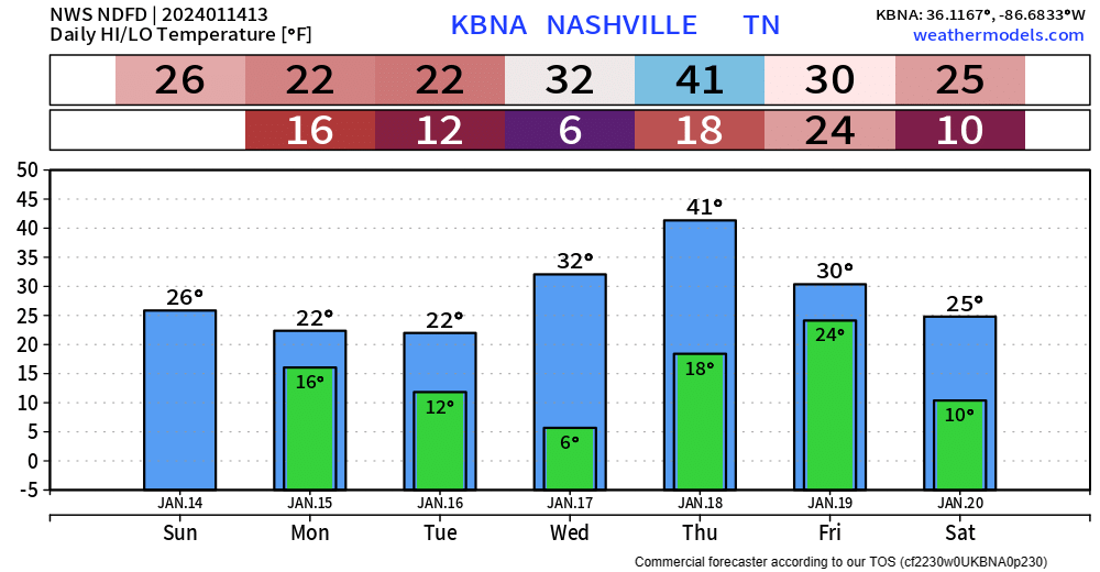
Tuesday and Wednesday mornings will be our coldest, with wind chill values around -5 to -10°. A Wind Chill Advisory may be needed. Wind chill values are expected to stay in the teens/single digits during the day Monday and Tuesday.
If going outside, make sure to dress in multiple warm layers. Frostbite and hypothermia can set in quickly.
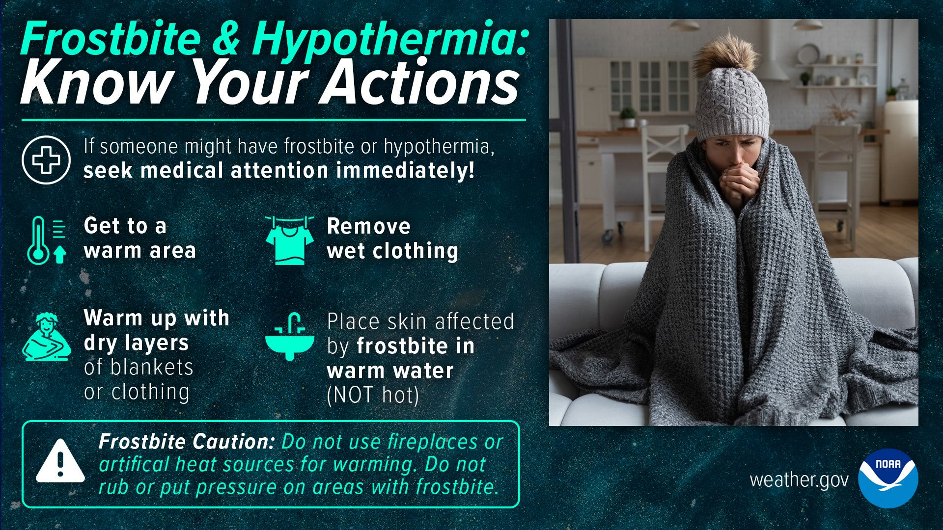
Remember the 4 P’s – people, pets, pipes and plants.
Below are some things to consider doing in preparation for the cold:
*Changes to the forecast are possible, it’s important to stay connected throughout the day.* We’ll be tweeting as needed and have another blog out this evening.
Another system is possible Thursday night/Friday AM, bringing another chance of wintry precip. Accumulation/impacts are unknown at this time. We probably won’t get above freezing Friday or Saturday.
Quick References:
Weather changes constantly.
Follow @NashSevereWx on Twitter for any changes to this forecast.
Live coverage during tornado and severe thunderstorm warnings:

Look good.
Support the mission.

We are 100% community supported. No ads. No subscription fees. Keep it free for everyone.


Categories: Forecast Blogs (Legacy)
You must be logged in to post a comment.