
Enjoy the rest of this nice day today, our weather will change rather quickly tomorrow.
Yet another Wind Advisory has been issued for us from 6 am Friday thru midnight Friday.
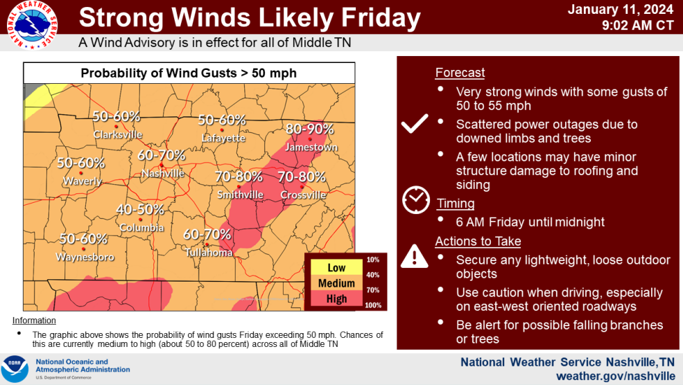
Sustained winds from the SW at 25 – 35 mph with gusts up to 55 mph are expected. The graph above from NWS Nashville shows our odds of wind gusts 50+ mph at 60-70%.
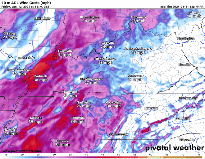
The HRRR model (above) shows non-thunderstorm wind gusts really picking up after sunrise, lasting throughout the majority of the day.
Wind gusts this strong for a prolonged amount of time can knock down trees, power lines, and even cause structural damage. If possible, try not to park near any trees tomorrow. Keep devices charged in case of power loss. Driving may also be difficult tomorrow (esp. high-profile vehicles), particularly on east-west roads, such as I-40. Secure any outdoor furniture, trampolines, etc.
Along with the threat for strong non-thunderstorm wind gusts, we also have a low, but non-zero chance for severe weather tomorrow.
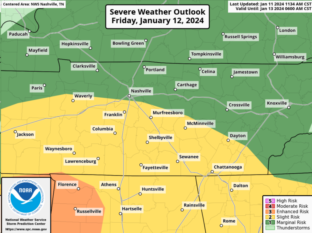
Areas in yellow (basically areas south of I-40) have been outlooked with a:
- 15% chance of damaging straight-line winds within 25 miles
- 2% chance of a tornado within 25 miles
The rest of the area outlooked in green (mainly areas north of I-40) are outlooked with a:
- 5% chance of damaging straight-line winds within 25 miles
Try not to pay too much attention to where the lines are drawn, everyone has a low, but not-zero chance of severe weather. *Everyone* has the chance of non-thunderstorm wind gusts up to 55mph, which can be just as bad as straight-line winds in a thunderstorm.
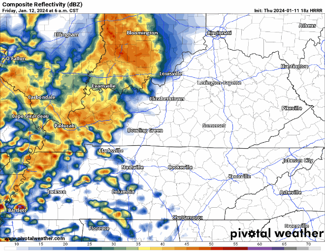
The HRRR (above) shows widespread rain/storms starting out around sunrise Friday, lasting thru about noon. ETA subject to change.
Winds will likely be howling a majority of the day, however embedded in some of the stronger downpours, 58+mph wind gusts are possible. Our main threat tomorrow is damaging straight-line winds. While a tornado cannot be totally ruled out, the instability/CAPE/storm food needed for tornadoes will be hard to come by.
Details could change as new info comes in, stay tuned for any forecast tweaks.
Even after the rain/storms exit, our Wind Advisory will still be in place, and gusts up to 55 mph will still be possible thru the rest of Friday.
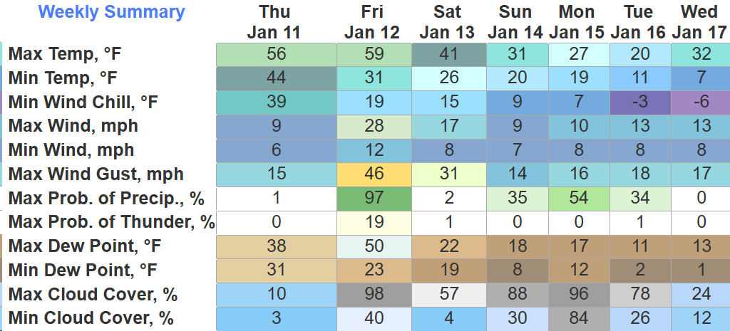
Saturday will be dry, but a lot cooler. High temps will struggle to reach 40°.
Sub-Freezing Temps Expected Sunday – Wednesday
It is looking more and more likely that temperatures will go below freezing Saturday night and not get above freezing until Wednesday/Thursday.
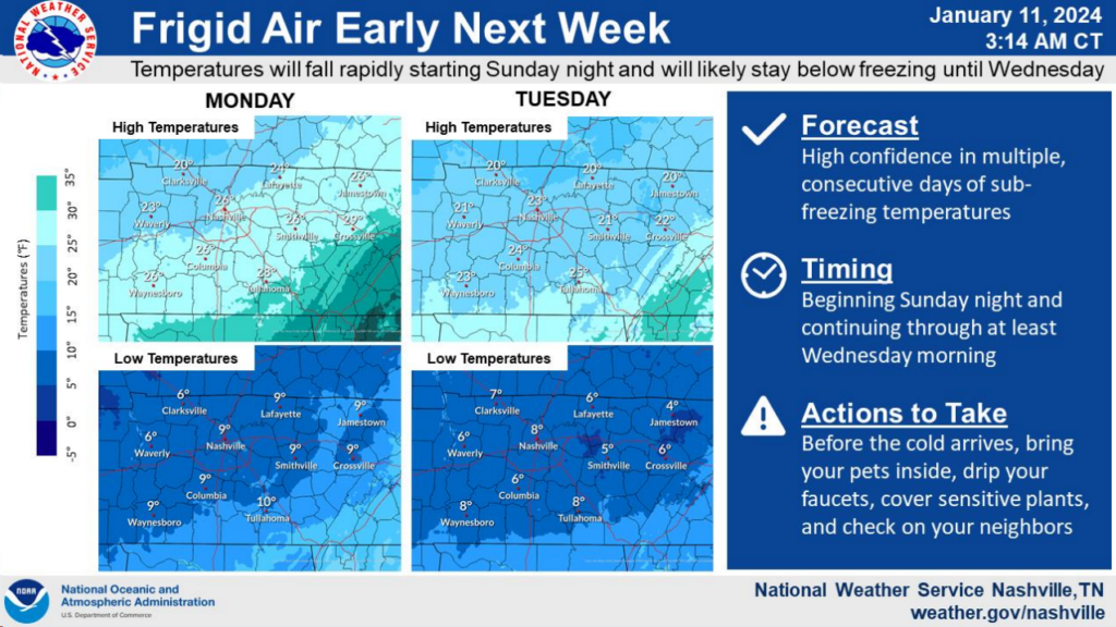
- Low temps in the teens and single digits are possible Monday – Wednesday
- Wind chill values below zero are also possible Monday night and Tuesday night
- High temperatures only reaching the low to mid 20s on Monday and Tuesday
Wouldn’t be the worst idea to go ahead and start thinking about a plan to cover exposed pipes, dripping faucets, making room for pets indoors, and checking in on friends/neighbors who may not have adequate heat, especially if they lose power tomorrow.
And yes, there is still a possibility for snow at some point early next week. Models are still all over the place, and they are hard to trust this far out.
The cold air will certainly be in place, however our source for any moisture is sus, could miss us or just be too dry. Would really like to wait until Saturday to start talking about any snow specifics. Gotta get through Friday’s event first. One event at a time, y’all.
Also, new drought monitor came out today. No big changes from last week…
Quick References:
Weather changes constantly.
Follow @NashSevereWx on Twitter for any changes to this forecast.
Live coverage during tornado and severe thunderstorm warnings:

Look good.
Support the mission.

We are 100% community supported. No ads. No subscription fees. Keep it free for everyone.


Categories: Forecast Blogs (Legacy)
You must be logged in to post a comment.