Rain Ending - Colder with More Rain Chances Later This Week

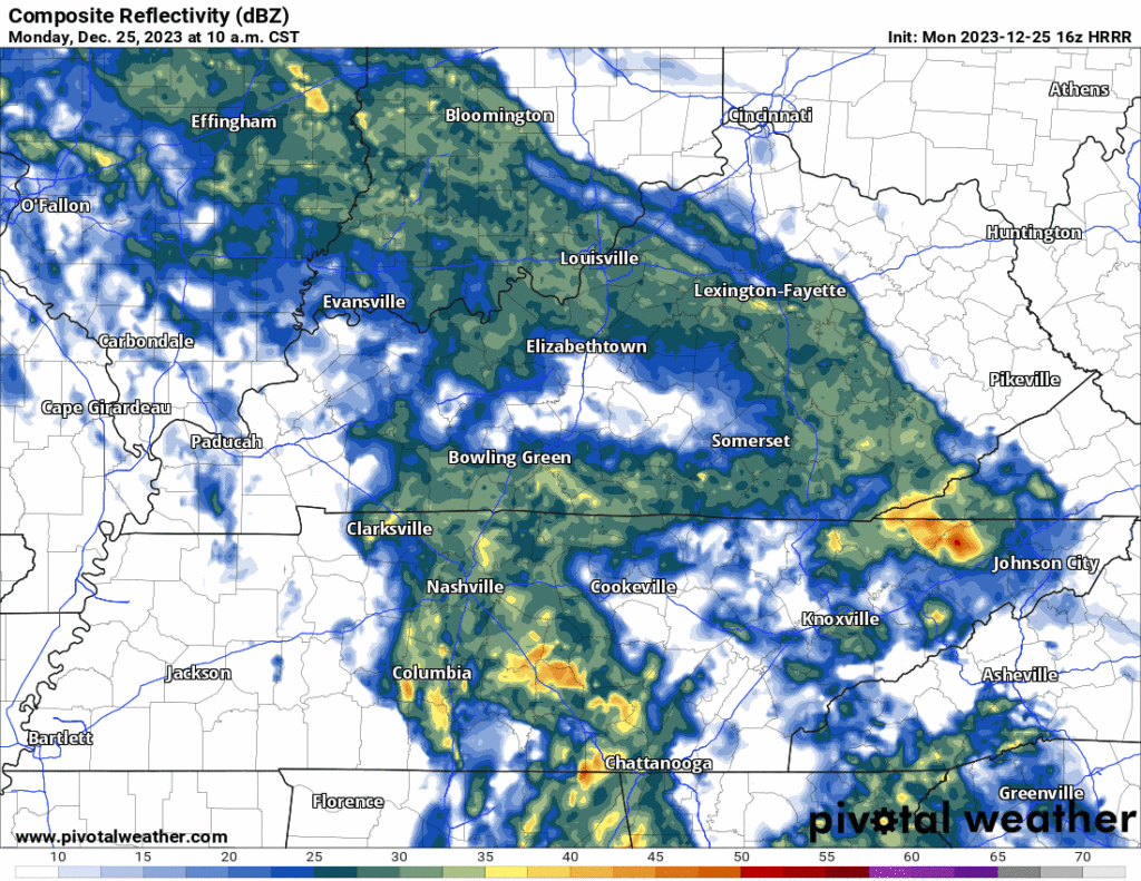
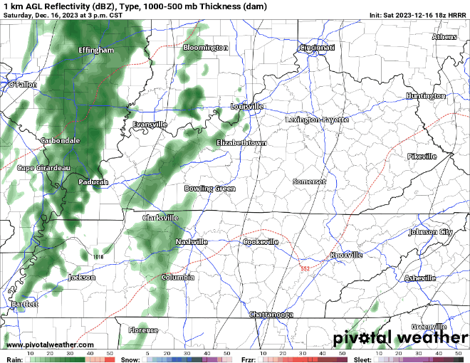
Morning rain will end during lunch. A few hit/miss showers may drive by your place this afternoon, otherwise cloudy with a few breaks of sunshine for some. HRRR model through 7 PM today below:

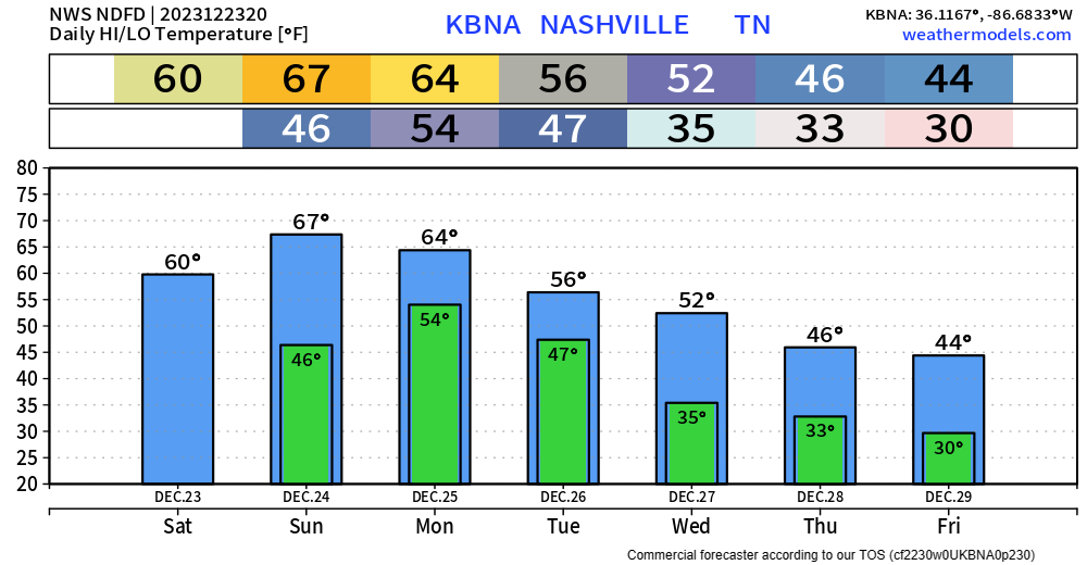
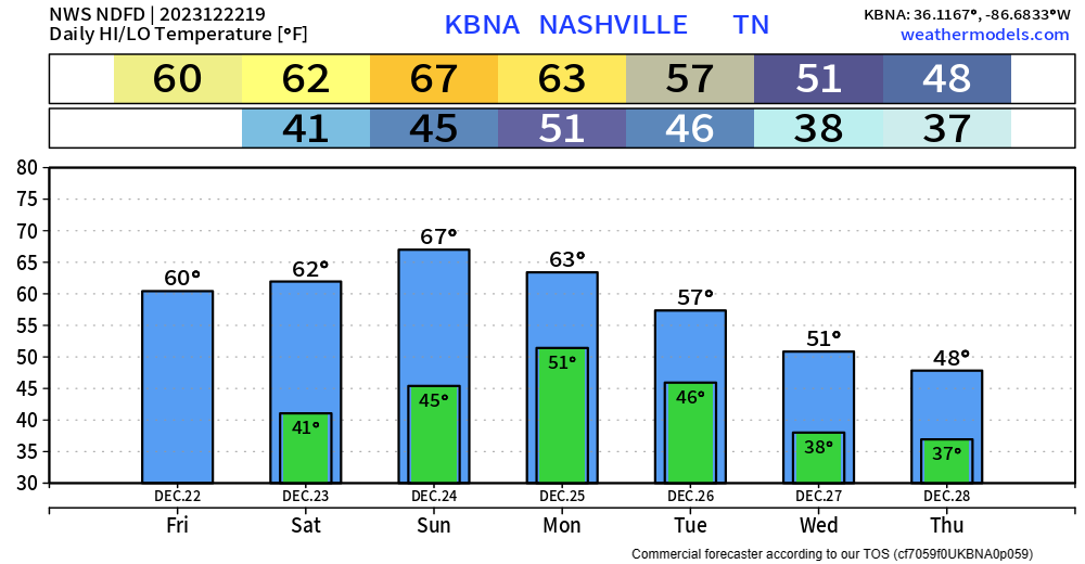
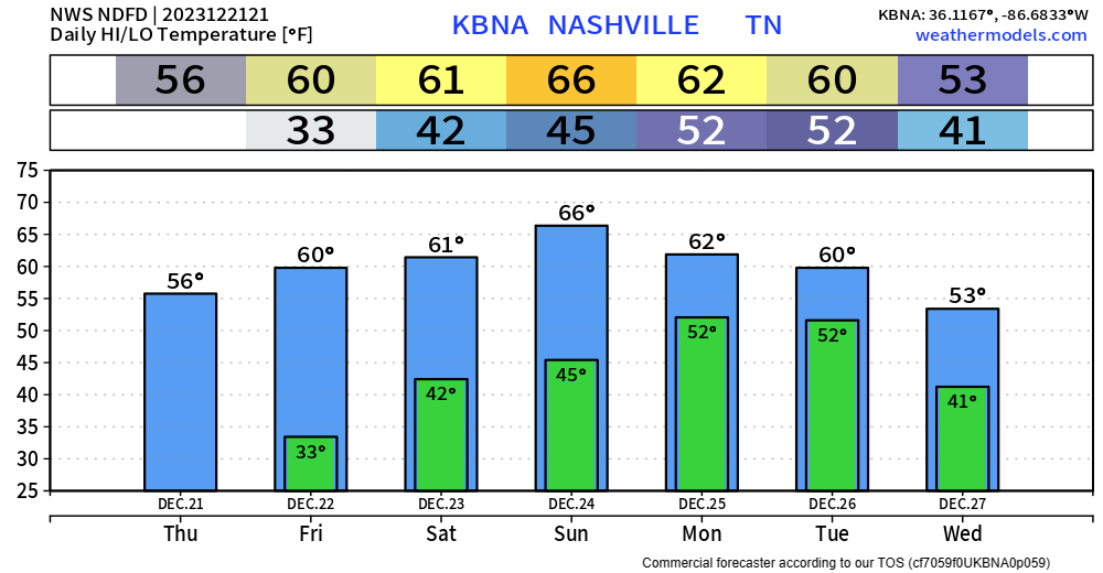
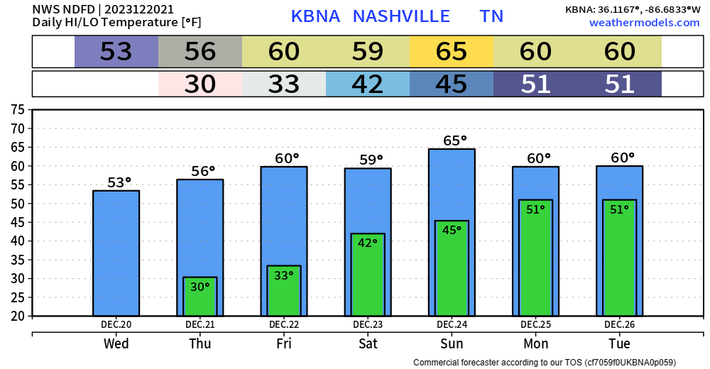
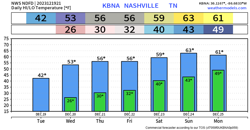
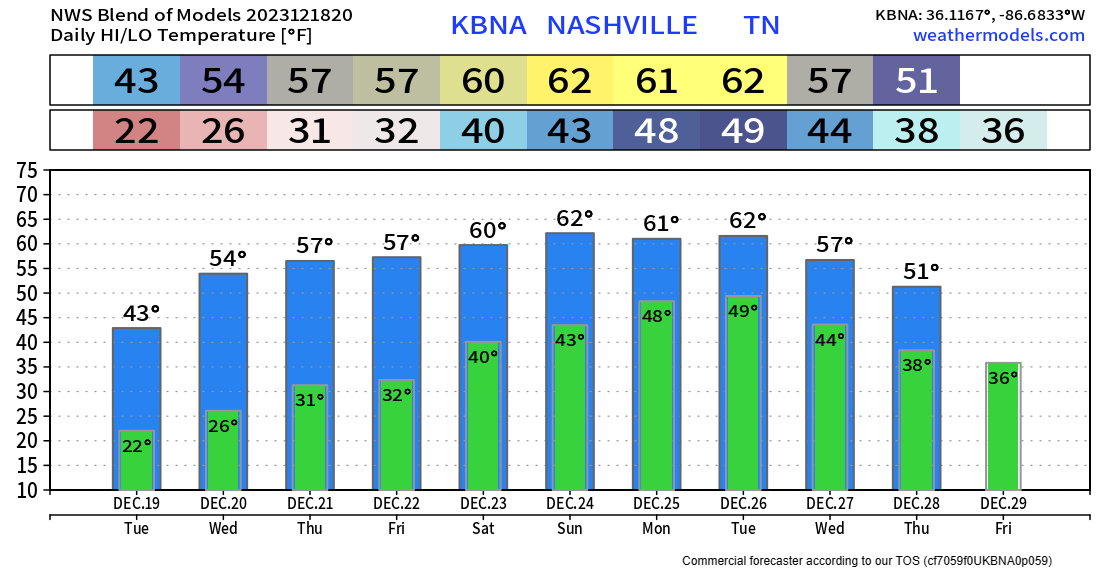
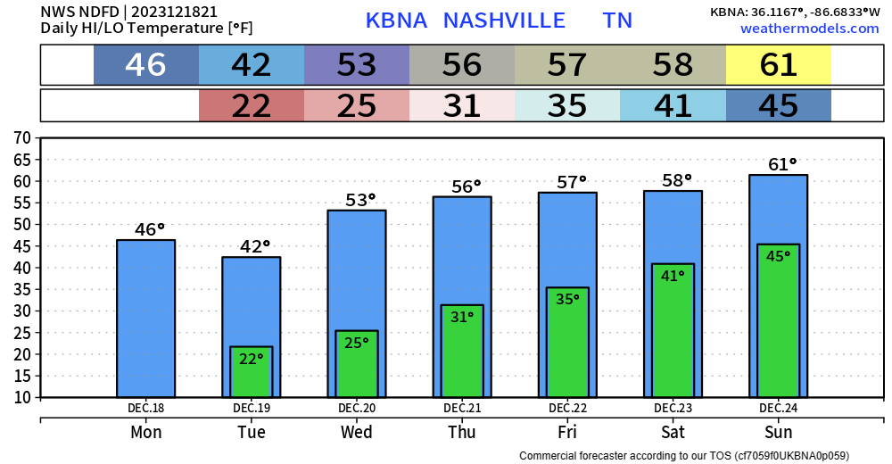
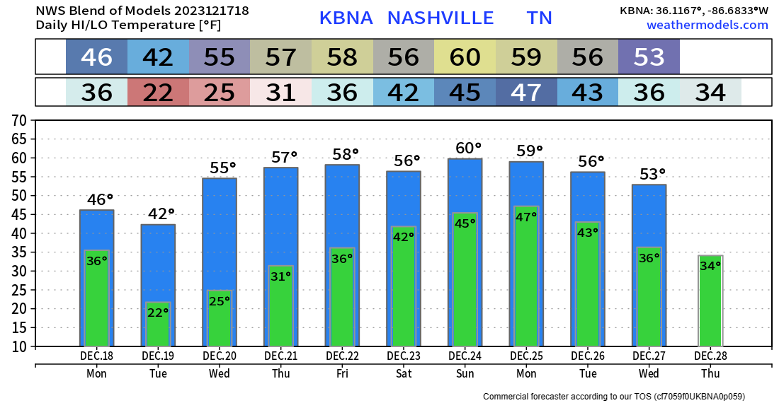
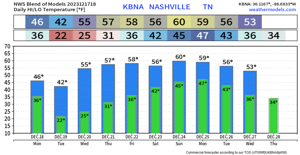
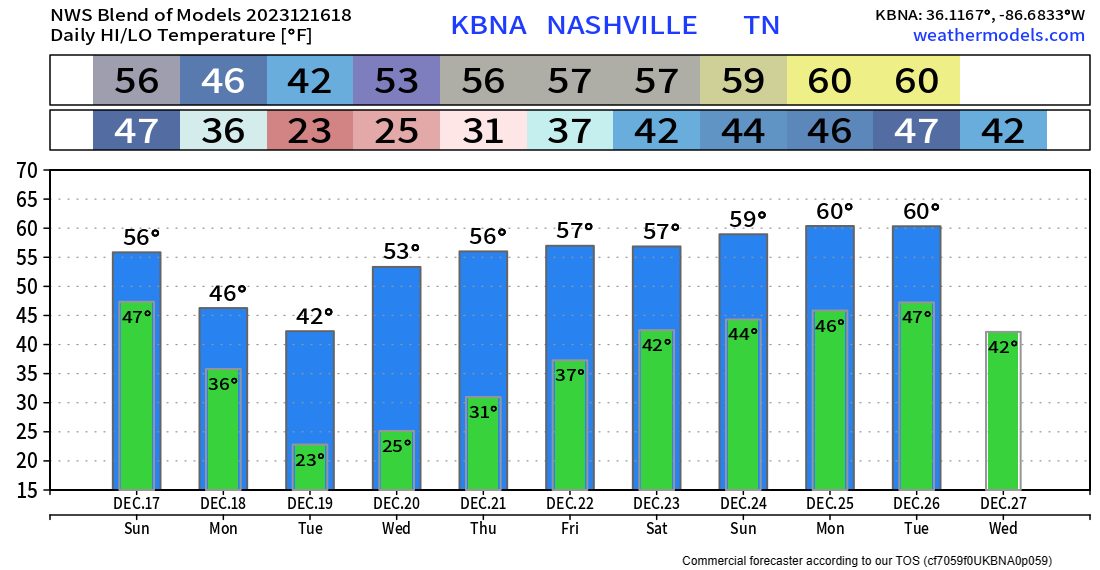
Colder air later this week, wind chills near freezing Weds morning with colder mornings after that.

Next rain event is questionable. Most models think the most likely time is Thursday night. No one is sure about that. Looks right now like a light, cold rain with wintry precip missing us to the north and east.

Another rain event is modeled for New Year’s Day. Best data right now thinks it’s a cold rain without wintry precip. Model data 1 week away is unreliable making it too soon to discuss wintry precip beyond what we’ve already said about it.

Thanks to all you doctors, nurses, police, firefolks, meteorologists and other Essential People working today. You are the real ones.

Quick References:

Weather changes constantly.
Follow @NashSevereWx on Twitter for any changes to this forecast.

Live coverage during tornado and severe thunderstorm warnings:

Look good.
Support the mission.

Shop Merch | Nashville Severe Weather

We are 100% community supported. No ads. No subscription fees. Keep it free for everyone.

Not The Best Forecast For Reindeer, Wet + Windy First Half of Christmas

Gorgeous weather for Christmas Eve, temperatures have crept up into the mid to upper 60s.

Clouds will increase as we go throughout the day, hinting at the incoming rain.

Michael Caine Christmas GIF by Sky

Rough Ride For Rudolph

Not only will rain pick up overnight, but so will the wind.

Winds will pick up after midnight and stick around thru around noon Monday. Not sure we get the 40-45 mph gusts, but gusts up to 30 – 35 mph are possible. Santa may encounter some turbulence. Securing X-mas decorations, outdoor furniture won’t be a bad idea.

Along with the wind picking up around midnight, rain will accompany it.

The HRRR (above) shows a steady rain, heavy at times, sticking around thru noon, becoming scattered thru the end of the day. Rainfall totals expected to be around 0.75″ – 1″.


Tuesday looks dry, along with the majority of the day Wednesday, until some more moisture creeps back in.

Details are still hazy, but occasional showers are possible Wednesday PM thru Thursday. Too far out to try to give any specific timing deets. Your crapapp may show a snowflake towards the end of the week, although air aloft may support frozen precipitation, temperatures at the surface will be above freezing. More details on this as we get closer.

Quick References:

Weather changes constantly.
Follow @NashSevereWx on Twitter for any changes to this forecast.

Live coverage during tornado and severe thunderstorm warnings:

Look good.
Support the mission.

Shop Merch | Nashville Severe Weather

We are 100% community supported. No ads. No subscription fees. Keep it free for everyone.

And Why Is The Carpet All Wet, Todd?

christmas vacation GIF

Because it’s been raining, Margo.

On/off rain has been moving thru throughout the day, and chances will continue thru this evening. You can check the radar anytime here: Radar – Nashville Severe Weather

December 23 Christmas GIF by HULU

Christmas Eve:

A dry and particularly warm Christmas Eve. High temperature of around 67°, which is about 15° above average. Fantastic weather for whatever plans you may have. Carpets will be dry.

Christmas Day:

Your carpet may be wet again on Christmas.

The HRRR (above) shows consistent rain moving in the wee hours of Christmas morning. The best chance of rain appears to be from pre-sunrise to around noon. Scattered showers will still be possible in the PM hours, but we should get some breaks.

Rainfall totals of 0.5″ – 1″ will be beneficial, although not the best timing. No severe weather in the forecast.


Dry Tuesday, some more moisture comes around Wednesday/Thursday which could bring us some showers, but that’s TBD.

As we near the end of the year, temperatures will cool down to where we normally are this time of year.

Quick References:

Weather changes constantly.
Follow @NashSevereWx on Twitter for any changes to this forecast.

Live coverage during tornado and severe thunderstorm warnings:

Look good.
Support the mission.

Shop Merch | Nashville Severe Weather

We are 100% community supported. No ads. No subscription fees. Keep it free for everyone.

What A Difference A Year Makes, Rainy Christmas Expected

A year ago today, I wrote the blog about temperatures expected to get around 0°, wind chills -20° to -30°, with a Winter Storm Warning along with it. NWS Nashville put together a page about this event, you can click here if you’d like to read.

This time around, temperatures aren’t expected to dip below freezing the next 6 days.

As we are only 3 days away from Christmas (sidenote: where in the world did 2023 go), temperatures are in the low 60s, with plenty of sun, making it feel more like early fall.

Saturday:

High temperatures will yet again get up into the low 60s. While doing your last second Christmas shopping for the in-laws that are now apparently staying at your place, you may run into a few showers.

HRRR (above) shows on and off showers possible all day. These will be light and quick moving. An umbrella or rain jacket should suffice.

Christmas Eve:

High temperatures will soar into the mid 60s, not a record, but not very Christmas Eve like. There is an outside shot at a shower or two, but models think we’ll be dry for the day.

Christmas Day:

Wet.

The GFS and the EURO model (Euro shown above) are both in good agreement that a soaking rain will accompany us throughout the morning hours. Rain should become more scattered after lunch, continuing throughout the evening. No severe weather in the forecast. Total rainfall in the 0.5″ – 1″ range, which is much needed.

Rain will exit the area on Tuesday, with low rain chances coming back later in the week.

Still too far out for a legit forecast of New Years, but long-range models are hinting at cooler and drier weather.

If you are looking to impress your family this holiday season, you can drop this crazy stat on them.


Quick References:

Weather changes constantly.
Follow @NashSevereWx on Twitter for any changes to this forecast.

Live coverage during tornado and severe thunderstorm warnings:

Look good.
Support the mission.

Shop Merch | Nashville Severe Weather

We are 100% community supported. No ads. No subscription fees. Keep it free for everyone.

Getting Thru the Shortest Day (Light) of the Year to Get to the Longer Ones

The sun set at 4:36pm today, that’s quite sad. Thankfully, the sun will set later in the day from now on.

Winter will officially begin at 9:27pm, when the Winter Solstice occurs. However, based on the forecast, it sure doesn’t feel that way.

Tomorrow, we embark on a temperature roller coaster.

Video gif. Two elderly women are pretending to ride a rollercoaster. They're sitting in front of a green screen of an extreme rollercoaster and are having fun with their faux coaster ride, giggling and putting their hands in the air.

Sunrise temperatures will be around 33°. That’s cold.

Afternoon temperatures will get all the way up to 60°. That is…dare I say warm?

High temperatures thru Tuesday will be in the low to mid 60s. Not near any records, but several degrees above average for this time of year.

Rain Chances Return

Models continue to show low rain chances Friday – Christmas Eve. I think Saturday has the “best” chance of you seeing a shower out of those three days, although those chances are still low. Timing for this is difficult to nail down, as there isn’t a very clear timeframe. If you do see a shower, it wouldn’t be much and would move on quickly. No severe weather is in the forecast.

Christmas Day continues to look quite wet and mild.

High-res models aren’t quite in range, but the EURO (above) shows a good soaking in the AM hours, with maybe some breaks mid-day, then some more rain in the evening. Timing could change as we get closer. No severe weather is expected, although a rumble of thunder cannot be totally ruled out.

Rainfall totals of around 0.5″ – 1″ will help with our ongoing drought. Which speaking of…

…the drought monitor was updated today and has both of our counties in a Severe Drought. So, although the timing of the upcoming rain isn’t the best, we sure do need it.

Rain chances diminish Tuesday.


Quick References:

Weather changes constantly.
Follow @NashSevereWx on Twitter for any changes to this forecast.

Live coverage during tornado and severe thunderstorm warnings:

Look good.
Support the mission.

Shop Merch | Nashville Severe Weather

We are 100% community supported. No ads. No subscription fees. Keep it free for everyone.

Scattered Showers Possible This Weekend, Mild and Wet Christmas

The low 50s today have felt a lot better than the 30s and 40s we’ve been dealing with. We’ll continue to warm each day this week, even making to the mid 60s by Christmas Eve.

canadian wtf GIF by CBC

That is quite mild for this time of year, although not unheard of.

With these mild temperatures, rain chances will come up.

Models show a low chance of a scattered shower Friday – Sunday, but those chances will be few and far between.

The GFS and the EURO (shown below) show the majority of the rain arriving on Christmas morning.

No severe weather in the forecast, just rain. For right now, it looks like an on/off for the majority of the day sorta deal. Rainfall totals around 0.5″ – 0.75″. Unfortunate timing, but we do need the rain.

Additional rain chances come by mid next week.


Quick References:

Weather changes constantly.
Follow @NashSevereWx on Twitter for any changes to this forecast.

Live coverage during tornado and severe thunderstorm warnings:

Look good.
Support the mission.

Shop Merch | Nashville Severe Weather

We are 100% community supported. No ads. No subscription fees. Keep it free for everyone.

Rain Possible This Weekend Into Christmas

Very chilly start to the day, and we’ll have a few more of those this week. Wednesday – Friday mornings temps will be around/below freezing.

We didn’t make it pass the low 40s today, thankfully the rest of the week temps will get into the 50s, even the 60s by late week.

Warmer temperatures in December usually come with rain, and that’ll be the case this weekend into Christmas.

The EURO (above) shows some scattered showers Saturday and Christmas Eve, with more widespread rain on Christmas Day.

Too far out to nail down any specific timing, that’ll become clearer in the coming days. No severe weather in the forecast.

No White Christmas this year…although snow lovers, there is good news on the horizon. As we enter 2024, our pattern will shift and become more favorable for colder temperatures.

Oh No Reaction GIF

Quick References:

Weather changes constantly.
Follow @NashSevereWx on Twitter for any changes to this forecast.

Live coverage during tornado and severe thunderstorm warnings:

Look good.
Support the mission.

Shop Merch | Nashville Severe Weather

We are 100% community supported. No ads. No subscription fees. Keep it free for everyone.

Cold + Windy Tuesday AM, Warming Trend This Week

Temps are dropping thanks to a fierce NW wind gusting at about 25-35mph.

Temps around sunrise Tuesday morning will be in the low 20s, with wind chills in the teens.

Freezing Parks And Recreation GIF by MOODMAN

High temperatures will gradually rise throughout the week, getting into the low 60s by the weekend.

No rain to talk about until chances return Friday/Saturday. These chances will stay with us through Christmas. Unfortunately snow lovers, this will just be rain, as temperatures will be running above average for this time of the year.


Quick References:

Weather changes constantly.
Follow @NashSevereWx on Twitter for any changes to this forecast.

Live coverage during tornado and severe thunderstorm warnings:

Look good.
Support the mission.

Shop Merch | Nashville Severe Weather

We are 100% community supported. No ads. No subscription fees. Keep it free for everyone.

The S Word, Wind, and Wet Santa?

Rumors of sNOw have been flying around; however, our time for accumulating snowfall is not in the forecast.

Depiction of the chance these areas could see more than 1/4" of snow on Monday afternoon

Air aloft will be cold enough to support some snow falling from the sky, but our surface temperatures will be too warm for any of it to stick. You may see a few snowflakes, but they’d melt on contact with the ground.

HRRR model (above) shows if you want to see some snow, head to north KY or East TN.

Gusty Winds Monday

Other than seeing a few flurries, the other headline for Monday will be some gusty winds.

Gusts up to 30-35 mph will be possible from mid-morning thru the afternoon hours. Secure outdoor furniture, trashcans, Xmas decorations. The jerk wind from the NW will make it feel like we are stuck in the 30s all day.

Tuesday AM will have some of the coldest temps we’ve experienced so far this “winter.” Waking up to temps in the low 20s, some places could reach the upper teens.

We’ll be dry, with a warming trend throughout the work week.

Rain Chances Return…Next Weekend

Like clockwork, our rain chances will return next weekend. Still really far out, but long-range models are hinting at some wet weather for Santa. Temperatures during this time look to be several degrees above average. A lot could, and probably will change between now and then. We’ll be watching.


Quick References:

Weather changes constantly.
Follow @NashSevereWx on Twitter for any changes to this forecast.

Live coverage during tornado and severe thunderstorm warnings:

Look good.
Support the mission.

Shop Merch | Nashville Severe Weather

We are 100% community supported. No ads. No subscription fees. Keep it free for everyone.

On/Off Rain Quttin’ Sunday AM, Blustery Monday

On and off light rain is moving into the area.

HRRR (above) shows the rain ending early Sunday morning. We should be dry for your drive to church, brunch, Titans game.

National Football League Win GIF by NFL

Rainfall totals look like not an awful lot, only 0.25″ – 0.5″.

Monday some wrap-around moisture could bring us some light showers Monday afternoon. Monday will also be very windy, gusts up to 25-30mph are possible.

Tuesday AM will be the coldest morning of the forecast, temperatures in the low 20s, a few backyards could dip down into the upper teens.

Quiet weather will stick around until rain chances pick up again, you guessed it, next weekend.


Quick References:

Weather changes constantly.
Follow @NashSevereWx on Twitter for any changes to this forecast.

Live coverage during tornado and severe thunderstorm warnings:

Look good.
Support the mission.

Shop Merch | Nashville Severe Weather

We are 100% community supported. No ads. No subscription fees. Keep it free for everyone.