
Tonight will be several degrees warmer with lows dipping to around 40 degrees. By Tuesday morning a weak dry front will dip into the mid state, but will really only bring a change in wind direction. Temperatures are expected to rise into the mid to upper 60s by the afternoon hours making for a pleasant fall day. Wednesday will see similar conditions as light northerly winds and mostly sunny skies continue.
Mostly Clear Week Ahead, Watching Rain by Week’s End

Today
Well, we were just about freezing this morning! Literally!
We got down to 34º at Nashville International Airport. Just 2º shy of reaching the freezing mark. Many local areas did hit freezing, as recorded by personal weather stations.
Locate Windshield Ice Scrapers, Freeze Warning Monday 3 AM to 8 AM
Locate your windshield scraper. You’ll probably need that scraper.
Also cover plants you don’t want freezing temps to kill.
Freeze Warning, Nashville and Will Co., Monday 3 AM to 8 AM
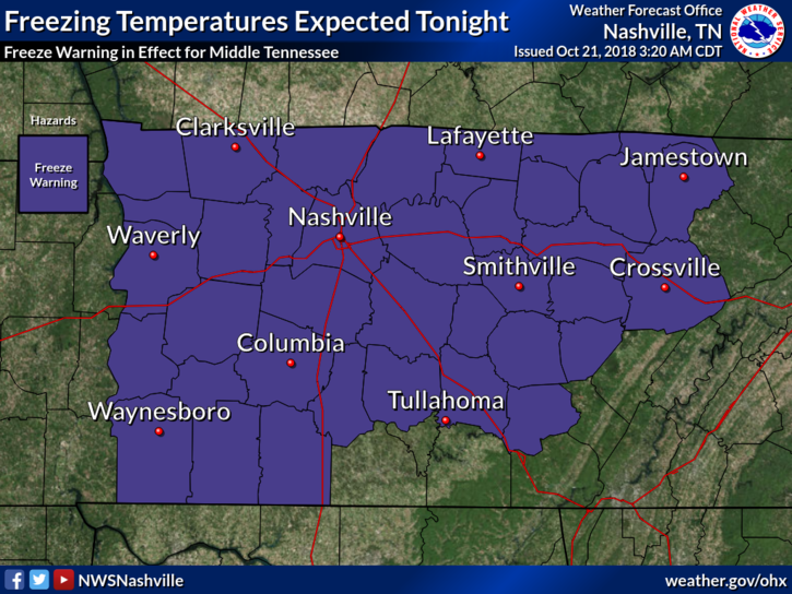
The low is 33° at BNA, 2° colder than last night. Local areas should be colder. Frost is likely with light winds.
Freeze Warning Monday 3 AM to 8 AM, Then Boring Fall Weather; Next Rain Chances
Cover or shelter loved plants and locate your windshield scraper.
The deal with that Saturday night wind
It was a blast of reinforcing cold northern air. During the 10 PM hour winds hit 35 MPH at BNA. They relaxed after midnight and colder air raced in. BNA hit 35° before sunrise.
Dry & Chilly Start to the Week; Rain Chances Gone Until Thursday/Friday
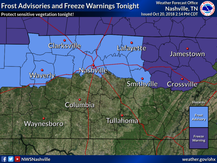
Frost Advisory has been issued for Nashville Tonight
Frost Advisory for Nashville. 33° to 36°. Sheltered and low-lying areas may see frost producing temperatures for at least a few hours prior to sunrise Sunday. A Frost Advisory means that widespread frost is expected. Sensitive outdoor plants may be killed if left uncovered.
Rain to Start the Weekend, Clearing and Cooling Quickly

Cold Front Inbound
We’ve made it to Friday! Much of the day will be clear with temperatures in the mid to upper-60s. Clouds will being funneling in later this afternoon in advance of a cold front that is set to come through tomorrow. With those clouds, come rain chances.
Clear and Dry Today; Rain Arrives Tomorrow Evening, Ending Saturday; Dry and Chilly Sunday
Rain today? High pressure bubble says, “no.”
A ridge of high pressure is now settled right over the Midstate, keeping clouds at bay and squashing any rain chance for our Thursday.
High temps today will remain into the low 60s. Dewpoints in the low 30s! That means the gross-humid weather is out for the day!
Clear Today and Tomorrow, Rain Chance Friday Night
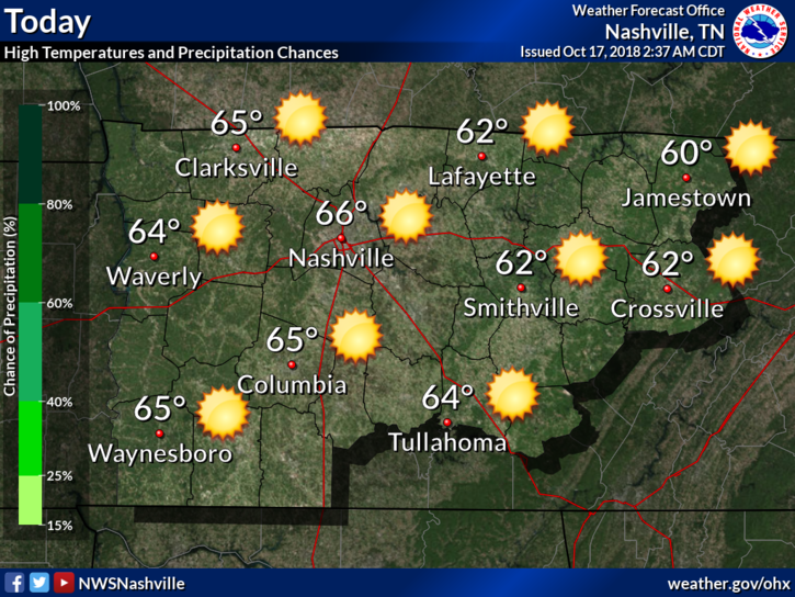
This Afternoon
Fall is finally starting to settle in, in middle Tennessee!
We are going to continue the pattern of below average temperatures today with highs getting into the lower to middle/upper 60s. As of 3:00 pm, we’re at 68°, pretty close to the average high for this time of year, which is 69º.
Light Rain Ending Tonight; Wednesday & Thursday in the Clear; Rain Returns Friday (probably late)
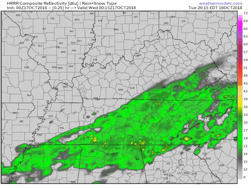
Light rain arrived mid-afternoon, on time, mostly south of I-40. From NWS-Nashville:
Expect most of the measurable rain to be south of I-40, with perhaps a hundredth or two falling in the Nashville area . . .
Colder!
First, this happened today. Apologies to anyone who read all 100,000 of these.
This is our 100,000th tweet. Below is tweet #1 from August 10, 2009.
Nothing has changed. https://t.co/naWEDdh6YP
— NashSevereWx (@NashSevereWx) October 15, 2018
You must be logged in to post a comment.