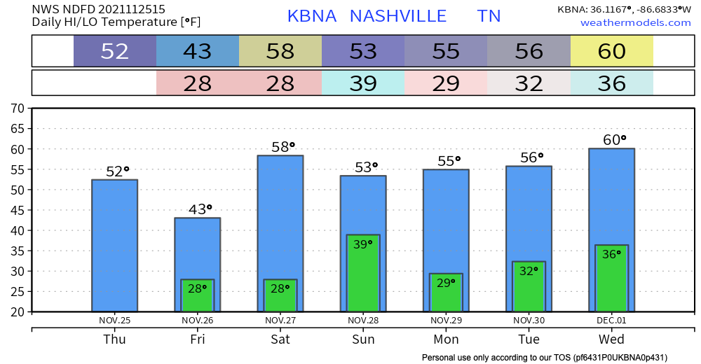
The rain is here, obviously. Off and on, light, and gross looking outside for the rest of the day.
Wind, rain and cold temps aren’t the best mixture so any outdoor plans for today are pretty much a gotta really want it.

The rain is here, obviously. Off and on, light, and gross looking outside for the rest of the day.
Wind, rain and cold temps aren’t the best mixture so any outdoor plans for today are pretty much a gotta really want it.
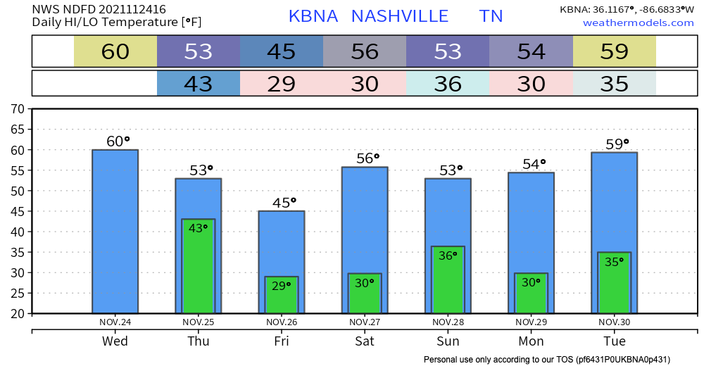
Temps look like they will climb to 60 degrees today, so not as chilly as yesterday. The lows tonight won’t get down to freezing temps.
No rain in the forecast today. Looks like it’ll be a really nice fall day.
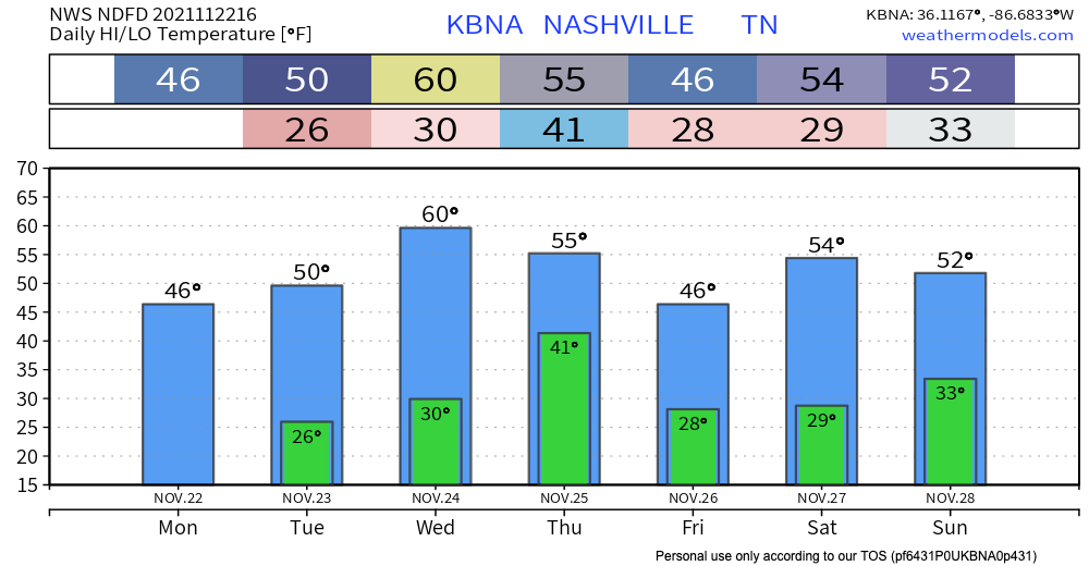
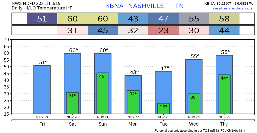
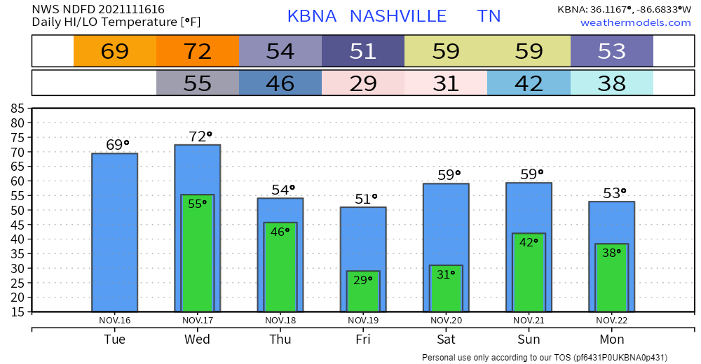
Slightly warmer today with highs right around 50 degrees. Lows tonight could get below freezing, especially if you factor in wind chill. Warmup tomorrow to the upper 50s (if not 60s). Back down to low 50s Thursday and freezing temps possible again in the overnight. Here’s a look ahead at how it’s going to feel through Thanksgiving Day (these are wind chill numbers, not actual temperatures):
The sun is out but yeah, it’s chilly.
Tonight and overnight expect the coldest overnight lows of the season – definitely bring those plants in or cover them, and make sure pets are taken care of as these temps will drop below freezing.
Showers don’t move out until after 9 PM.

Following the cold front, temps plummet. Monday’s high will be in the mid 40’s with the low hovering around freezing. Temps will climb heading into midweek, but it’ll still feel chilly.
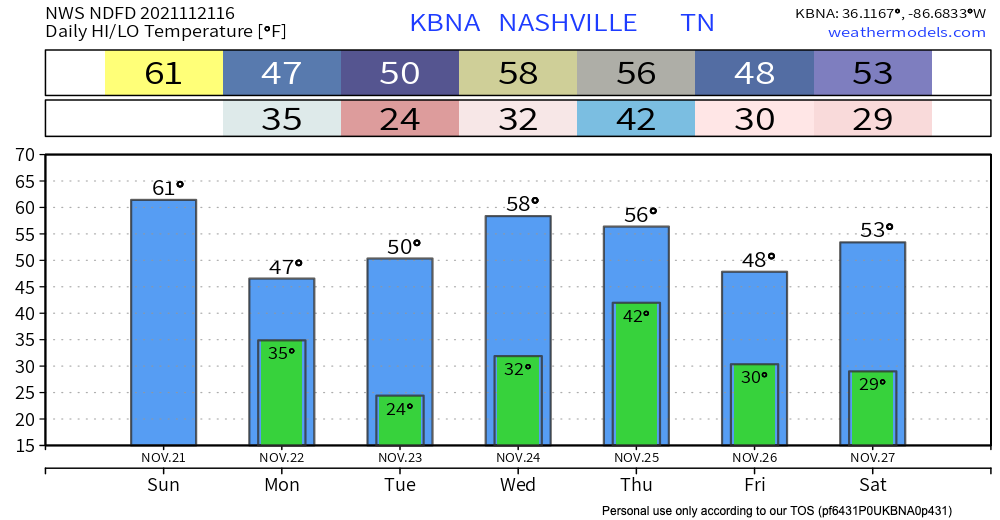
Temperatures will get up to around 60 today thanks to a warm front that moved in last night. Tonight, lows will be in the lower 40s.
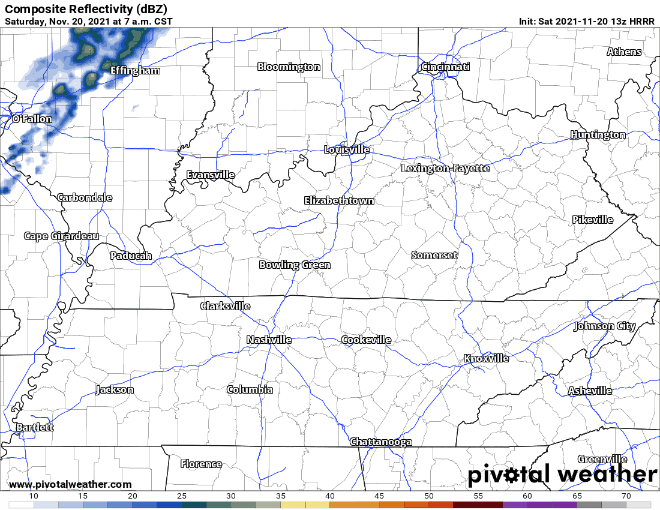
The HRRR (above) shows there will be no rain today. It will be mostly cloudy.
Tonight, overnight lows could dip back into freezing temps. Clear skies giving way to more clouds overnight.
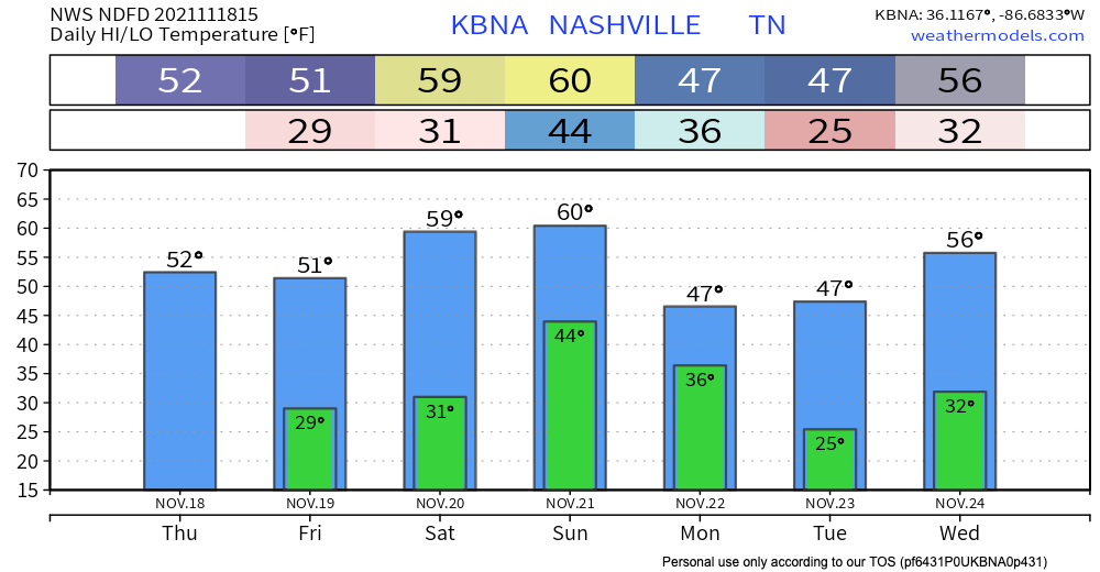
We can expect a warmer Saturday and Sunday, but another cold front will be making its way through our area Sunday, bringing rain. GFS shows rain for most of the day. More specific timing as we get closer.
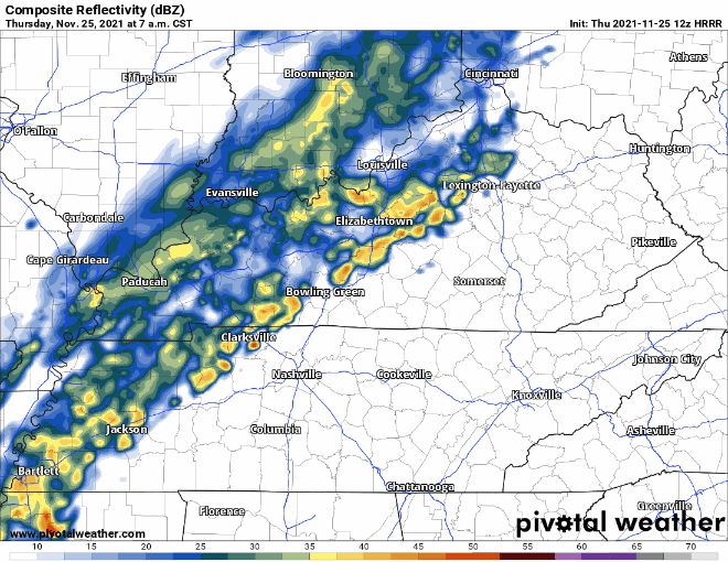
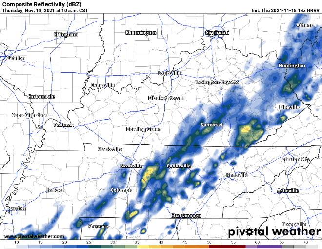
Rain is still lingering from a cold front that passed through this morning. No concerns at all for anything severe. We should clear out right around lunchtime. See HRRR below:
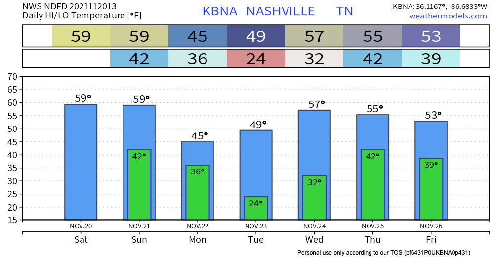
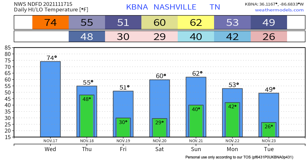
This cold front is living up to its name though. Yesterday’s high was 74, but today’s is only 55.
Warm today with temps creeping up to the mid 70’s and wind gusts up to 30 mph. A cold front passes through early tomorrow morning. HRRR has sprinkles in our counties starting around midnight with the bulk of the system starting around 2am. Heaviest rain is overnight. Leave a tad early tomorrow as the rain persists during the morning commute. Showers move out by 11am. No severe weather is tagging along.
A warm front that passed through this morning. Result: overcast and warmer. Highs today hover around 70. There’s a chance of a light sprinkler here and there, but the real rain comes late Wednesday night, probably Thursday.
You must be logged in to post a comment.