Warming Trend Starts Today

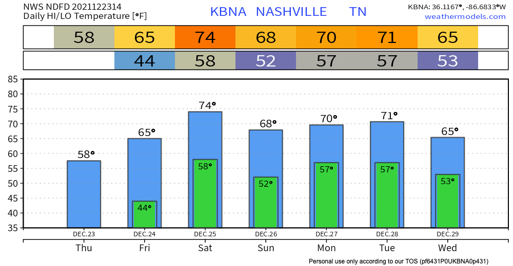
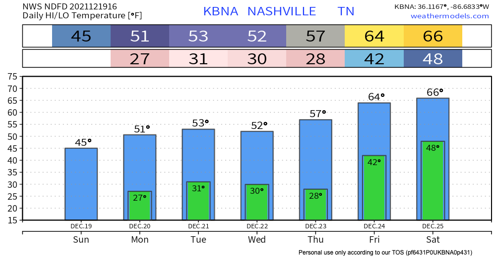
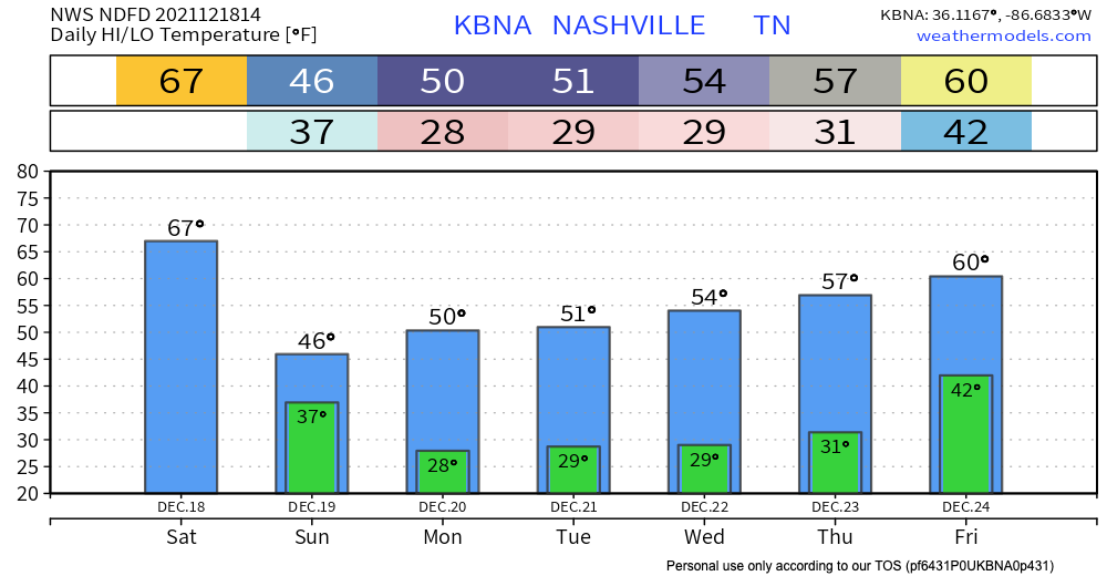
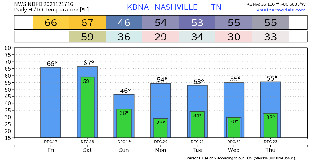
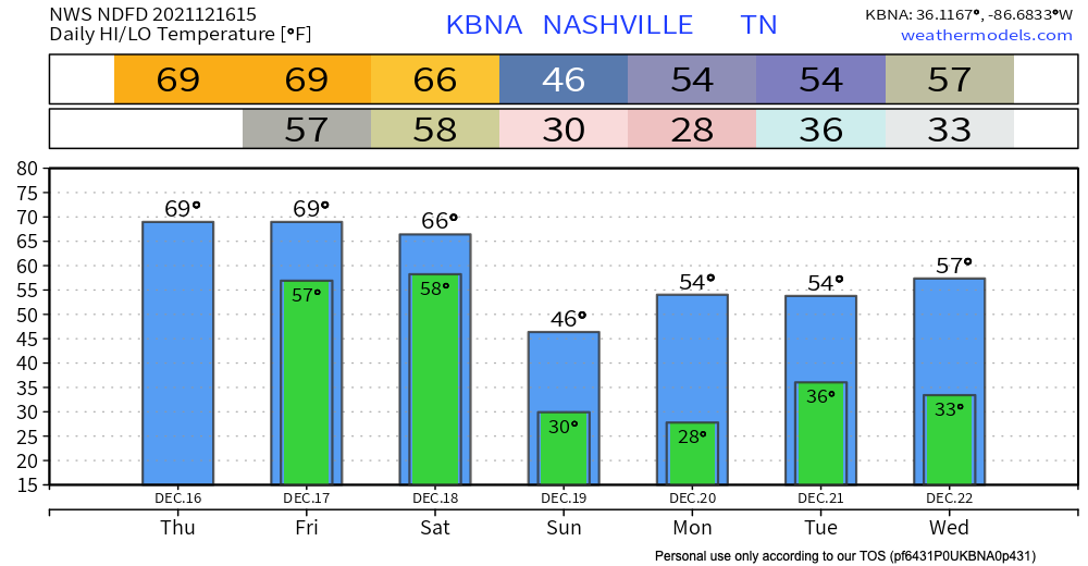
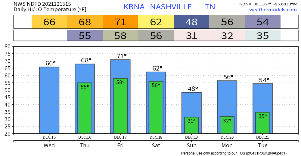
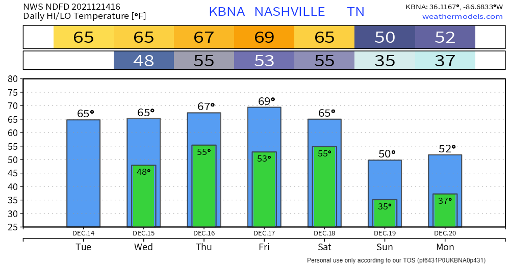
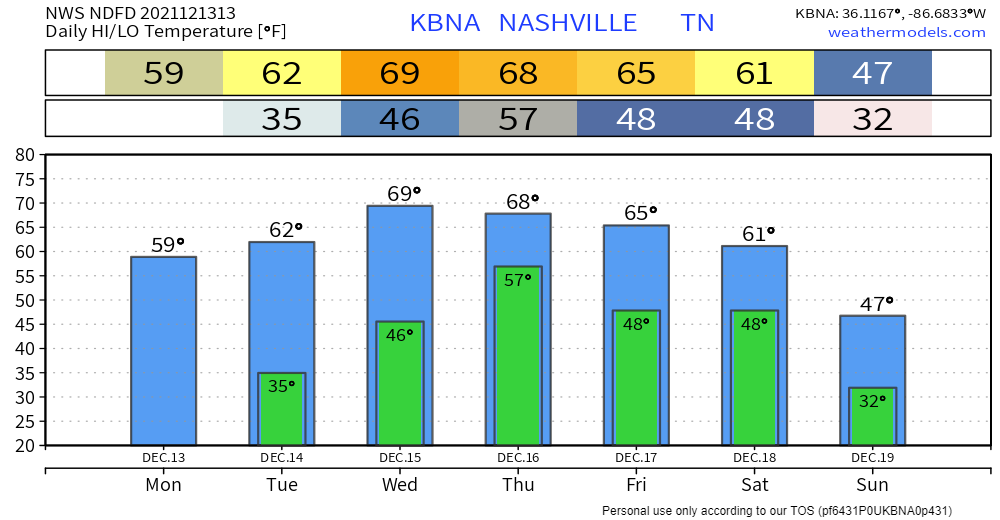
Who’s ready for a warm Christmas. Despite dropping below freezing last night, our warming trend starts now and is expected to stay until the end of the year.

Our highest recorded temperature for December is currently 79 degrees, and we are expected to come fairly close to that on Saturday. Maybe Santa will bring us a new record. read more

Cooling Off Till Wednesday; Dry Christmas As of Now

A cold front comes through our area today bringing a slight cool down. Highs in the low 50’s today drop down to just below freezing tonight. Wednesday is our coolest day this week with temps not getting out of the mid 40’s. Overnight lows are quite crisp in the mid to upper 20’s. read more

Chilly + Dry Today; Some Christmas (Eve?) Rain (maybe)

Normal temps, some sun. Wind chills drop tonight, time stamp upper left:

NWS Blend of Models Wind Chill values, valid Mon. 10am – Wed. 12am

Additional moisture rolling in tonight plus near freezing temps equals a low probability chance of freezing fog early tomorrow morning. If you are out really early and see fog on the road ahead – especially on bridges and overpasses – a thin layer of ice may have formed on the road. The potential hazard will be brief. Just be aware. It’s freezing fog szn. read more

Feels Like December Again; Dry Week Ahead

The warm temps are gone, and the cold blast is here. Highs in the low 40’s today. Temps will dip into the high 20’s overnight. Mother nature has decided it’s December again.

Is It Cold In Here Or Is It Just Me GIFs - Get the best GIF on GIPHY

If you enjoy these cold temps, enjoy them while they last. Temps climb all week. 50’s through Thursday, but then mid 60’s over the weekend. Christmas is supposed to be warm, right? read more

Warm and Light-Rainy Today, Cold Blast Begins Tonight

Rain will be off and on today. It’s coming in from Arkansas (where rain is a bit heavy, with a few thunderstorm), but as it moves toward us the storms will dissipate and the rain will break up into light rain, turning off and on. Temperatures will be in the upper 60s. read more

Rainy Morning, Then Scattered Showers

It’ll be a rainy start to our Friday, but the meat of this system will be out of here by early afternoon. Following that, we will see some scattered showers throughout the day – nothing severe and the flood threat is low. Instability is present, so one or two stronger thunderstorms are possible. The biggest threat in this case would be lightning or strong winds. read more

Latest Tornado Tracks; Rainy Start To The Weekend

Our local National Weather Service office has completed surveys in Davidson County following the storms early Saturday morning. See the map below for the survey results on the four tornadoes that impacted parts of Davidson County Saturday morning. read more

Dry Today, but A Wet Couple of Days Ahead

We stay dry and experience above average temps today getting into the upper 60’s. A wet couple of days are ahead, although we don’t think everyone will get rain non-stop all weekend. Thursday scattered showers and possible thunderstorms start in the afternoon. These are not expected to bring severe weather. Quick downpours can cause some potential flash flooding. WPC is forecasting a 5-10% chance of flash flooding occurring within 25 miles of you. So, keep an eye on the possibility of flash flooding becoming a problem if you live in a flood prone area. read more

Rain Begins Thursday

Clear skies today with temps about 15° above average. Not much different tomorrow. Cloud cover tomorrow will keep temps much the same.

It’s going to get even warmer later this week.

Showers still in the forecast beginning Thursday. Euro model likes our chances of on/off rain showers starting Thursday afternoon through Friday morning. read more

Warm-up Starting Today; Rain Thursday

NWS-Nashville has teams in the field again today. They are surveying damage, distinguishing straight line wind events from tornadoes, and rating tornadoes on the EF scale. They’ve counted 7 tornadoes in Middle Tennessee from Saturday morning. We think that number will probably be higher. Tornado surveys will probably not conclude until Tuesday. We will bring you that information as it comes in. read more