Rain Coming in Wednesday Morning + Possible Freezing Rain Thursday Night

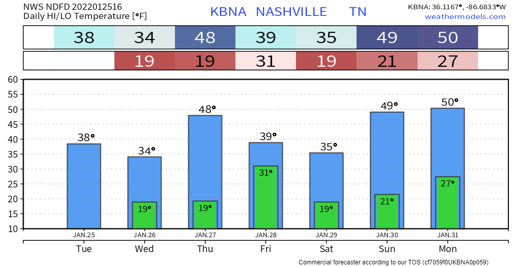
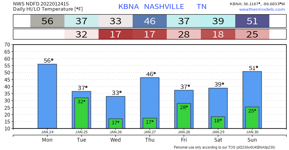
We enjoyed some really nice temps today with a high of 67° and plenty of sun. But…

Mid-Week Rain

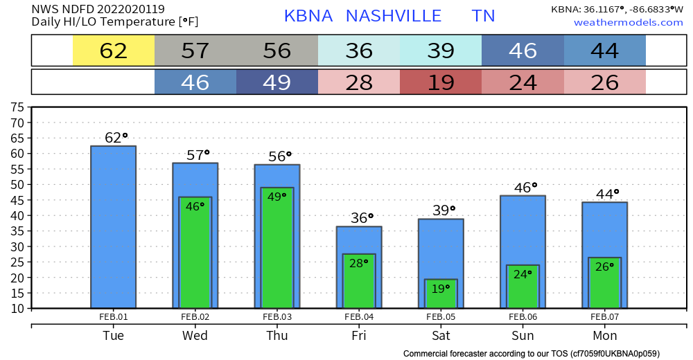
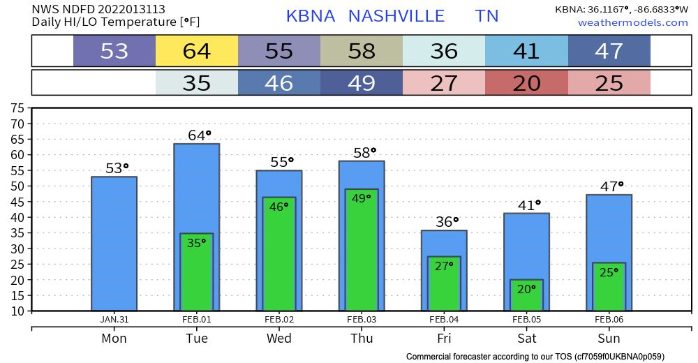
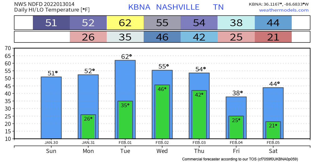
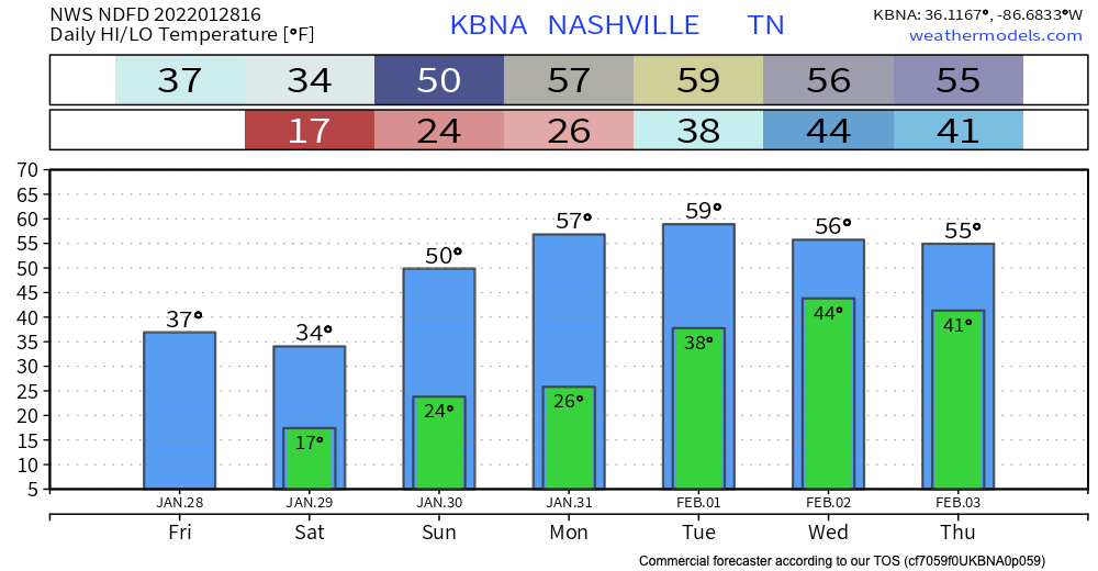
Temps stay in the mid 50’s for Wednesday and Thursday. Low pressure starts to come into our area bringing rain early Wednesday morning. Sustained winds Wednesday ramp up to 20 mph with gusts <30 mph. Showers continue but are spotty Wednesday afternoon to evening time. read more

Mid Week Heavy Rain with Wintry Precip Potential

Temps right around normal today will heat up to the low 60’s by tomorrow.

Rain should begin as early as Wednesday morning. but it’s more likely to start Wednesday afternoon. Rain should be heaviest after midnight Wednesday and into Thursday morning. Rainfall rates should be high, totaling 3″ to 4″ by Friday morning. It looks like rain will be spread out long enough to enable runoff and drainage, but local creeks, streams, and low lying areas should rise. Flooding concern is there, and will be watched closely, but the concern is not high right now. Those in flood prone areas should continue to monitor. read more

Mid-Week Heavy Rain, Wintry Precip Potential Thursday

WARMER

High temps in the 30’s are a thing of the past. We should reach into the lower 50’s today.

Winter Go Away Sparkles GIF - Winter Go Away Winter Sparkles - Discover &  Share GIFs

HEAVY RAIN

Rain begins Wednesday and runs through most of the day Thursday. Here’s the GFS model: read more

Cold and Clear

No rain today! Enjoy the sun but don’t let it deceive you because it is cold. The HRRR is not showing any showers today. The high will be around the mid 30’s, lows in the mid 20’s. The wind chill may effect the temperature feeling. read more

Light Snow Possible

Today we will be seeing some snow, but we aren’t expecting anything major. Some areas may see a light dusting of snow, but you won’t need to do any shoveling.

The HRRR shows very spread out precipitation, so it’s possible that your family doesn’t see any snow or rain, but your coworker across town does. The biggest threat with this system is the frigid temperatures we will see tonight. With wind chill included, we will have temps in the teens. Nearby areas might get even colder and see some single digit temperatures. Make sure the three P’s are taken care of – plants, pets, and pipes. read more

Flurries Tomorrow

Pretty average day for January temp-wise with highs in the upper 40s. More cloudiness throughout the day ahead of tonight’s cold front. And then temps drop back down tomorrow. Wind chill looks no fun: read more

Shockin’ Door Knobs Kind of A Day

Mid 30s the high today and llllow humidity. If you’re one of those people who cringe before you touch a door knob this time of year, today’s one of those days. Expect temps in the teens again tomorrow morning. Wind chill won’t be as much of a factor thanks to lighter winds. Still cold. Even for January. read more

Cold + Dry For a Few Days

Front is in and out. Cold temps and REALLY dry air are what’s left. Highs this afternoon in the upper 30s, overnight lows in the upper teens. Won’t get too far above freezing tomorrow. Wind chills definitely won’t thanks to winds out of the north. read more

Friday: Frozen Precip?

Today will be the warmest day we will see for a while.

Us too Michael, us too.

After reaching the mid to upper 50’s today, we won’t see temps above the mid 40’s until Sunday. A cold front moves through early Tuesday morning bringing cooler temperatures. Overnight lows past Tuesday won’t get above freezing. read more

Few Flurries Possible Tuesday Morning, No Worries

A few flurries are possible Tuesday morning. You can see them at the end of the 12z HRRR model run.

I’ll tweet the 18z run when it comes out in a few hours. Think these will be inconsequential if they happen at all — the precip isn’t on other models. Surface temps should be at least 3° (probably more) above freezing. Splat:Melt. No party, no worries. read more