Flash Flood Watch Through Noon Tomorrow, Heavy Showers Tonight

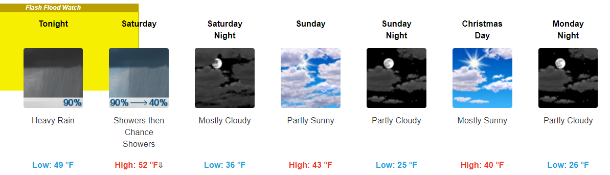
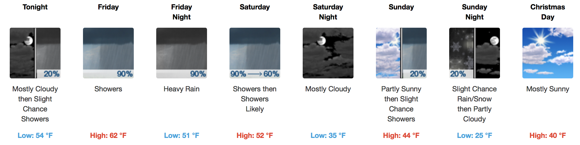
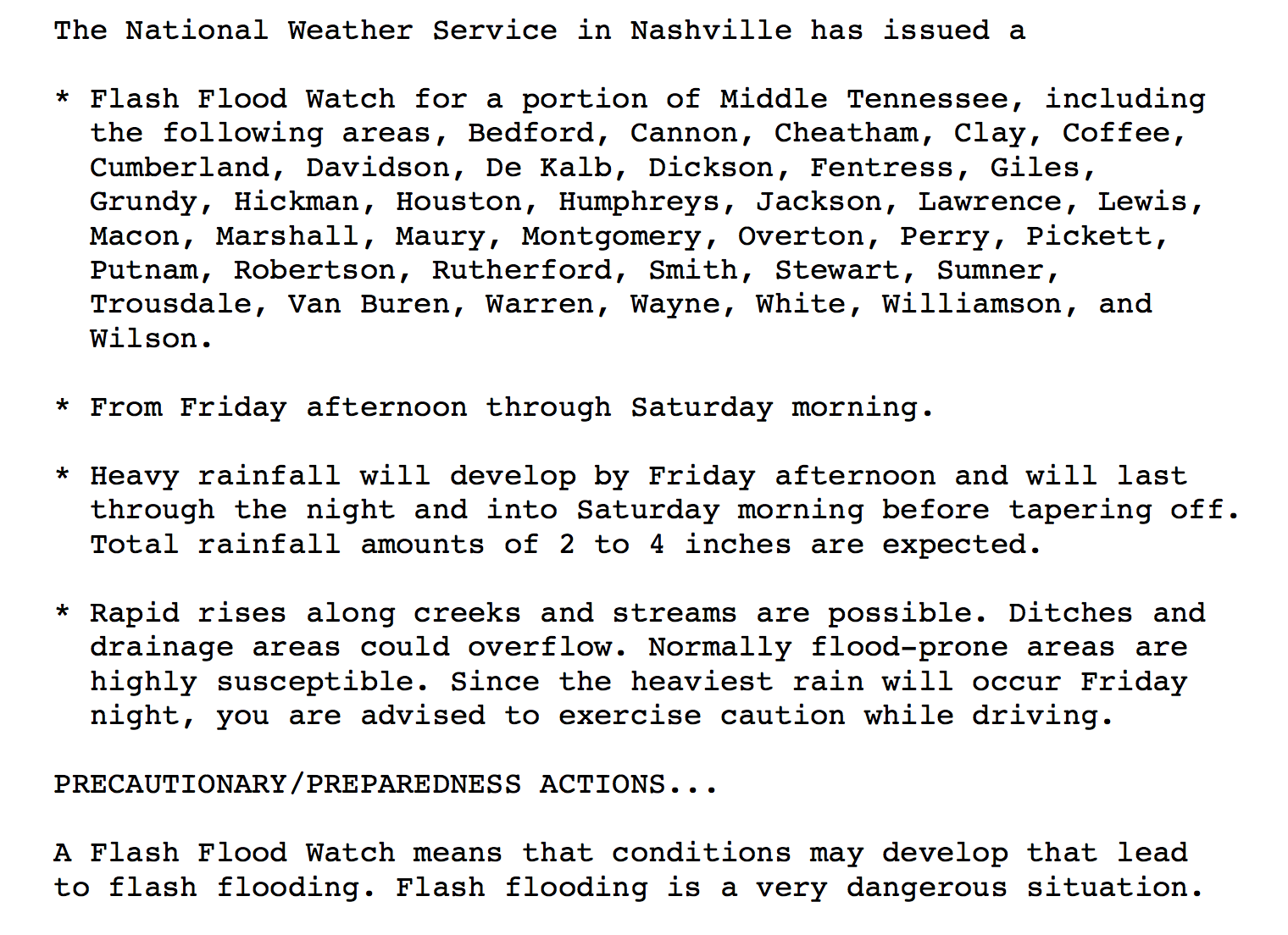
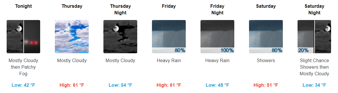
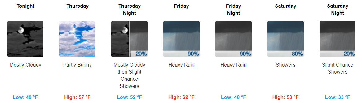
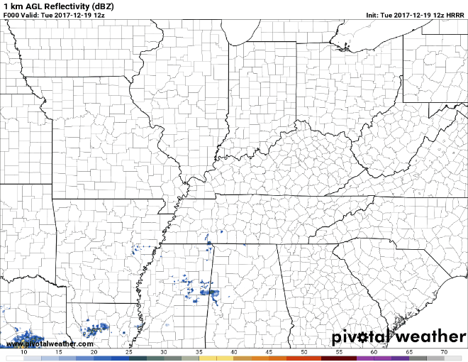
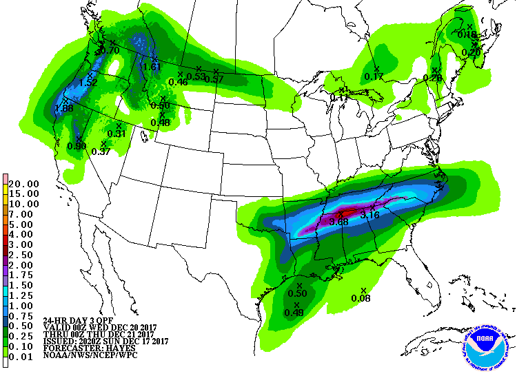
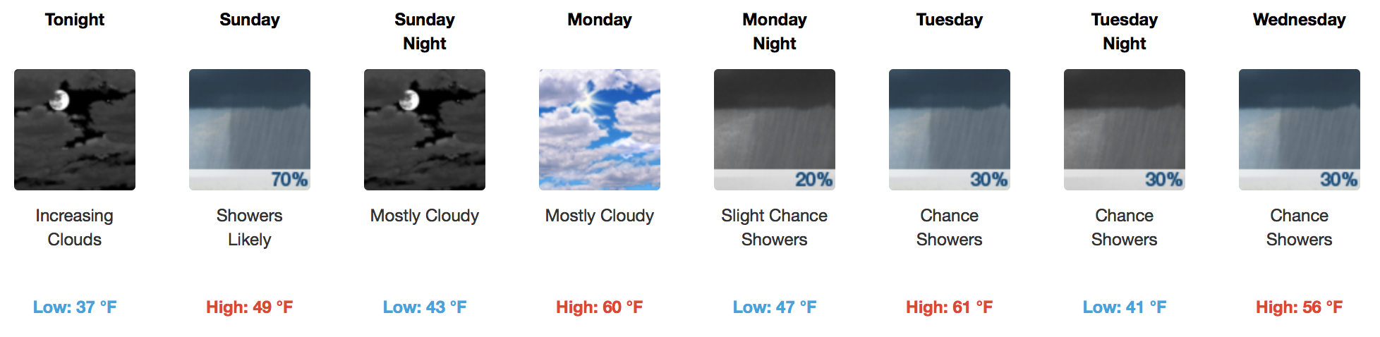
Rain Continues, Heaviest Rainfall This Evening into the Overnight Hours

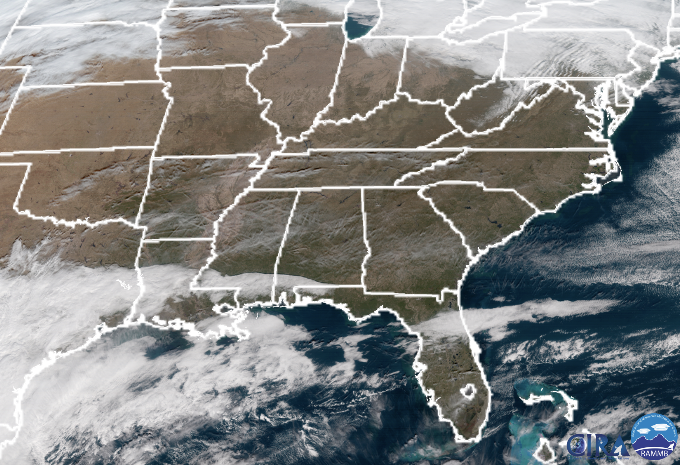
Bands of showers continue to push through Middle Tennessee with heavier showers on the way later tonight.

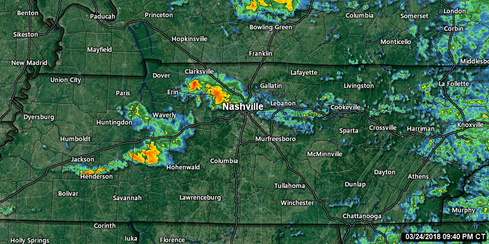
For real-time radar & updates: https://nashvillesevereweather.com/realtime
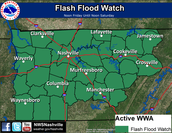
Hazards:  read more

Flash Flood Watch Issued, 3-4″ of Rain Anticipated

Lots of Rain On the Way, Flooding A Concern

Since writing the blog this morning, NWS Nashville has since gone ahead and issued a Flash Flood Watch for Friday and Saturday:

To provide a general overview of how things are expected to play out, here’s a solution by the latest GFS model: read more

More Showers Friday & Saturday, Keeping an Eye on Flooding Potential

Showers Exiting, Patchy Fog Overnight, Gradual Clearing Tomorrow

The last bit of showers continues to move eastward, leaving us with cloudy skies through the overnight hours. Don’t be surprised if some fog develops overnight. Fog should mix out during the early morning hours. read more

More Showers Today, Even More Friday/Saturday, Cooler Temps Next Week

Scattered Showers Throughout the Day, Clearing This Evening

Fairly dreary day today with showers hanging around through the majority of it. You will want to keep those umbrellas handy.

https://giphy.com/gifs/willandgrace-episode-2-nbc-l1J9rMqPQ8c2HfxiE

Bands of showers will continue to move through Middle TN at least through the afternoon hours. Most models show these showers tapering off as we reach the evening hours. read more

Lots of Rain In the Coming Days, Some Flooding Possible

Rainy Period Ahead, Starting As Early As Tonight

Latest HRRR Model Loop

\

The latest hydrologic outlook from NWS Nashville says it all:

Rain will likely start after sunset tonight and continue through the day on Wednesday. Rain will finally come to an end, but only briefly, early Thursday morning. read more

A Warmer and Semi-Dreary Week Ahead

Patchy Fog Developing Overnight

Mostly cloudy skies expected overnight tonight with temps falling into the low-40s. Do not be surprised if you wake up to some patchy fog tomorrow morning.

Two Rain Makers This Week

Highs look to bounce through the mid-50s to lower-60s through the rest of the week. Wednesday night and Thursday look to be our driest period through it all. read more

Rain Tuesday & Friday, White/Wet Christmas Update (Warning: Forecast Scrooging)

Tonight, Cloudy Drizzly Foggy

Monday, Cloudy, Early 43°, High 58°

Maybe a little fog early.

Tuesday, Rain Late, Heavy Rain Possible, Early 45°, High 60°

Rain should begin Tuesday night.

Southern Middle Tennessee should see the most rain, a real soaker, more than 2″.

It’s possible the models are a bit off and we will see that very heavy rain here. read more

Generally Warmer Temperatures, Chances for Rain This Week/Weekend

Beautiful and Warmer Today, Rain Sunday

Side note: GOES 16 is back as GOES EAST!

Preliminary satellite this morning shows a few passing clouds over Tennessee, but nothing to keep the sun from shining. Temperatures this afternoon will soar into the 50s, a nice warmup for mid December. read more

Cool Today. Temps Begin to Warm Tomorrow Through Next Week

Cool Today, Warmer Tomorrow

On the cooler side of things again today with highs anticipated to only reach the low-40s. Today’s highs will likely depend on the cloud coverage we currently have. Taking a look at the current satellite imagery, we have a blanket of clouds draped over much of Middle Tennessee. read more

Clouds Hanging Around Today, Waiting on Weekend Warm-Up

Cooler Through Friday, Warm Weekend

Clouds will have a difficult time breaking up today, but we may get a few peeks of sunshine in the late afternoon. Our area is behind a cold front, so colder temperatures are filtering in. 20s are expected overnight into tomorrow morning, and we’ll only rebound into the mid-40s Friday afternoon. read more