Saturday Rain Maker, Much Colder Temps Move in Sunday

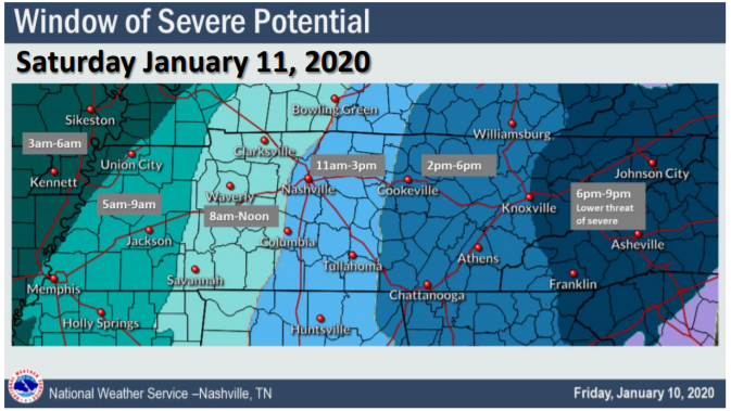
Dry Thursday and Friday

High temperatures today (Thursday) will reach 49°. Winds will be 10-15 MPH with gusts as high as 20 MPH.

Friday will reach 48°. Showers in the afternoon/evening are possible, but we aren’t really counting on them. If we see any, they will be light and brief. read more

Be thunderstorm-aware today.

One weather model, the HRRR, thinks heavy rain and thunderstorms will arrive around 4 PM (give or take a few hours).

The HRRR model thinks these storms may be strong or severe, however, this model may be overstating the severity of the storms (below see HRRR model which expects 1,161 j/kg of surface based CAPE to fuel a pretty big storm or two; this high amount of storm fuel seems unrealistic given the cloud cover, so HRRR may be predicting the storms to be worse than they’ll actually be). read more

More Storms Possible Wednesday Morning. Another Roller Coaster Week Ahead. Cold End to January . . .

The HRRR model predicts storms Wednesday morning around the AM commute, around 5-7 AM:

Other models think morning rain and storms are possible, but prefer to keep them south and east of us. ETAs may vary. read more

Overnight Storms, Small Chance of Hail, More Rain Through The Week

Showers Maybe Storms Late Tonight

No rain today, high 60°.

Rain comes tonight, after midnight. A few rumbles of thunder and/or a downpour might wake you up tonight; hail the main concern. No tornado or strong wind concerns.

Hail up to 1″ in diameter is remotely possible, mainly south of I-40 in the dark green shaded area. The probability of a big ole hailstone falling within 25 miles of those in the green shaded area is 5%. read more

Dry Sunday and Monday; Next Rain Chances begin Monday Night, Off & On thru the Weekend

Sunday and Monday: Quiet

High temperatures today (Sunday) will reach 54° with mostly cloudy skies.

Monday looks the same but with a high of 64°.

This is a nice break after the very windy and rainy weather we had yesterday.

Rain This Week

… and there is no end in sight (just kidding, but it may feel like it). A few active weather patterns look to bring the chance of rain to the area all week. read more

Stormy Start to a Saturday

Quick recap

It has been quite the busy morning at our three locations around Williamson county. We’ve had computers reboot mid livestream, staggering wind and rain, and internet that decided to take a break. But, most of us dodged damage with this line of storms. read more

Tornado Watch Until 1 PM

A Tornado Watch has been issued by the Storm Prediction Center, in coordination with our local NWS-Nashville office.

The Watch expires at 1 PM today.

The Watch was issued to let everyone know an approaching storm line may pack 60+ MPH winds and/or spin up a tornado or two. read more

Saturday’s Storm: a diary, an essay, and some graphics.

Someone’s Diary: The Wind

It’s stupid warm for second week of January but no one wore a skirt today. No one will wear one tomorrow. The wind’s been too strong. Modesty lives.

I saw on Twitter there’s a Wind Advisory for Friday night and Saturday. Winds may gust 30 MPH, 40 MPH, maybe as much as 50 MPH. Those Advisories talk about trees and power but when I see them Hashtag pants, make your daddy proud. read more

A Few Showers And Windy This Afternoon, Severe Weather Information For Saturday

Warm And Windy Friday

We’re going to have on and off rain throughout your Friday afternoon and into the evening hours. Hold onto your hats if you have any plans this evening as winds will continue to gust up to 30-40mph. Here’s the latest HRRR model, not all of us will see rain this afternoon and evening, but some will. read more

Rain Begins Friday, Very Windy 48 Hours Ahead; Heaviest Rain/Storms (Some Possibly Severe) Saturday

Warm & Windy (62°) Thursday

15 to 20 MPH winds with gusts as high as 30 MPH. Secure hats and lightweight aunts.

It’ll be windy Friday and especially Saturday.

Rain Begins Friday, Storms (Strong/Severe Possible) Saturday

WHAT THE MODELS SAY

The GFS model shows light, scattered showers late Friday, with the heaviest rain and storms sweeping through Saturday afternoon: read more