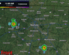
A couple more hours of on/off showers this morning. Nothing too crazy, but you’ll need rain gear for any plans.
You can check the radar anytime on our website here: Radar – Nashville Severe Weather

A couple more hours of on/off showers this morning. Nothing too crazy, but you’ll need rain gear for any plans.
You can check the radar anytime on our website here: Radar – Nashville Severe Weather
Another fairly nice day of weather in store today. Highs still getting into the upper 80s, but dewpoints will remain tame in the low 60s – making it feel tolerable. Can’t totally rule out some showers, especially as we get closer to sunset, but majority of the day will be dry.
Our cooler and drier air has arrived. At 9a, BNA reported a temperature of 72° with a dewpoint of 59°.

This won’t last forever, so get out and enjoy it. Today and Friday will be good days to catch up on yardwork.
A few quick showers will be possible today, especially around WillCo., but these won’t amount to anything.
We finally get a few dry days strung together. Dry Thursday and Friday before rain chances return on Saturday, where some scattered showers/storms look possible. No severe weather expected but can’t rule out a strong storm or two. We’ll keep an eye on things as always. Timing looks iffy, with chances hanging around most of the day. Heads up for those with outdoor plans.
We certainly have plenty of headlines to talk about.
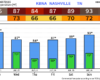
Before the storms, it’ll be a hot one. Our Heat Advisory continues thru 8p. High temperatures will soar into the mid 90s, paired with dewpoints in the mid 70s = heat index values in the 105 – 110° range. Please take precautions against the heat if you have to be outside for long periods of time, including staying hydrated and taking frequent breaks. Heat illness can happen to anyone.
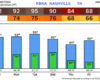
Before we dive into tomorrow, we do have a Heat Advisory to deal with today. Heat index values will be near 105° this afternoon. Be sure to take precautions against the heat if you have the be outdoors for long periods of time, including staying hydrated and taking frequent breaks.
We have three more days of storms to get through before we finally get a pattern change.
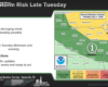
Today (Sunday), will be more of the Wattery (water + lottery) variety. Scattered showers + storms possible thru the evening hours. Not expecting any severe weather today, but we’ll be watching for the possibility of localized flash flooding with any slow-moving or training storms. And of course, any storm could contain lightning, so heads up to those with outdoor plans today – when thunder roars, go indoors.
Good news, models think most of us finally get in a dry day.

While we can’t totally rule out a stray shower or storm, your outdoor plans will likely stay dry today.
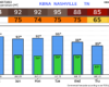
On the other hand, heat index values will creep up towards 105°, so be sure to stay cool and hydrated if you do have plans to be outside for long periods of time.
We continue our Wattery (water + lottery) chances today with some isolated showers/storms possible this afternoon and early evening. Basically a repeat of the past couple days, just with some different placement of the showers and storms. We also have reverted to our typical flow pattern, so no more Crazy Ivans.
Another day, more Wattery chances. This week will be a continuation of our rinse (sometimes literally) and repeat pattern we’ve been in for… a while.
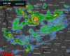
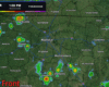
A guess from the HRRR model on what the radar could look like today, which won’t be exactly right, but gives a halfway decent idea. More popup showers/storms, mainly confined to the afternoon and early evening. Although last night we saw we can’t rule some precip out a little bit later as well.