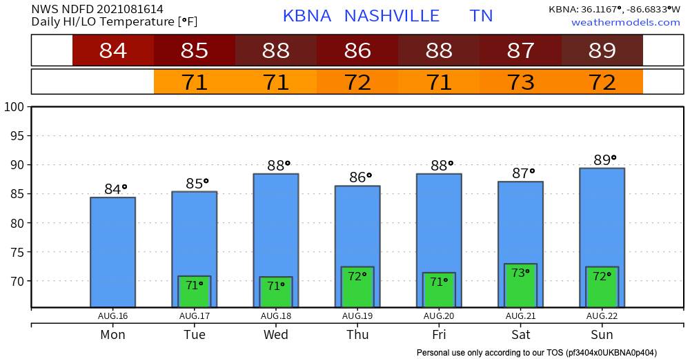
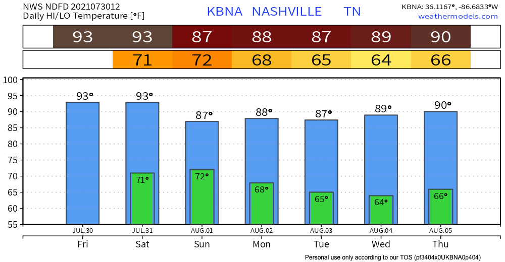
Like yesterday, this morning is very foggy, and tomorrow morning could be as well. Remember to drive carefully if you encounter any dense fog.
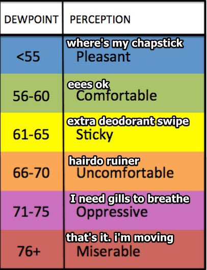
It’ll be another hot and humid day, with dewpoints in the 60s and 70s.

I am a junior broadcast meteorology major with a communications minor at Mississippi State University.
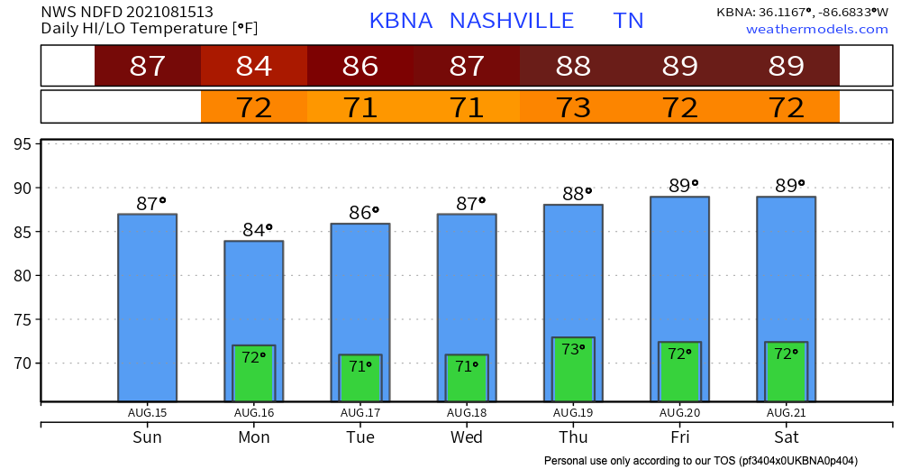
Like yesterday, this morning is very foggy, and tomorrow morning could be as well. Remember to drive carefully if you encounter any dense fog.
It’ll be another hot and humid day, with dewpoints in the 60s and 70s.
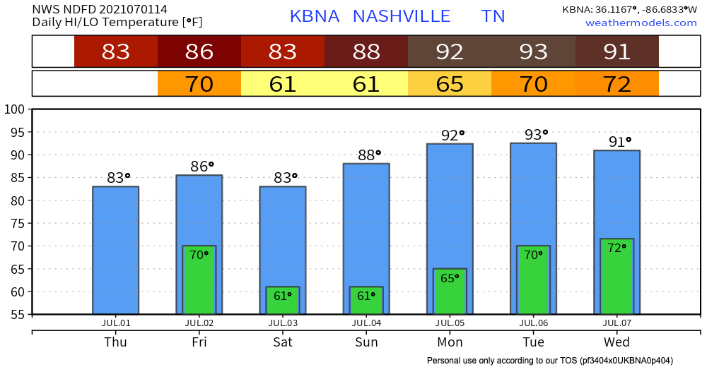
There was fog this morning and there will probably be fog tomorrow morning. Consider printing this graphic and sending it to other drivers. We know you, loyal reader, drive perfect. The problem is other drivers.
First, the rain chances.
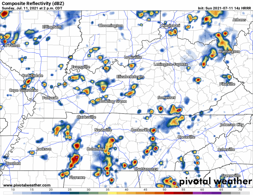
The HRRR shows a clear day for us, with maybe a shower or storm popping up in random spots. Mid 90°s temps with a superhumid (for us) airmass — dewpoints in the low 70°s ugggghhh — is plenty of fuel for a pop up storm. Just going to be hard for one to form today. One clue: if it’s storming close enough to us in Kentucky, an outflow boundary will come flying south into town. That could create showers and a few lightningstorms. We’ll watch this and post updates on Twitter.
Heat index up to 97° this afternoon. Same temps as the weekend but dewpoints over 70° will be to blame for making the humidity worse than it was this weekend.
A system of storms will be going through to our north, which could maybe bring us some pop ups in the afternoon/early evening, but it isn’t looking super likely.
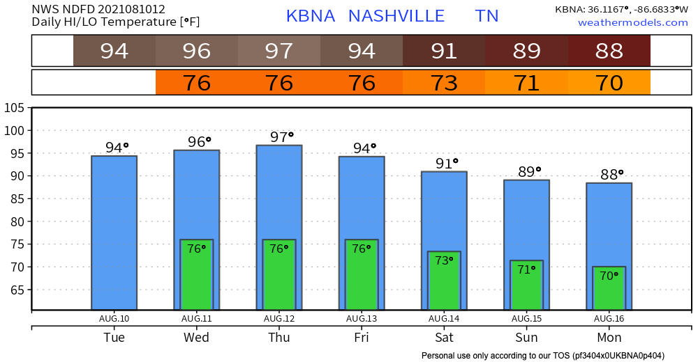
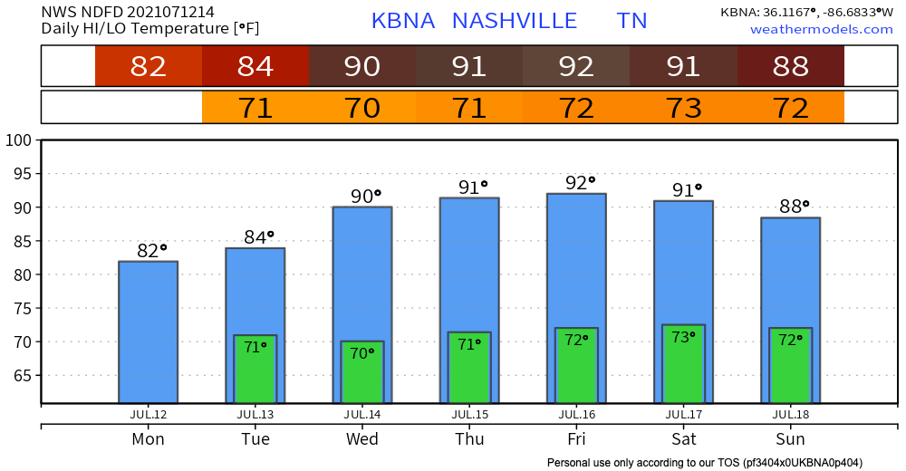
This warmest low temperature of all time was likely recorded today at BNA. 80º. If we don’t drop below 78º before midnight tonight, we’ll have a new official record. Whether it stands or not, an 80º low temperature is highly unusual.
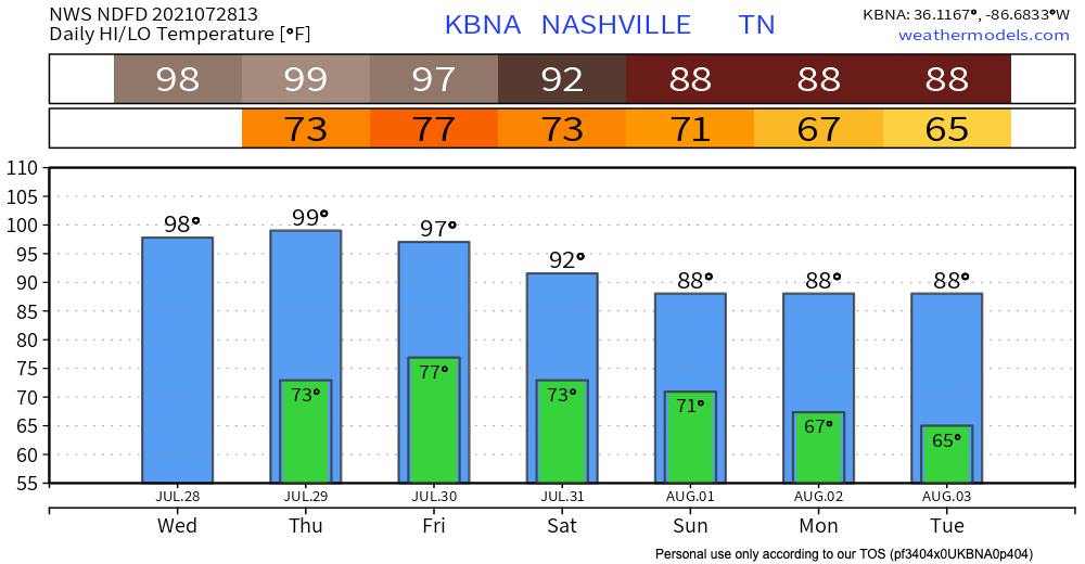
If I were to put “summer” in all caps, bold, underline, and italics, that’s what today will feel like. SUMMER. Heat index will almost reach 100, there is pretty much no chance of rain. At the time of writing this, we are not predicted to reach the heat index needed to issue a heat advisory (105), but we are very close. Highs in middle TN will vary in the 90s, and Nashville could hit 98.
The low pressure system stuck in the Mississippi Valley will continue to bring the region stormy weather today. But will you get it? Depends on exactly where you are.
This is one of those days where Joelton, Franklin, and BNA get storms, but no one else. Or Fairview-Bellevue-North Nashville-Skyline-Goodlettsville get stormed. You get the idea.
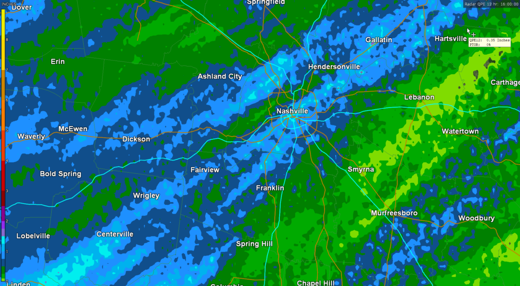
More than 1″ fell early this morning per MRMS estimates.
More downpours and storms are possible this afternoon and evening. The HRRR sure thinks so:
Lightning, gusty winds, and heavy rain are the hazards with this. Water sports and other outdoor stuff away from enclosed shelters are most vulnerable today. Hail and tornado are not in the forecast, but we think tiny hailstones are possible should an updraft get particularly strong.
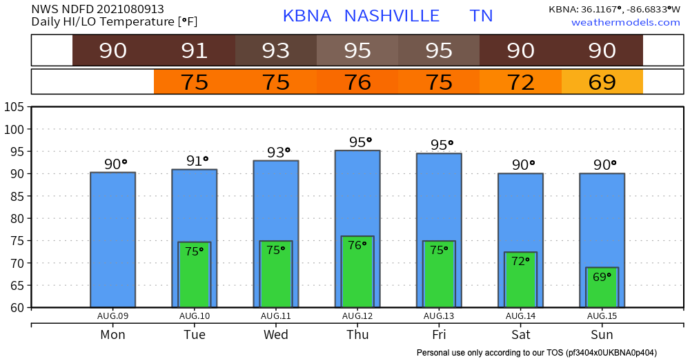
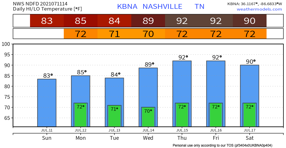
Today, temperatures and dewpoints will rise back to what’s expected for this time of year. Expect dewpoints in the upper 60s.
Heat index will be in the mid 90s, so make sure to hydrate and use sun protection!
We have good news and bad news. The good news is, a cold front is coming through, so there will be lower temps and sunny skies. The bad news is we have to get through some rain before those cooler temps and sunshine arrive.
You must be logged in to post a comment.