Cold but Dry Weekend

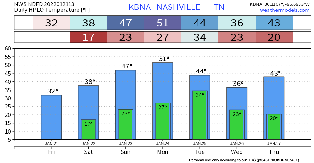
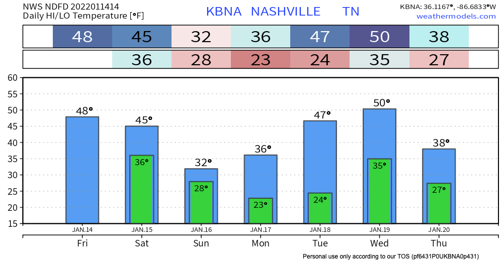
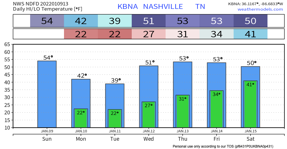
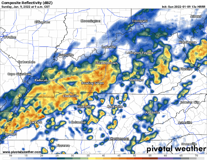
It is definitely going to feel like winter out there today. Grab your hats, scarves, fuzzy socks, and gloves cause it is capital C Cold today. Temps will be in the 20s and 30s. This combines with the wind coming from the north, giving us some wind chill values in the teens. Here’s what that looks like on the HRRR. Blue is very cold, purple is very very cold. read more

Latest On Weekend Winter Storm

Computer models are lacking consistency. Cold stuff will definitely be falling from the sky but we don’t know exactly what, where or how much. But, we have a forecast. Here we go:

A winter storm watch was issued this morning starting Saturday at 6 pm through Sunday at 6pm. read more

Rain Today, Icing Overnight?

HEAVY RAIN

We’re starting off our Sunday with some rain. HRRR model:

We are not expecting anything severe, but you might see some heavier rain or hear some rumbles of thunder as this cold front moves in. The biggest threat? Localized flooding, but this is a low probability hazard. read more

Very Cold Today, Rain and Melting Saturday

After yesterday’s record breaking snow, last nights extreme cold, and today’s below freezing temps, you can expect the snow to stick around today. Unless your car has ice skates instead of wheels, AVOID DRIVING IF POSSIBLE!! The roads are still very dangerous and icy. If you absolutely have to drive, make sure to go very slow and leave plenty of room between you and other cars. Don’t make sudden movements. Also be sure to bring extra warm clothes, food and water in case of emergency. read more

Snow Thursday: Travel Problems Possible

Put very scientifically by NWS-Nashville: “Yep, looks like old man winter will be taking another swing at the mid state on Thursday.”

Middle Tennessee, in general, can expect this:

Timing remains iffy right now because we only have the lower resolution global models. Those models are the GFS and Euro. Both show a big blue blob (snow) moving through starting Thursday around 9 AM and lasting into early evening Thursday. Again, timing does not appear at all solid. Remember the above slide that says “Event is still 2 days away and forecast will likely change.” We will update you on changes on Twitter and in future blogs, as needed. read more

Severe Storms and Heavy Rain Possible Through Saturday Night

This morning we’ll be seeing some scattered showers around the area, which should clear out before lunch time.

Later into this evening, some heavier storms will make their way through. The HRRR currently has the rain moving in around 8pm and sticking around through that New Years toast. This unfortunately means outdoor parties are a no-go. Probably going to be hard to shoot fireworks in the pouring rain. read more

Warming Trend Starts Today

Who’s ready for a warm Christmas. Despite dropping below freezing last night, our warming trend starts now and is expected to stay until the end of the year.

Our highest recorded temperature for December is currently 79 degrees, and we are expected to come fairly close to that on Saturday. Maybe Santa will bring us a new record. read more

Rainy Morning, Then Scattered Showers

It’ll be a rainy start to our Friday, but the meat of this system will be out of here by early afternoon. Following that, we will see some scattered showers throughout the day – nothing severe and the flood threat is low. Instability is present, so one or two stronger thunderstorms are possible. The biggest threat in this case would be lightning or strong winds. read more

Severe Threat Tonight

This blog describes to you, fellow neighbor, a low probability of a high impact event. Basic precautions are necessary.

  • Have a way to be alerted. Get your NOAA weather radio (Midland, Reecom are among the best) and a wake me up app, like StormWatchPlus or any other you like.
  • Understand severe weather terminology and have an action plan if a warning is issued.
  • Mobile and manufactured home residents without instant access to an underground community shelter should consider spending the night in a safe structure.
  • For most of today, expect on and off showers. A warm layer of air aloft (called “the cap”) is present, limiting severe development during the day. There’s no severe concern during daylight hours.
  • Storms after dark can develop, mature, go severe, and even drop a tornado quickly; they’ll be fast moving. This may not leave you much time to get to your lowest level, interior room.
  • There are still some uncertainties regarding the degree of severe weather risk and timing.” That’s a quote from NWS-Nashville. Keep that in mind while reading the below info.
  • Stay connected to updated information. It’s possible we just get wind and rain, and that’s all. Or, some of us may see a severe weather event. Probabilities are below. Note that those are probabilities of hazards within a 25 mile radius of you, not the probability of you getting hit.

Now Until Dark

Windy, 15-25 sustained, with gusts to 40 MPH. A Wind Advisory is in effect today (expiring at midnight). read more

Spotty Showers Tonight, Prepare for Severe Weather Friday Night/Saturday Morning

Starting late tonight, our weekend weather maker will start moving into our area, starting off with some spotty showers.

These showers will hang around all day Friday, but they are pretty spread out. You might get a lot of rain, but your coworker might not. Some of these individual cells also could be strong enough for some thunder and lightning, but we aren’t expecting anything severe quite yet. read more