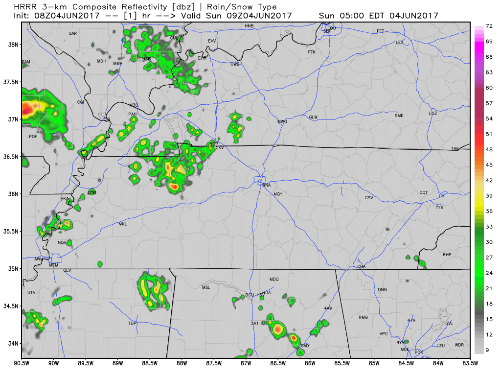
This morning, NWS-Nashville wrote “Today through late Monday…the mid-state expected to remain in deep moisture regime…with a series of upper impulses passing …and with a few weak low-level boundaries in the immediate vicinity.”

This morning, NWS-Nashville wrote “Today through late Monday…the mid-state expected to remain in deep moisture regime…with a series of upper impulses passing …and with a few weak low-level boundaries in the immediate vicinity.”
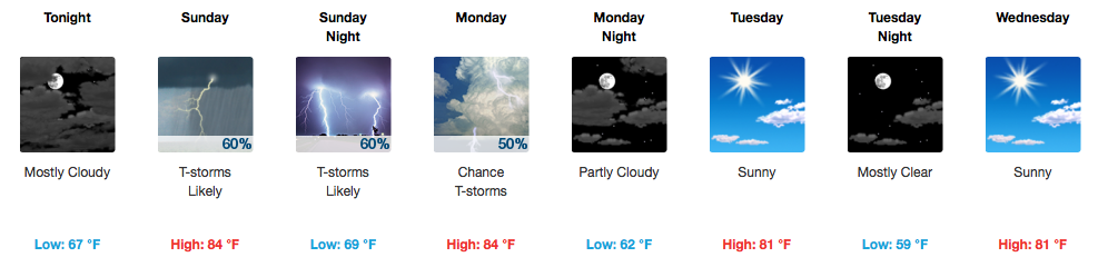
Clouds will start to push in this evening, and temperatures will fall into the lower 80s/upper 70s by 9PM.
[av_textblock av_uid=’av-lkhyzb’]
[cjtoolbox name=’Testing HTML 1′]
[/av_textblock]
To quote our local NWS:
“Warm and humid. Those are the two words of the day.”
https://giphy.com/gifs/june-gym-conundrum-QV5vp1BYenfCE
Lucky, we have remained shower-free this far. There is still a small chance that a shower could develop given the amount of moisture present, but since none have developed so far, that chance is very small. If a shower does develop, it should quickly diminish in the early evening.
UPDATE: There are a few thunderstorms sagging southward towards Davidson County. Will these make it here? Time will tell. They are taking their sweet time. We’ll be following their progression, and post-sunset dissipation on Twitter @NashSevereWx.

So far, we have remained dry throughout the day. Hopefully this will continue through the remainder of the afternoon.
For those with evening plans, if any showers do develop, they will diminish once the sun goes down.

Showers and a few storms are expected once again on Wednesday as a frontal boundary approaches middle Tennessee. The GFS paints a picture of rain while the NAM is very shy on placing any rainfall over our area. NWS Nashville is leaning towards the chance for rain rather than not at all, and some of these showers/storms could contain gusty winds and small hail.
It’s Memorial Day. As long as we’re doing this, we will remember Army Spc. Jason K. Edens. We remember him today.

He was born in Nashville. He graduated from Franklin High School in 2007. After a few semesters in college, he joined the Army then married Ashley. Assigned to the 1st Squadron, 13th Cavalry Regiment, 3rd Brigade Combat Team, 1st Armored Division at Fort Bliss, Texas, he was deployed to Afghanistan in the fall of 2011.

Memorial Day looks much better with highs in the mid 80s, dry conditions, and plentiful sunshine. Small storm chances exist Tuesday and Wednesday, with a better chance for thunderstorms Friday into next weekend as a front stalls out nearby.
…but the threat for Davidson/Williamson Counties is dwindling quickly. Technically, we are under a severe thunderstorm watch until midnight; however, *a majority* of storms are expected to stay from Williamson county and points south. Regardless, rain and thunderstorms will make for some noisy zzz’s. We’ll keep an eye on any rogue storms that go severe on Twitter @NashSevereWx. If you have damage reports, send a tweet using #tSpotter with the typical “what, where, when” format.


Probabilities (high wind threat)

Note: “PDS” is a tag used to indicate a very high threat for certain criteria, in this case damaging winds.
Stay tuned to @NashSevereWx on Twitter and multiple media outlets as thunderstorms impact our area. Use #tSpotter on Twitter to send in your storm photos/reports, only if you are able to do so safely!
You must be logged in to post a comment.