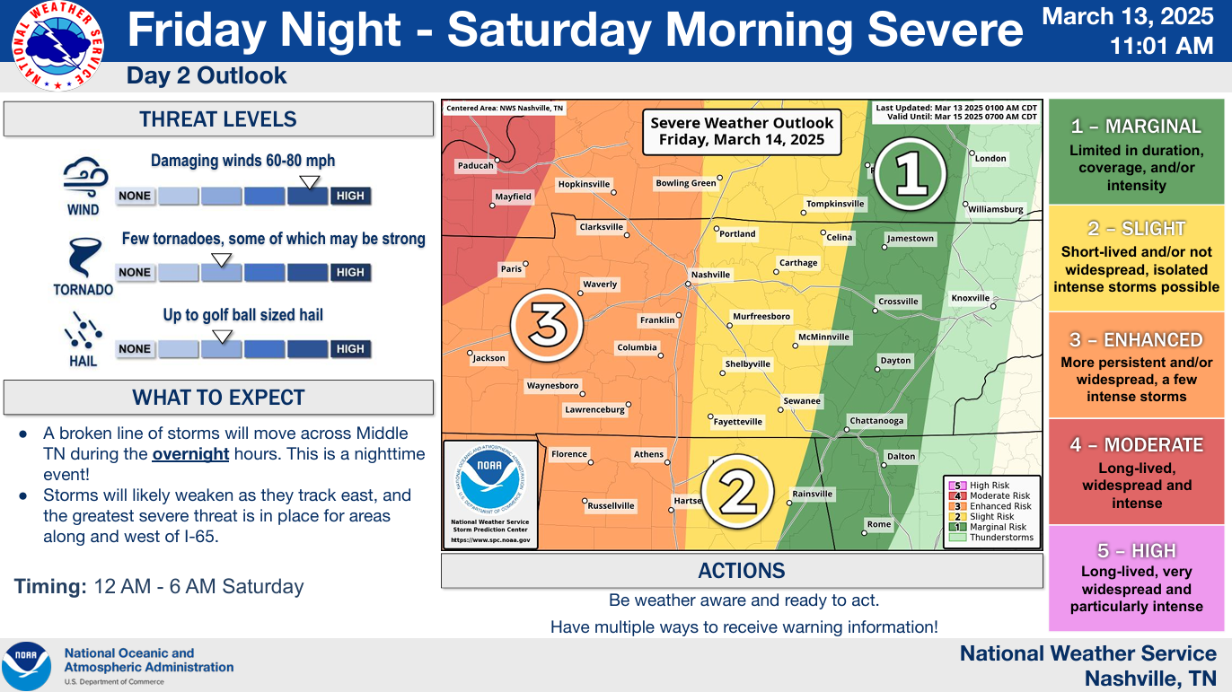
We’re looking at two potential rounds of severe weather, while both are conditional, both rounds bear watching.
From now until Saturday night, it will be important to be weather aware and stay connected for updates/changes to the forecast.

We’re looking at two potential rounds of severe weather, while both are conditional, both rounds bear watching.
From now until Saturday night, it will be important to be weather aware and stay connected for updates/changes to the forecast.

Beautiful Spring-like day ongoing.
Similar temperatures expected Thursday but can’t rule out a shower or thunderstorm during the afternoon/evening. No severe weather expected – can’t totally rule out some heavy downpours or even some pea-sized hail with a thunderstorm or two. Some of us will stay totally dry.


Before we discuss our active weekend, it is absolutely beautiful outside. High temp at BNA today was 79° – twenty degrees above average. Not a cloud in the sky.
Wednesday will be a copy and paste of today. Highs in the mid to upper 70s. Another great day to be outside.

Before we get into this weekend, we do have a warm and mostly dry work week in front of us.
High temps will be well above average all week long, in the 70s until Sunday.
First rain chances this week will be on Thursday. Although rain chances have increased since yesterday, totals still look relatively low.

Really nice Spring-like work week lies ahead of us.
Highs quickly climbing into the mid 70s by Tuesday, staying close to that for the rest of the week.
Doesn’t look like we’ll have any record-breaking heat, but highs will be ~15° above average.

Sunset tonight: 5:48p
Sunset tomorrow: 6:49p

We’ll lose an hour of sleep tonight – don’t forget to set your clocks forward an hour!
We may see a few sprinkles Sunday morning, “highest” chances in southern WillCo., but chances are relatively low everywhere.

Few sprinkles possible throughout the evening, but most of us will probably stay dry. Maybe bring a rain jacket just in case; or don’t if you’re feeling dangerous.

Rest of the weekend will be dry besides a few sprinkles possible Sunday morning, NBD.

Friday will be the exception to “cool” with highs in the mid 60s. Not half bad.
A [mostly] dry cold front will sweep thru Friday night, letting in cooler temps for the rest of the weekend.
Spring-like temperatures return Monday and look to stay with us for most, if not all of next week.

Our Wind Advisory will expire at 6p tonight, when the winds finally chillax. Until then, gusts up to 35 mph will have the cool day feel even cooler.
If you hear anything about accumulating snow – that only applies to the Cumberland Plateau. Can’t totally rule out seeing a few sprinkles, or even a few flurries this evening, but no accumulation is expected here.

A Wind Advisory is now in effect until 6p Wednesday. Sustained winds in the 20-30 mph range are expected, with gusts up to 50 mph not out of the question.
With the winds coming out of the S/SE, travel (especially for high-profile vehicles) may be a little tricky on W-E oriented roads such as 40 and 840.
You must be logged in to post a comment.