
We’re looking at two potential rounds of severe weather, while both are conditional, both rounds bear watching.
From now until Saturday night, it will be important to be weather aware and stay connected for updates/changes to the forecast.
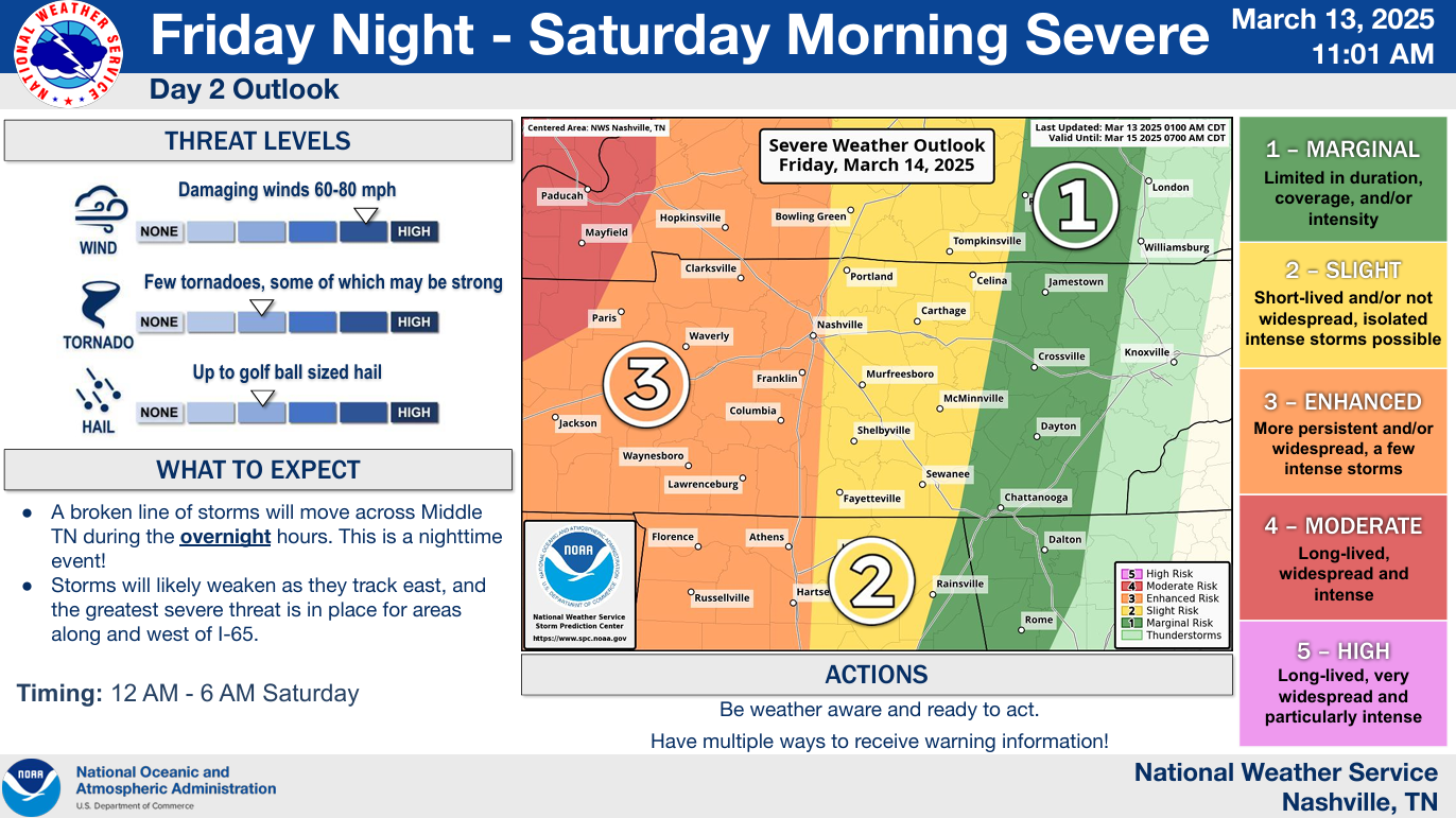
Round One: Late Friday Night – Early Saturday Morning

All modes of severe weather will be possible, with damaging straight-line winds being the main threat.
The Storm Prediction Center has outlooked with the following probabilities within 25 miles of any given location:
- 15% chance of damaging straight-line winds (58+ mph)
- 10% chance of a tornado (some may be strong, EF2+) along and west of 65, those to the east of 65 have a 5% chance – try not to get too caught up on exactly where the lines are drawn, storms don’t care about those
- 15% chance of hail (1″+ in diameter)
Timing:
Timeframe for storms looks to be anywhere from midnight to 5a Saturday, with the most likely time being 2a – 4a.

Uncertainties:
The big question will be whether or not there is enough forcing for storms to form. The ingredients for severe storms will be present, but there is uncertainty on whether or not storms will be able to break the “cap” (aka warm, stable layer of air aloft).
NWS Nashville thinks of this as a “boom” or “bust” scenario. If storms are able to form, they will be capable of producing all modes of severe weather. If storms don’t form, hooray, but we still have to watch out for Round 2.
Models:
Two of the higher resolution models we look at – the HRRR and the NAM3k – are both hesitant on storms making it here.
HRRR model (shown below) thinks some storms are able to form in W TN but weaken on their way here. This is the reason that areas W of I-65 have a higher severe threat than those E of 65.

This is something we will be watching closely. This is just one run of one model and things can change.
With this being a nighttime threat, you need to have a way to wake up if a warning is issued for you. Do not rely on sirens to wake you up. Here is a handy and helpful checklist to go thru.

A wake-me-up app such as StormWatch+ is also beneficial.
Round Two: Saturday Afternoon and Evening
Another conditional severe weather threat will exist Saturday afternoon/evening and certainly is worth watching.

The Storm Prediction Center has both of our counties (Davidson and Williamson) with a 30% chance of severe weather within 25 miles, with a ≥10% probability of significant severe weather.
Specific probabilities for individual hazards will be available tomorrow.
Uncertainties:
There are more uncertainties with this round. The severity of our storms will all depend on how far north the warm front will be and how much the atmosphere can destabilize. If we are north of the warm front = good news, storms are far less likely to be severe – if we are south of the warm front = ingredients will likely be present to produce severe weather, with all hazards possible. Another thing to watch will be if we see any morning showers, which would help prevent the atmosphere from destabilizing.
Unfortunately, this is not something that can be realized until the day of. Model data will continue to come in and confidence will continue to increase.
Timing:
Still some uncertainty on exact timing due to questions on how quickly morning storms move out of the area, if they do at all. Generally speaking, Saturday afternoon and evening will be the main timeframe for severe weather.
Preparing:
Both rounds of potential severe weather are well-worth watching. Stay connected for updates.
Know your severe weather plan – know where to go if a warning is issued for you! Here is a good link on refreshers for that + more: What To Do: Tornado Watch vs. Warning | Nashville Severe Weather
Details can and will likely change leading up to both Round 1 and Round 2. Stay informed and prepared! We’ll be posting updates as needed, with new blogs as well.
Traveling and/or looking for other folks to follow?
Additional Deets:
- Friday during the day will be dry and borderline hot, highs in the low 80s.
- Rainfall totals 2-3″ – minor street flooding possible but no widespread issues expected
- Gusty winds outside thunderstorms possible Friday evening – Saturday
- We clear out Sunday, start of next week will be warm + dry
- Skies probably clear for Total Lunar Eclipse viewing tonight
Categories: Featured Blog