Category: Featured Blog

Some No Big Deal Weekend Rain, Then 🥶 Mornings This Week

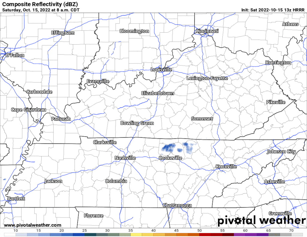
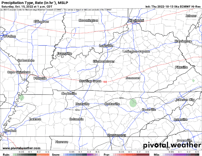
Probably won’t rain today. Not totes sure about that but I’m keeping my outdoor plans.

  • A few models think some of us will see a few light mid afternoon showers.
  • Most models think no rain.
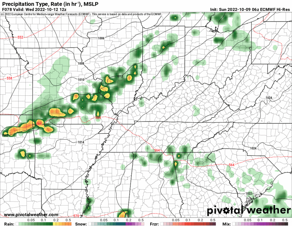
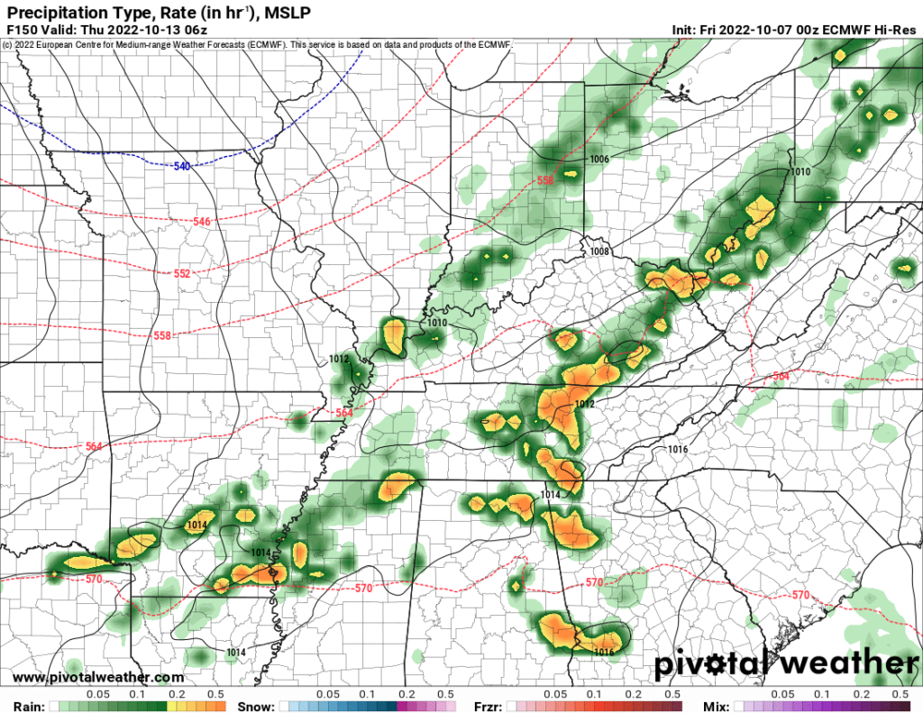
  • Latest HRRR run has it all just missing us 👇🏽

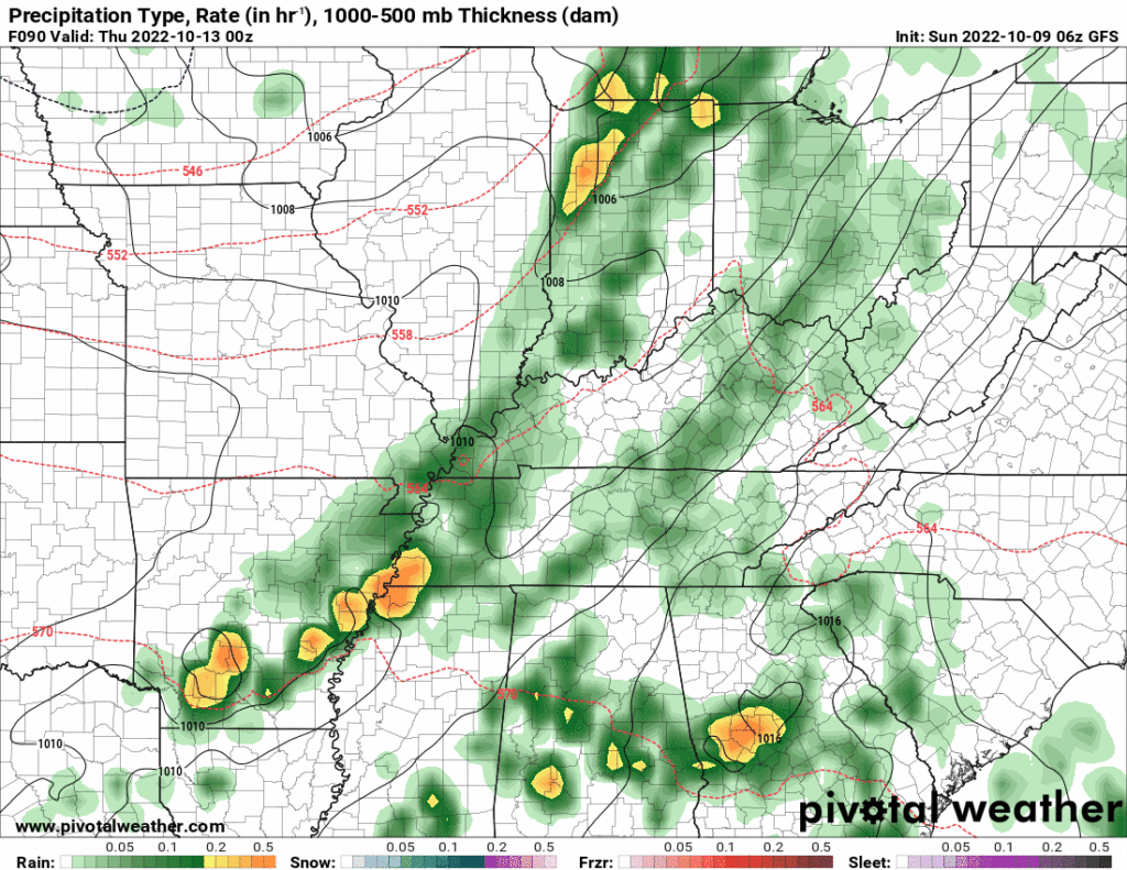
Rain expected Sunday.

  • Off and on.
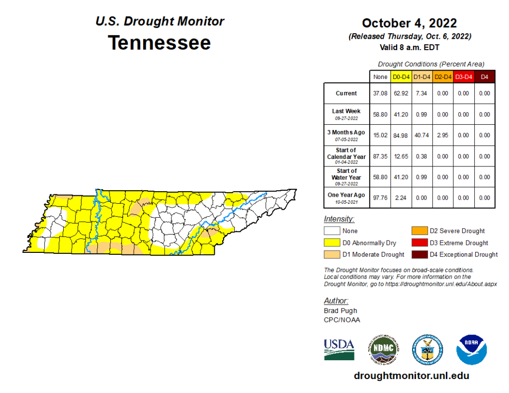
  • Average rainfall 0.1″ won’t dent our drought.
  • Some areas should get more than 0.1″, others less.
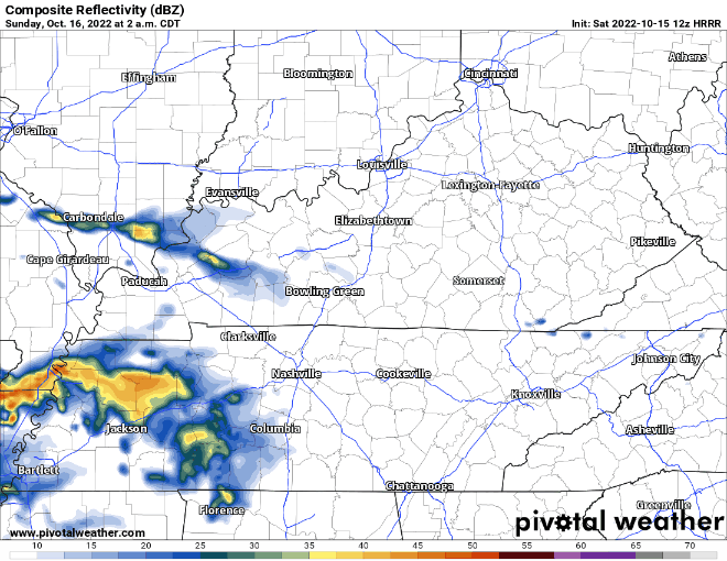
  • Few thunderstorms possible (more likely in the afternoon) but nothing severe.
  • Meh.

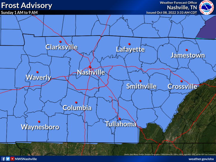
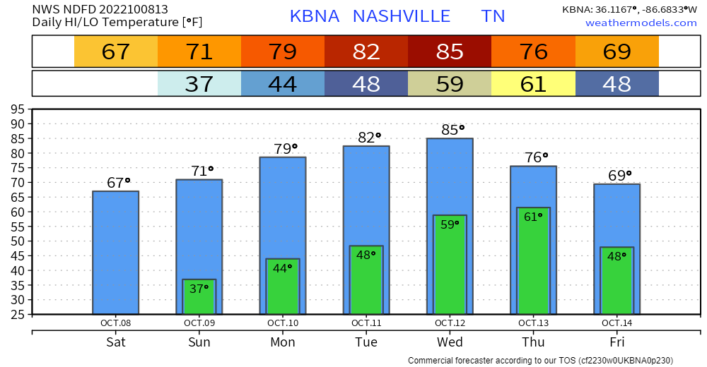
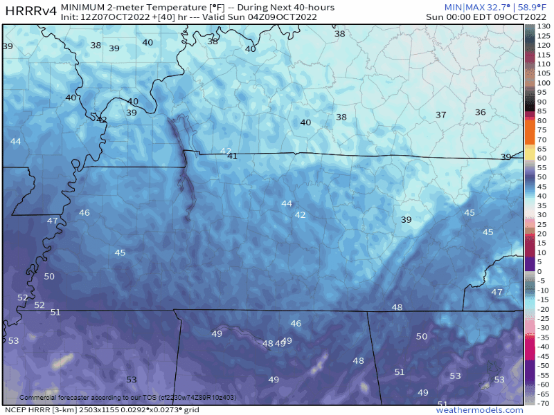
Frozen Tuesday-Wednesday-Thursday mornings incoming. Below chart shows lows around freezing. Most local backyards get a bit colder than official lows so expect below freezing temps 👇🏽: read more

Red Flag Warning: No Outdoor Burning Today

Fires may spread quickly out of control because

  • of winds 5-15 MPH, gusting to 25 MPH,
  • while the air is super dry with relative humidity approaching 20%, and
  • the ground remains super dry despite Weds night rain. We remain in drought.

The Warning expires at 7 PM.

Late Saturday into Sunday rain looks meh, off and on. Total under 0.20″ won’t dent drought.

🌩️ Few thunderstorms possible Saturday but the meh severe risk is in that dark green way west of us Saturday 👇🏽 read more

Today’s Afternoon/Evening Severe Weather Potential

Some light showers this morning – no worries with these.

🕜 General ETA for main line of storms is 4-7 PM –> HRRR model thinks 5-6 PM (This could very easily change, stay connected!)

🕜 NAM3k model thinks storms in front of the line arrive 6-7 PM, while the main line gets here around 10-11 PM. (Majority of models lean toward the HRRR solution, ETA of 4-7PM is more likely, but it is unwise to discount any model). read more

Liquid Cloud Discharge Potential Thursday

What’ll be a 31 day streak without 0.02″+ of rain might end Thursday morning.

🗣️ Wait, what was that about “might“?

  • It’s still a bit sus. Rain misses us in the last two Euro model runs, it goes east. (Makes sense, the good “moisture return” is east).
  • GFS disagrees, delivers streak-breaking rain 👇🏽

🗣️ Which one is right?

National Blend of Models thinks rain totaling 0.4″, so I guess go for that? I’m not betting on anything. We need the higher res models to get into range Tuesday to get a grip. read more

🆕 Forecast Change: Frost Advisory Overnight.

Frost Advisory tonight.

Cover or shelter beloved frost sensitive plants.

  • Advisory is technically for overnight, 1 AM to 9 AM. Coldest temps will last for a few hours around sunrise.
  • We do not think it’ll freeze but it’ll be close.
  • Models came in about three degrees colder overnight. BNA’s low went from 40° to 37°.
  • Your backyard is usually colder than BNA during fall and winter mornings.

Rain increasingly likely late Wednesday into Thursday.

  • GFS, Euro, and National Blend of Models show 0.6″ to 1.2″ rain total.
  • Most of this should fall Thursday.

🤞🏽 Thunderstorms – probably not severe – may accompany this rain. This’ll be a “high shear, low instability” event common here in the fall. read more

Upper 30°s Sunday Morning.

Dry cold front arrives today.

  • No big deal.
  • Upper 30°s for most backyards early Sunday morning.
  • Official BNA low 40° Sunday morning. BNA is among the warmer local spots during fall and winter mornings.
  • Frost unlikely, except on roofs.
HRRR model temps Sunday morning. Time stamps upper right.

Gradual warmup next week 📈.

Drought continues

  • Has not rained more than 0.02″ since September 11.
  • Next rain chance Wed-Thu next week. Not much, total of 0.3″ or so on average. This is a low confidence forecast.
Euro model for Weds night *unreliable at this range* but at least it’s nice to see rain on a model.

Quick References:

Weather changes constantly.
Follow @NashSevereWx on Twitter for any changes to this forecast.

Live coverage during tornado and severe thunderstorm warnings. read more

Deck Sealers Rejoice for “Moderate Drought”

We are all “abnormally dry.”

  • Even worse: most of Nashville is in a moderate drought.

You know how it happened:

  • Our last rain of more than a tenth of an inch was 0.44″ on September 11.
  • We average 3.80″ from Sept 1 to Oct 6. This year we’ve had 1.43″, almost all of which came the first two weeks of Sept.

Not even a chance of rain until maybe late Wednesday, Oct. 12. Low confidence in that.

It’s a great time to seal your driveway or stain your deck. read more