Thursday Storms: ETA + Hail? Damaging Winds & Tornadoes? Heavy Rain?

ETA

This afternoon our NWS updated its ETA. Storms are forecast to arrive between 8am and noon Thursday.

Hail?

Probably not much, if any. Our NWS:

WHILE THE FRONTAL SYSTEM TRAVERSES WESTERN TN AND APPROACHES MIDDLE TN ...SREF SEVERE PARAMETERS...CONVECTIVE AVAILABLE POTENTIAL ENERGY MORE THAN ANYTHING...PLUMMETS WITHOUT DAYTIME HEATING. THIS SEEMS TO BE A SHARED OPINION ACROSS THE MODELS. THIS WOULD CALM THE FEARS OF MANY IN THE WAY OF HAIL. read more

Thursday’s Squall Line ETA & “Will There Be Tornadoes?”

Storm Prediction Center (SPC)

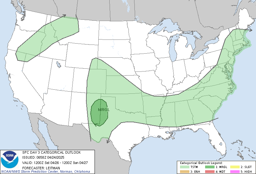
The SPC has included us inside their “SLIGHT” risk category for severe weather Thursday. The outlook map below begins at 7am Thursday. Given the fact we’re on the west edge of the outlook area, we can conclude the SPC thinks the squall line will arrive Thursday morning after 7am.

National Weather Service (NWS)

Our National Weather Service office agrees. They think our ETA is Thursday morning:

IMPORTANT DIFFERENCES REMAIN BETWEEN MODELS CONCERNING CONVECTIVE TIMING WITH THE GFS MODEL REMAINING A CONSISTENT FAST OUTLIER. WE ARE TRENDING TOWARD THE SLOWER NAM AND EUROPEAN MODELS, WHICH WILL FOCUS STORM CHANCES IN THE LATE WED NIGHT TIME FRAME WEST...THURS MORNING I-65 CORRIDOR...THEN LATER IN THE AFTERNOON ON THE PLATEAU. read more

There Will Be (Severe?) Storms Thursday. We Don’t Know What Time.

Discussing Thursday’s severe weather this afternoon, our NWS said:

TIMING REMAINS QUITE UNCERTAIN FOR WHEN PRECIP ARRIVES ... LATE WEDNESDAY NIGHT OR THURSDAY...AND HAVE GONE WITH A BLEND OF THE TWO MODELS FOR NOW IN COORDINATION WITH SURROUNDING NWS FORECAST OFFICES. DESPITE LOW CONFIDENCE IN TIMING...THERE IS HIGH CONFIDENCE IN WIDESPREAD SHOWERS AND STORMS OCCURRING... read more

Squall Line Expected Sometime Thursday. Damaging Winds Likely. Few Tornadoes Possible

Just got off the weekly NWS conference call with media and emergency management. Here’s the scoop:

1.   Expect a squall line of storms to arrive Thursday. Damaging “straight line” winds are the most likely threat. A few tornadoes are also possible. read more

NWS: We May Have Severe Weather (A Few Tornadoes?) Thursday

During the afternoon discussion about Thursday’s storm potential, our NWS said:

THE SETUP LOOKS LIKE A QLCS EVENT FOR MID TN WITH THE POTENTIAL FOR A FEW TORNADOES. THERE ARE STILL A LOT OF UNCERTAINTIES REGARDING TIMING AND DETAILS...SO PLEASE MONITOR UPDATED FORECASTS AND OUR HAZARDOUS WEATHER OUTLOOK CLOSELY OVER THE NEXT FEW DAYS. read more

Tomorrow’s Small Rain Chance. Storms Thursday?

Sunday 51/73

Clouds will file in Sunday afternoon. Light rain is possible. Here’s what the models think:

European (ECMWF):

European Model as of Sunday at 1pm. This is very, very light rain.

American (GFS):

American (GFS) model, also at 1pm Sunday. The 4pm run takes the precip N of Davidson & Williamson Counties

Any rain is forecast to be light. It should not ruin any outdoor activities. read more

Beautiful Saturday! Sunday Almost as Great. Mid-Week Storm Update.

Tomorrow 42/73

It will be awesome!

Sunday 49/73

The NWS includes a “slight chance of showers.”

The GFS and NAM weather models think we will be dry here, but it will rain in southern Kentucky. If the models are wrong by 50-75 miles, we will get wet.

The European model says we might see a few hit or miss showers Sunday afternoon.

It probably won’t rain. More on this tomorrow night.

Mid-Week Storm Chances

Anyone who says they know what will happen is lying.

When weather models are consistent run-to-run, and are then consistent with each other, forecasters can have confidence about what kind of storms to expect, and when we can expect them. With this week’s storm system, the models aren’t consistent.

The European model thinks storms will arrive Thursday morning. Here it is Thursday at 7am:

Euro Thu 7am

The GFS (American) model has been wildly inconsistent with (1) it’s prior runs and (2) the European model. The latest GFS model run delivers storms Wednesday afternoon, almost a day before the European model:

As usual, our NWS expresses the forecast quandary best (ECMWF is the European model; “Ensembles” are multiple runs of the same model). Our NWS likes the European solution better because it has been consistent with its prior runs:

FORECAST PROBLEMS ABOUND MIDWEEK...WITH THE LATEST GFS AND ECMWF SHOWING VERY DIFFERENT TIMING WITH THE NEXT WEATHER SYSTEM. THE LATEST GFS BRINGS A COLD FRONT THROUGH MID TN TUESDAY NIGHT...A FULL 24 HOURS EARLIER THAN MOST PREVIOUS RUNS AND MORE THAN 36 HOURS AHEAD OF THE ECMWF. PER WPC GUIDANCE AND CONTINUITY WITH PREVIOUS FORECASTS...WE WILL LEAN TOWARD THE ECMWF ENSEMBLES AND MAINTAIN EXPECTED FRONTAL PASSAGE THURSDAY MORNING. EARLIER WE UPDATED THE HAZARDOUS WEATHER OUTLOOK TO MENTION THE POTENTIAL FOR STRONG STORMS...AND THE VERY UNCERTAIN POTENTIAL FOR SEVERE WX.THE POTENTIAL STILL EXISTS...BUT THERE ARE STILL TOO MANY UNCERTAINTIES TO OFFER ANY ADDITIONAL DETAILS AT THIS TIME. read more

Rain Leaving. Beautiful Spring Weekend. Storms Next Week?

The chilly rain is leaving tonight. We’ll have a dry and chilly Friday morning, then quickly warm into the mid 60s. Expect a beautiful Spring weekend, with high temps in the mid 70s. read more

Backpedalling (a Bit) on Tomorrow’s Rain

Yesterday’s forecast called for about 1.25″ of rain tomorrow. Time to backpedal!  Looks like the rainmaker is going to move further south and way east of us. We still think it’ll rain, just not that much. read more

How Much Rain on Thursday? (Enough to cancel soccer practice)

I coach my daughter’s under-8 soccer team. We practice every Thursday at 5pm. I’ve already canceled practice for this Thursday due to rain (well, that, and we’ve already played a night game this week). read more