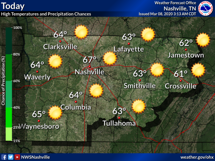
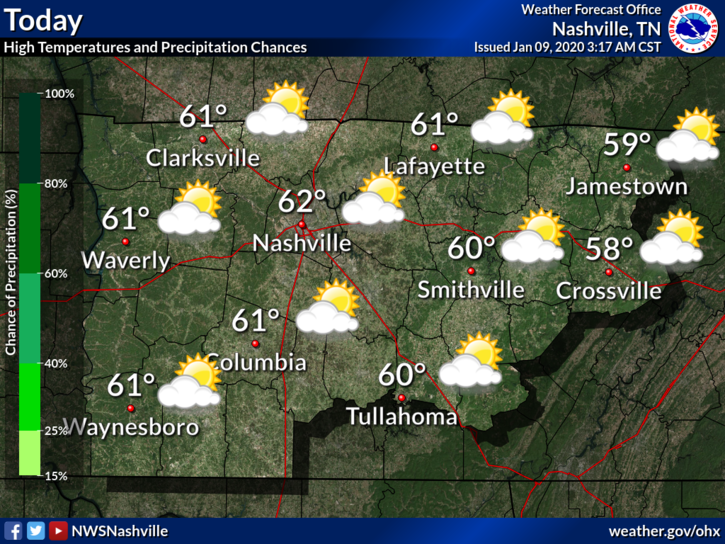
Rain This Week

Comfortable Sunday

Beautiful weather ahead for today:

Keep in mind that as today makes a great day for clean-up efforts, crews will be out working. Volunteers are greatly appreciated, but please do not park on tornado-impacted streets as it will already be very busy in these areas. Commercial trucks and clean-up crews need room to work, so be please mindful of them. If you park in their way, they can’t work.

Rain Returns Monday, Off and On Showers Last Through the Week

Monday starts off dry, but rain moves in during the afternoon/evening, kicking off a wet week.

The NAM3 model shows scattered showers moving in tomorrow around 8pm:

The GFS model also shows showers moving in tomorrow evening, with a break Wednesday morning, and then heavier rain before we have another break on Friday:

NWS-Nashville sums it up here:

A very unsettled weather pattern for the week due to the front that comes through tomorrow night and stall/waffles across the Southeast US for the week… Extended models are in OK agreement but timing of the more moderate rainfall differs at times. The good news is rain amounts for the week will be somewhere between 1.5 and 3 inches. As we have been mentioning there could some afternoon thunderstorms but no severe weather is expected.

NWS-Nashville AM-Discussion 03/08/20

Note that there are no flooding or severe weather concerns. Rain will not be consistent as showers come in waves. Some rumbles of thunder are possible, but no worries about severe weather.

Peek into the Weekend

The chance of rain carries over into the weekend, unfortunately. Right now, extended models show the majority of rain Saturday, with most of it clearing out Sunday. This is still far out, model data at this range is poor, so stay tuned for updates.

Warm Temps

It may be a wet week, but daily high temps will be on the milder side:

Few More Flurry Chances, Nice Weekend, Heavy Rain Next Week (Super Soggy Tuesday)

Sunny Thurs-day . . . Tonight, Flurries?

Dry and sunny with a high temperature of 45°. A little chilly, but at least no rain.

Overnight Rain/Flurries

Another “clipper system” will streak by after midnight Thursday into early Friday morning. Delivering a quick blast of rain and/or snow flurries. It’s not much.

HRRR model from midnight tonight to 9 AM Friday.

Temps aloft might support snow but surface temps won’t let it stick. Better chance of a dusting is well east and southeast of us, at higher elevations.

Rain will be off and on for the day Friday, but we won’t see much. If we see some flurries, there will be little/probably-no snow accumulation here around Nashville.

Here’s a look at the NAM3 model from Thursday night through overnight Friday:

Rain should clear out after this system departs late Friday night. No meaningful rainout worries for weekend activities.

Clear and Dry Weekend

The weather this weekend? Beautiful.

Skies will be sunny. High temps Saturday will reach 50°, then jump to 63° Sunday.

Live look at me this weekend trying to hold onto this nice weather:

Saturday is Severe Weather Awareness Day at Trevecca and our inaugural MLS game against Atlanta. No weather interruptions for either. Southwest winds so temps in the 40s won’t feel that bad.

Heavy Rain Next Week

Monday rain could resume as early as before sunrise. Rain chances increase during the day. Rain is likely Monday night. Super Tuesday will be wet, potentially very wet, as a heavy rain system sets up.

Here’s what NWS-Nashville currently says:

Thus, the feature wont move much and ample amounts of rainfall will return as sfc energy repeatedly moves northeastward along the boundary. 7 day qpf amounts suggest 2-4 inches for the Monday through Wednesday period. If this happens, it will reaggravate the rivers, and we will have flood problems to contend with once again. So stay tuned.

NWS-Nashville AM Discussion, 02/27/20

This is something we will keep an eye on. The 7 day total rainfall map is gross:

The system will bring a severe weather risk south and southwest of us. The Storm Prediction Center has already outlooked large sections of Texas, Arkansas, Mississippi, and Louisiana for severe weather. Memphis is included:

The center of this storm system is expected to pass too close to us to spark local severe weather, but at this range, draw no conclusions. For now it looks like another heavy rain event with river flooding potential.

Showers Later Today, Rain Monday, Possible Flurries Wednesday

Showers Possible Later Sunday, Rainy Monday

High temps today (Sunday) will reach 56°.

Light showers are possible as early as this afternoon. Rain is more likely tonight. Not everyone will see rain tonight (it’ll be scattered), but the greatest chance of seeing some sprinkles is this evening.

High temps Monday will reach 55°. It will rain off and on most of the day.

Here’s the NAM3 model from late Sunday afternoon through overnight Tuesday:

Up to 1 inch of rain can be expected between now and Monday. More likely 0.5” to 0.75”.

Dry Tuesday

Tuesday should be dry and skies should clear some. Don’t get your hopes up though, because the rain isn’t finished yet this week.

High temps on Tuesday? A comfortable 60°.

Chance of Showers Returns Wednesday, Possible Flurries

NWS-Nashville sums up Wednesday nicely:

Expect little precip, gusty west winds, and falling temperatures during the day on Wednesday. Precip will start out as rain in the morning, but should become a mix of rain and snow before transitioning to all snow by that evening. Any accumulations are still expected to be very light. The Plateau has the best chance of seeing totals up to an inch.

NWS-Nashville AM-Discussion, 02/23/20

The GFS model says no to snow in Nashville or Will Co, but here’s a peek at the EURO model:

Disclaimer: Take any snow/flurry chances at this range with a grain of salt. Temps will drop to a low of 29° by early Thursday morning, so temps could support some flurries. However, surface temps will likely be too warm to support much/any accumulation, so no need to run and grab bread and milk. Of course, this is something we will watch and keep you updated on.

Skies should clear Thursday and weather will be dry.

Light Showers/Possible Flurries Friday and Saturday

Chances of light showers and a few potential flurries are still on the table for this weekend, but chances are low and it is still too far out to really know much more than that.

Skies should clear and temps should begin to warm again by Sunday.

Overview of temps this week:

Rain Today, More Monday Night thru Tuesday Night, Colder Thurs, Drier Next Weekend

Light Showers on Sunday

Showers are currently moving into the area from the west. Nothing heavy, but enough to probably want an umbrella or some sort of buffer.

The chance of rain is low after that, but not nonexistent. Here’s the HRRR model through tonight:

If any other showers race by today, they will be scattered and brief.

High temperatures will reach 54°.

Calm Monday

High temp will reach 62° with mostly cloudy skies. Overall, a comfortable day.

Next Rain Chances Begin Monday Night

The GFS model shows rain beginning overnight Monday, clearing out by Tuesday night.

The EURO model shows rain moving in closer to Tuesday morning, clearing out by Tuesday night.

Overall, expect rain overnight Monday into Tuesday night. It’ll be off and on.

Widespread rain chances will then move into the entire area on Tuesday ahead of a cold front. Models continue to suggest only a few tenths of an inch of rain with this system due to its much more progressive nature and lack of strong deep forcing that the previous few systems had.

NWS-Nashville AM-Discussion, 02/16/20

A few stray showers could still linger behind early Wednesday morning, but the main system should be out of the area by then.

SEVERE WEATHER?

So far, no concerns. Not enough shear/instability expected.

Then Cooler Air Moves in, Calmer Weather Beginning Thursday

A look at temperatures this week:

Notice the drop in temperatures after the passage of the cold front mid-week. Take note that Saturday morning will also be very cold if you have plans early on.

Good news? Thanks to high pressure, skies should be clear Friday into this weekend.

Colder! Next Rain Event Early Next Week

Rain Clears out Thursday

Besides some potential drizzle, the rain finally clears out today. If this is your reaction reading this, we understand.

Clouds linger with temperatures stuck in the low 40°s.

Cool northwesterly winds will be 10-15 MPH with gusts as high as 20 MPH. This will put wind chills below freezing this afternoon.

Cold Friday, then Temps Bounce Back

Very cold Friday morning. Low near 20°, wind chill near 10°. Barely above freezing Friday afternoon.

We warm up Saturday afternoon. The weather will continue to stay dry until a chance of showers returns Sunday.

Any showers on Sunday will be light and isolated.

Next Chance of Rain: Monday Night/Tuesday

Another cold front sweeps the region early next week, bringing more rain to the area.

Here’s what NWS-Nashville currently says:

Heavier rain will occur Monday night through Tuesday night, with even isolated thunder Tuesday as some instability showing up with the front. Pcpn may even mix with snow early in the morning Wednesday. Light pcpn may evening linger Wednesday night as well, possibly ending as a another light mix overnight. No impacts are expected at this time from winter wx. Dry conditions return Thursday.

NWS-Nashville AM Discussion, 02/13/20

Right now, the GFS and EURO models keep the “s” word outside of Nashville. Looking ahead, temperatures also won’t drop below freezing. Of course, this is something we will keep an eye on, but wintry weather isn’t looking likely at the moment.

Enjoy the break in rain and stay warm!

Rain Incoming, Dry Weekend, Warming Trend

Rain Thursday into Friday Morning

The HRRR model shows rain moving in this afternoon (around 2pm):

The NAM3 model says rain closer to noon:

Regardless, plan for rain around lunchtime and after.

Showers will be off and on tonight through Friday, and sorry snow lovers, no snow. Those in the Plateau may see some light flurries Friday night/Saturday morning, but there will be no impacts.

High temperatures will hang at 46° today and Friday. It’ll be breezy though so be ready for cold rain with upper 30°s wind chills.

Rain should end Friday morning, with maybe a few drizzlers Friday afternoon.

Dry Weekend, Warming through Next Week

Dry weekend, lingering clouds.

High temps drop on Saturday, then we begin a warming trend:

Next Rain Chance Mid-Next-Week

Rain chances return mid-week, but there is currently some uncertainty with the models. Here’s what NWS-Nashville says right now:

Monday and Tuesday will be dry with highs in the upper 40s and 50s. GFS and Euro do not agree what to do with the next trough around midweek. Euro wants to develop an upper low over the southern plains that will slide toward the area on Wednesday. GFS keeps the upper energy disorganized and unphased. Each solution, however, brings showers back in the forecast by Wednesday. Another trough will be on the heels of the Wednesday disturbance with more showers on Thursday.

NWS-Nashville AM Discussion, 01/23/2020

The Cold is Here; Gradual Warm-Up this Week; Rain Chance Returns Fri

Dry and Cold Sunday

At 10:00 AM it was 34°, the wind chill was making it feel like the mid-20°s.

High temperatures today will reach 36°, but northwest winds will keep bringing in cold air, making it feel like the 20°s all day.

Overnight lows temps much colder, low 18°. The wind chill will be single digits just before sunrise Monday morning.

Gradual Warm-Up

Cold temperatures will linger some – especially in the morning – but we will see a gradual warm-up this week:

Wind chills will also be in the 20°s on Monday, so keep the heavy coat around. We won’t have to worry as much about this beginning Tuesday.

Note that the beginning and middle of the week will be dry.

Next Rain Chance Friday

Models are not completely in agreement just yet, but all agree on the strength of the upper low and bringing rain chances into the region late Thursday night through Saturday morning. Right now, have likely pops in during the day Friday when best model agreement occurs.

NWS-Nashville AM Discussion, 01/19/2020

Here’s a look at the models, which generally agree on rain Friday:

The GFS Model
The EURO Model

ANY FLURRIES?

Now here is where the models differ and want to do their own thing.

No winter precip with this event, but the 00Z ECMWF has gone a bit colder and brings in some sub 0C 850 mb temps Saturday morning and some post frontal moisture. The GFS keeps the same story we are used to in the mid state with moisture out of the area by the time temps cool enough for any wintry precip.

NWS-Nashville AM Discussion, 01/19/2020

In other words, the EURO wants some flurries on Saturday and the GFS doesn’t. It all depends on if there is any lingering moisture, and how quickly the cold air catches up to it, but it doesn’t look likely that it will happen. Plus, temperatures will be around 50° at the surface. Too warm to sustain flurries.

Saturday Rain Maker, Much Colder Temps Move in Sunday

Dry Thursday and Friday

High temperatures today (Thursday) will reach 49°. Winds will be 10-15 MPH with gusts as high as 20 MPH.

Friday will reach 48°. Showers in the afternoon/evening are possible, but we aren’t really counting on them. If we see any, they will be light and brief.

Another Rain Maker Saturday

A cold front this weekend will bring another round of rain to the area, followed by cold temperatures.

TIMING

The GFS model shows showers Saturday morning with the main line passing through in the afternoon:

The EURO model agrees:

Rain should clear out by Saturday night.

WHAT TO EXPECT

Just rain! Due to little to no instability, we don’t expect any thunderstorms.

It’ll also be quite windy Saturday morning before the front passes:

The low level jet will ramp up Friday night and Saturday morning and by 12z Saturday 850mb winds will be 50-70 kts and 925 mb winds will be 40-50 kts. This will translate to a very breezy Saturday morning. Wind gusts around 40 mph ahead of the front does not seem like a stretch.

NWS-Nasvhille AM Discussion, 01/16/2020

Here Comes the Cold

After that, we will feel another round of chilly winter temperatures beginning Sunday.

Dry Sunday and Monday; Next Rain Chances begin Monday Night, Off & On thru the Weekend

Sunday and Monday: Quiet

High temperatures today (Sunday) will reach 54° with mostly cloudy skies.

Monday looks the same but with a high of 64°.

This is a nice break after the very windy and rainy weather we had yesterday.

Rain This Week

… and there is no end in sight (just kidding, but it may feel like it). A few active weather patterns look to bring the chance of rain to the area all week.

TIMING

Below is the GFS model Monday night through Saturday night. It shows scattered showers Tuesday and Wednesday, a break Thursday (though light showers will still be possible), with more rain Friday and Saturday.

The EURO model agrees, except it wants rain Thursday (through the afternoon) and a drier Friday

Rain should clear out by Saturday night (as of right now).

If you want the technical stuff, here is a chunk from NWS-Nashville:

This unstable weather pattern will also promote development of scattered to numerous showers and isolated to scattered thunderstorms across mid state region especially Tuesday into Wednesday. Still looks like weather pattern across mid state region will significantly change by Wednesday night as a strong cold frontal passage north to south occurs… Upper level flow will actually develop weak ridging characteristics across mid state region Thursday afternoon into the first half of Friday. Somewhat of an unorganized surface pattern will come into play too, with a frontal boundary positioned to our north, so isolated to scattered showers will be possible… A more organized weather system looks to move into mid state region by late Friday night into Saturday bringing scattered to numerous showers once again to mid state region.

NWS-Nashville AM Discussion, 01/12/2020

WHAT TO EXPECT

Rain and maybe some thunderstorms. So far we don’t expect anything severe.

Here is an overview of the week through Thursday:

Notice the unseasonably warm temperatures and then the cool down on Thursday. By Friday, highs will increase to around 60°.

Rain Begins Friday, Very Windy 48 Hours Ahead; Heaviest Rain/Storms (Some Possibly Severe) Saturday

Warm & Windy (62°) Thursday

15 to 20 MPH winds with gusts as high as 30 MPH. Secure hats and lightweight aunts.

It’ll be windy Friday and especially Saturday.

Rain Begins Friday, Storms (Strong/Severe Possible) Saturday

WHAT THE MODELS SAY

The GFS model shows light, scattered showers late Friday, with the heaviest rain and storms sweeping through Saturday afternoon:

The EURO model says Friday afternoon rain, with heavier stuff Saturday afternoon/evening:

The NAM3 model says scattered showers beginning Friday afternoon, heavy rain Saturday evening:

Expect showers Friday. Then, it looks like heaviest rain Saturday afternoon/evening. Of course there could still be some adjustments given this is 1-2 days out.

Rain should move out Saturday night (possibly before) and leave us with a clear and dry Sunday.

EXPECTED RAINFALL, MINOR FLOODING THREAT

Minor flooding is possible in some areas due to heavy rainfall rates, but we don’t expect widespread effects because rain will move through quickly. Earlier this week models showed twice as much, some more, rain than this. This downward trend is a good sign.

SEVERE RISKS & THREATS

Before the main storm event Saturday afternoon, winds will be exceptionally strong. Winds will be blowing from the south at least 30 MPH, maybe 40 MPH, possibly as high as 50 MPH. Again this is before the main storms show up.

When the storm line arrives Saturday, ETA 11 AM to 2 PM, severe weather is possible.

This ETA may need revision. It may arrive sooner or later than that.

The line will speed west to east, so it’ll be in and out quickly.

The main threat is damaging winds. These winds may be strong enough to knock down trees, power lines. This is a powerful system.

A secondary, less likely, threat is a few spin up tornadoes. NWS-Nashville held a weather briefing this morning. The lead forecaster mentioned the tornado threat may change, so “don’t rule out the possibility of a tornado.” This forecast will need to be updated, especially as it relates to tornado potential. The system is very strong; right now models think tornadomaking instability will be lacking, but if that changes, we may have to deal with tornadoes. For now, the concern level is low.

Deep layer shear really increasing Fri night and goes pretty high-end on Sat. Models however continue to show limited instability.  ML/MUCAPE is higher on latest GFS than previous runs, EURO slightly higher as well but both keep under 300J. Even so, parameters easily sufficient for isolated strong/severe storms on Sat. If we get a bump in instability, which is very possible, we could see a decent tornado threat.

NWS-Nashville AM Discussion, 01/09/2020

NWS-Nashville hazard graphic:

Translation: ingredients are there to potentially see some severe weather. CAPE (storm fuel) is still on the lower end, but an increase in CAPE would be cause for concern. At this moment, we aren’t too concerned, but it is something to watch.

After the rain . . .

Dry and cooler Sunday, with more rain possible next week. Some models show cold air next Saturday the 18th (a few show snow), but the more reliable models keep the colder air bottled up. It doesn’t get here. No wintry weather is expected in the foreseeable future.