Snow this morning, followed by a blustery day

Good morning Nashville! Alex Forbes here this morning and I am thrilled to say I will be joining NashSevereWx on a regular basis! Now to today’s forecast…

Today

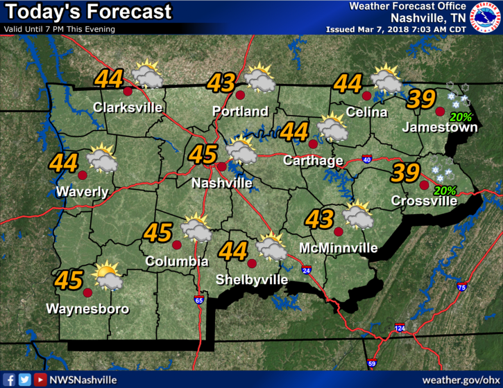
Did you catch a snow shower this morning? We didn’t get much in Williamson and Davidson Counties, a dusting at best, because our temperatures stayed above freezing. However the further north you go, and out on the plateau, you will find higher snow amounts and a few minor travel impacts. The snow is done, giving way to a partly cloudy, and blustery, 48° day. Winds could reach 15-20 mph. read more

Cool Today, Rain Returns for the Weekend, but SUN is in Sight!

Good morning! This is Alex Forbes with NashSevereWx’s guest-forecast for the day.

 Today

Winter reminded us this morning that it is still around! We had low temperatures near freezing in the Nashville metro area and we are not going to rebound much through the day. Significant cloud cover will be present providing little movement in our temperatures, going for a high of 45º. read more

Warm, Breezy Tuesday; Mid-Week Cool Down into a Wet Weekend

Hello! This is guest-writer Marti Calhoun, here again with today’s update!

Flood Advisory

Due to the amount of rain received yesterday and overnight, a flood advisory for the Nashville area is still in effect until further notice. read more

Rain Jacket Needed Today, Below Average Temperatures Expected by Mid-Week

Hey there! I am Alex Forbes, NashSevereWx’s guest-writer for the day. I am currently a freshman at Mississippi State University and originally hail from the Metro Atlanta area. I’m excited to be around a couple days this week and hope you enjoy the posts. read more

Sunny Skies this Weekend, Rain Expected Monday

Hi everyone, my name is Caroline Sleeper and I am a freshman at Mississippi State University. I am a Professional Meteorology major with an emphasis in Broadcasting!

Sunshine this Weekend

The sun will be shining Saturday and highs are expected to be in the mid to upper 50s. The sunshine will hang around for Sunday, and the highs will be slightly warmer, climbing to the mid 60s. Lows are expected to drop to freezing, or even slightly below, Saturday night. We are seeing more seasonal conditions this weekend. Warmer temperatures in February appeared to jump start vegetation growth, so frost could be impactful. So if you’re ahead of most of us in spring planting, you might want to cover those plants Saturday night. read more

Sunny Skies and Cooler Temperatures

Hello everyone! My name is Marti Calhoun, and I am a Senior at Mississippi State University. I’m pursuing a degree in Professional Meteorology with a minor in Geographical Information Systems.

The dry air is here! read more

Rainfall Expected for Thursday, Drier Weather this Weekend

Hi everyone, my name is Caroline Sleeper and I am a freshman at Mississippi State University. I am a Professional Meteorology major with an emphasis in Broadcasting!

Flood Watch until Noon Thursday

read more

Umbrella Rage Leads to Sunny Days

Current Radar

Headlines:

Screen Shot 2016-02-24 at 7.24.56 AM

A few heavier rain pockets and even a few rumbles of thunder are occurring northwest of Davidson county. This activity should pull away to the north and east as a larger low pressure system traverses Tennessee and into the Ohio Valley. read more

A Messy Next 48 Hours

Current Radar

Well if you are one of those people who likes to see the weather change rapidly, you are in for an interesting next 24-48 hours.

To begin, the Flood Advisory for the Stones River (due to Percy Priest Dam release) remains in effect until 6 PM. read more

Unsettled days ahead plus a look at Wednesday night!

Current Radar

We know, everyone is dying to see if the snow chances are increasing or decreasing for Wednesday night. BUT FIRST we have a couple days of rain to get through!

Stitch Rain

Monday: Enjoy the dry spell read more