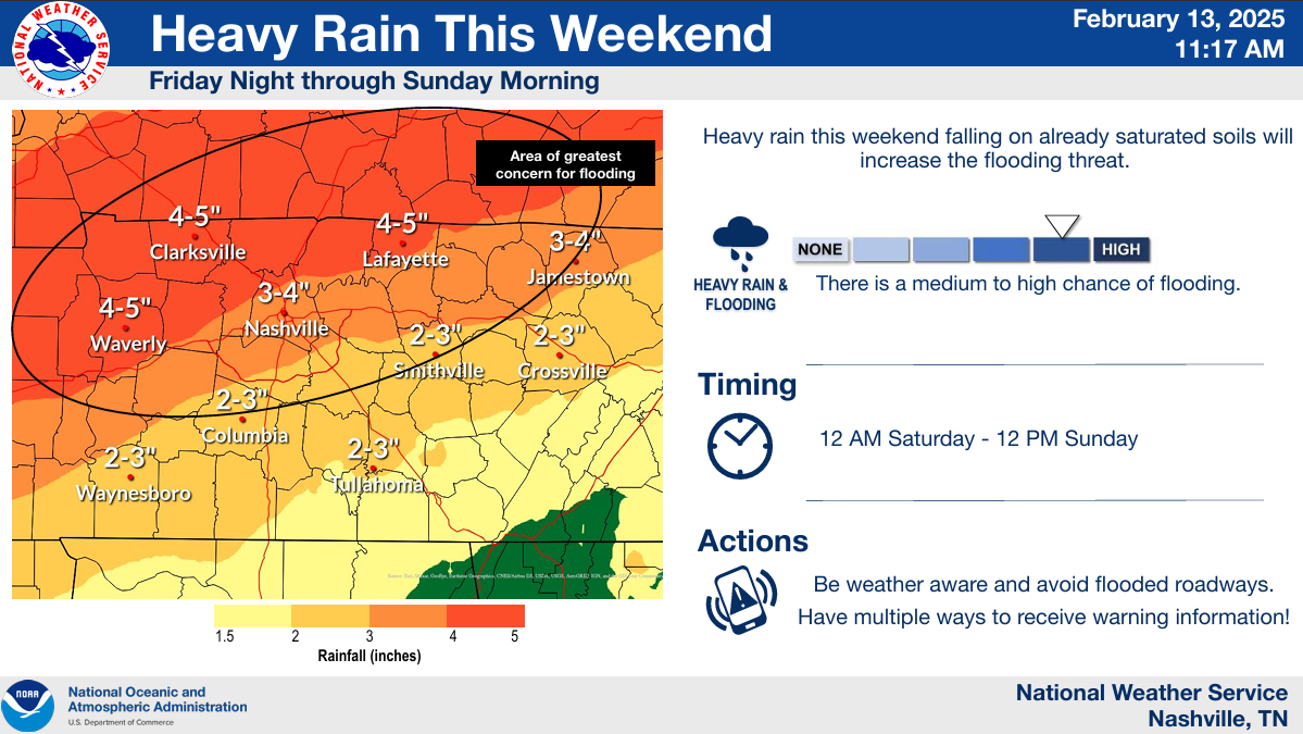
Author Archives

Elan

Watching the Flooding & Severe Storm Potential This Weekend

Headlines:

  • A Flood Watch will be in effect from 12a Saturday to 12p Sunday
  • “A significant rainfall event is expected to bring an additional 3 to 5 inches of rain to Middle Tennessee this weekend.” – NWS Nashville
  • There is a low chance of severe weather Saturday afternoon and evening
  • Confidence is very low for any winter weather potential mid next week

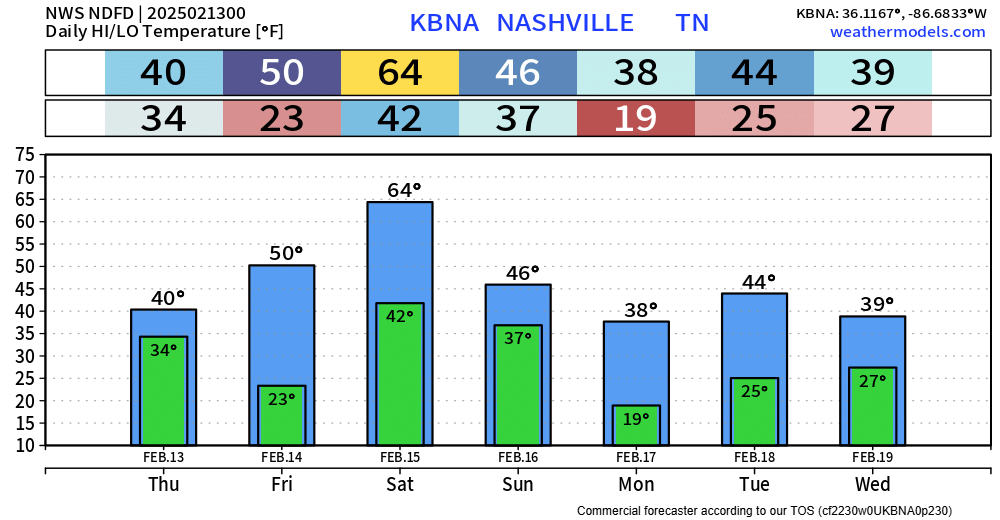
Before we jump into our very active weekend, the rest of today and Friday should be dry.

We’ll wake up to temps in the low to mid 20s Friday morning – the coldest we’ve dealt with in a while. A jacket will certainly be needed in the morning for the bus stop. read more

Rising Flood Threat This Weekend, Strong Storms Also Possible

Headlines:

  • 2-5″ of additional rain is expected Saturday morning thru Sunday morning
  • There is increasing confidence regarding the potential for flash flooding during this time
  • River/creek rises are also possible during this time
  • Strong to severe storms are also possible Saturday PM

Rain will come to a pause (for now) over the next couple of hours. Rainfall totals have thankfully been light today, the same unfortunately cannot be said about this weekend.

But first, we are lucky enough to get two dry days out of Thursday and Friday. read more

Flash Flooding, River/Creek Rises Possible This Weekend

Headlines:

  • Flash flood threat is increasing for Saturday and Sunday, 3-5″ of additional rain is possible
  • River/creek rises will be possible, especially this weekend as rainfall totals begin to add up
  • If you live in or near a designated flood plain or in a place that has flooded before, *heads up*. Between now and Saturday, make preparations in case water threatens your home.
  • Strong to severe storms are also possible on Saturday

Majority of us have received 1.5 – 2.5 inches of rain so far, with the rain ending over the next couple of hours.

So far, we have been able to avoid any flooding issues – besides some ponding on roads and some creeks rising a tad. read more

Multiple Rounds of Heavy Rain Throughout the Week, 4 – 6″ of Rain Possible

Headlines:

  • Two rounds of heavy rain will lead to potential flooding issues, rises in creeks/rivers
  • Rainfall totals thru Sunday will likely add up to 4 to 6″, locally higher amounts possible
  • No severe or winter weather concerns right now

Round One of Heavy Rain: Tonight – Wednesday Night

Rain will move in late tonight and stick around for the majority of the day Tuesday. We will probably get a break overnight Tuesday thru Wednesday morning, with more rain Wednesday PM. read more

Cooler Temps & Maybe a Lil Too Much Rain Next Week

Scattered showers possible thru the evening, rain gear handy for any plans tonight will be useful.

A few stray showers can’t be ruled out Saturday during the day, but most of the rain chances will hold off until the evening – when a cold front pushes thru the area. This will bring some rain and signal the end of our warmer weather (for now). No thunderstorms expected. read more

Low Chance of a Strong to Severe Storm Thru Thursday Morning

Rain/storms are expected to move into the area throughout the remainder of the day, with a low chance of being strong to severe.

The Storm Prediction Center has us outlooked with a 5% chance of damaging straight-line winds and/or hail within 25 miles. We are also outlooked with a 2% chance of a tornado within 25 miles. All relatively low chances, but not zero. read more