Dry High Pressure Monday & Tuesday
Expect a cool Monday morning. 63°.
We’re going to heat back up again. High 89° Monday, 90° Tuesday.
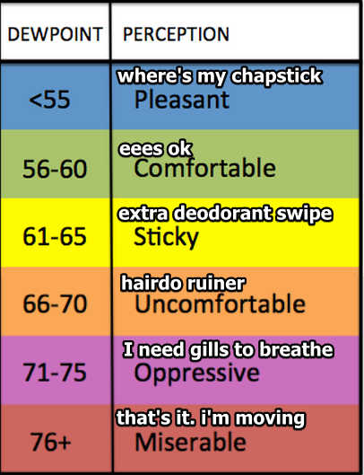
Humidity will rise every day this week.
Monday’s humidity will be sticky; Tuesday will be almost uncomfortable.

Expect a cool Monday morning. 63°.
We’re going to heat back up again. High 89° Monday, 90° Tuesday.
Humidity will rise every day this week.
Monday’s humidity will be sticky; Tuesday will be almost uncomfortable.
Another Glorious Sunday
Breezy, low/no humidity, high 87°, sunny. Winds should top out by mid afternoon around 10 MPH. Probably not enough to support a kite.
But first, another cool morning! 63°!!!!
https://twitter.com/ChrisMartin17/status/891645871938568192
Totally agree.
High 89°.
Dewpoints will climb out of the 50°s and settle into the low 60°s.
Another kinda-cool morning, 66°, then up to 90° by mid-afternoon.
Rising humidity, with dewpoints approaching 65°.
No rain is expected through Tuesday.
Goodbye cool mornings.
The dewpoint will creep into the upper 60°s (“uncomfortable” range), and with that comes maybe an afternoon/early evening pop-up shower or storm. Wednesday is outside the range of the short-range models, leaving us with little/no additional information about whether it will rain on us (Davidson and/or Williamson Counties) or other parts of Middle Tennessee. No severe weather is expected.
What’s a shortwave?
Yes, that. Also this:
Also known as Shortwave Trough; a disturbance in the mid or upper part of the atmosphere which induces upward motion ahead of it. If other conditions are favorable, the upward motion can contribute to thunderstorm development ahead of a shortwave.
The official high at BNA today was 96°. We briefly reached 97°, but we were not there long enough for it to be official. The heat index got up to 106°.
Tonight’s rain event is mostly over. You have to look east or west for the heavier stuff. Here’s what the radar looked like at 8:00 PM.
It’s been another scorcher.
BNA reporting 93°F, dewpoint 75°. Heat index 105°. pic.twitter.com/gwhKBXakV7
— NashSevereWx (@NashSevereWx) July 23, 2017
It’s already really, really muggy outside. No surprise there. Dewpoints in the low 70°s will make being outside uncomfortable.
The heat index will run between 100° and 106° this afternoon; however, temps aren’t expected to get to 98° like they did a Friday and Saturday. Look for 96° today. (“Oh, is that all? Only 96°?) It’s not really going to feel cooler than Friday or Saturday.

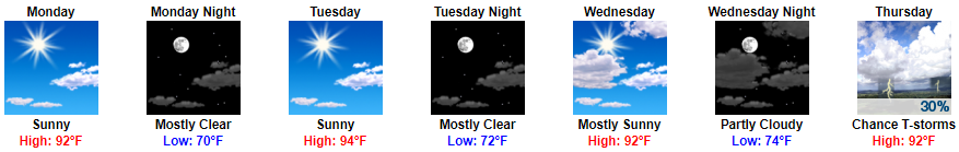
91° Monday, 92° Tuesday, 94° Wednesday, 95° Thursday, and please be kidding no we are not kidding 96° Friday.
These are in the shade temps. So if you’re in the sun, obviously, it’s going to be hotter than that.

90° today, 91° Monday, 92° Tuesday, 94° Wednesday, 95° Thursday, and please make it stop 96° Friday.
Humidity will be “Uncomfortable” today through Thursday.
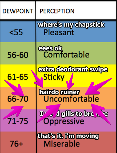
By Friday and Saturday, humidity will be “oppressive.”

Today’s dewpoint stayed in the low 60°s.
It was almost, can I say, comfortable? The warm, kind embrace of a summer day.
Tomorrow….
Wait, what’s that mean for this week? How’s it looking?

Today will be the nicest day of the week. Low 60°s dewpoints = low humidity, but it’ll still feel like summer with a high near 90°.
Humidity will increase every day. Today will be on the low end of Sticky, but Monday-Wednesday it’ll be Uncomfortable:
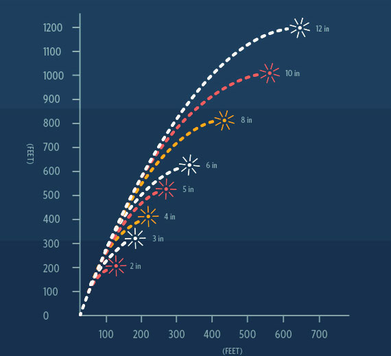
Most fireworks only fly about 1,200 feet up.
Models think “LCL levels” will be low tonight, meaning clouds should be closer to the ground. Some models predict cloud levels as low as only a thousand feet.
You must be logged in to post a comment.