
The official high at BNA today was 96°. We briefly reached 97°, but we were not there long enough for it to be official. The heat index got up to 106°.
Tonight’s rain event is mostly over. You have to look east or west for the heavier stuff. Here’s what the radar looked like at 8:00 PM.
Lots of rain west and east of us. Very little for us. pic.twitter.com/5ONoViFmRJ
— NashSevereWx (@NashSevereWx) July 24, 2017
Those west of downtown saw lightning, hail, and wind in a strong storm around dinnertime.
@NashSevereWx amazing lightning near west Franklin! pic.twitter.com/pxJ9tdqTGd
— Andrew Fromm (@FrommSongs) July 24, 2017
https://twitter.com/cbs1177/status/889249615840763905
There was also a tree down on Sawyer Brown Road in Bellevue.
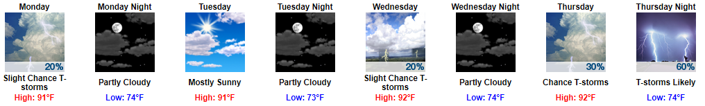
Better Week Ahead
It’ll still be hot and humid tomorrow, but the high temp should “only” be in the low 90°s.
Monday through Wednesday, expect typical summertime mid/late afternoon pop-up shower and thunderstorm chances, but nothing big is expected.
Rain is more likely Thursday and especially Thursday night/Friday (with a chance of strong storms) as a cold front approaches.
If Friday’s cold front delivers, expect below-average temps next weekend.


Categories: Forecast Blogs (Legacy)
You must be logged in to post a comment.