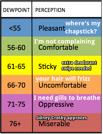
Through 3 PM, 1″ of rain has fallen at BNA.
Rain Continues Tonight
Brief break from the rain as a dry slot in this system rotates through / Radar 3:13 PM pic.twitter.com/bs2SMj6sg9
— NashSevereWx (@NashSevereWx) April 22, 2018
Through 3 PM, 1″ of rain has fallen at BNA.
Brief break from the rain as a dry slot in this system rotates through / Radar 3:13 PM pic.twitter.com/bs2SMj6sg9
— NashSevereWx (@NashSevereWx) April 22, 2018
Radar thru 6:32 AM shows rain inching closer to us.
You can update this radar on our radar/camera/tweets page here.
All models predict rain to work east and wash us out today.
The HRRR model thinks it’ll rain from mid-morning until 10 PM (and likely longer; this model only runs thru 10 PM):
We may see light rain or a few tiny snowflakes sprinkle windshields tonight, overnight, and early in the morning. Here’s the HRRR model:
Neither accumulation nor impacts expected.
This warning is effective from 3 AM to 8 AM Monday.
The front is very slowly pushing the rain east. Radar thru 8:25 AM:
High temps only in the mid-50°s.
Also, windy. Gusts to 20 MPH will drop wind chills into the 30°s tonight.
The HRRR model thinks a light, cold rain may freckle windshields tonight.
Temps around sunrise are below freezing. Some areas are in the mid/upper 20°s.
Temps will rise into the low/mid 50°s as clouds arrive this afternoon.
Our air is really dry. No rain expected today.
A shortwave will cross by after midnight. It may drop us a little rain, but not enough to rain stuff out. Here’s the NAM3 model:
Clouds will gather tonight, forming light rain in the morning. Shortly before lunch, some of the rain may be heavy, at least that’s according to the HRRR model:
A few more showers are possible through the day Monday. It may be enough rain to rain out Monday night games. That will depend on the field.