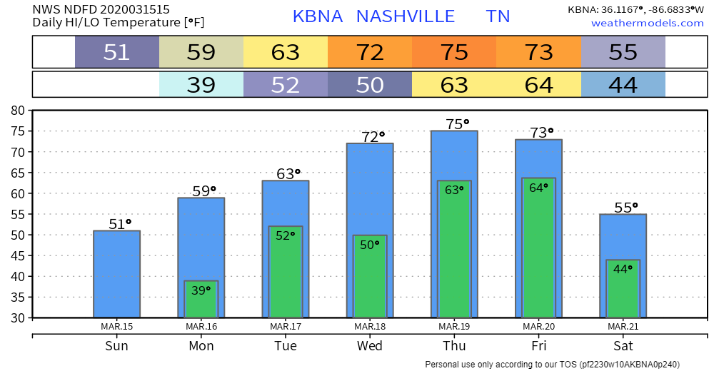
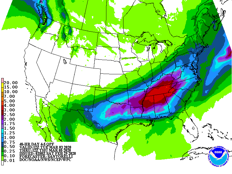
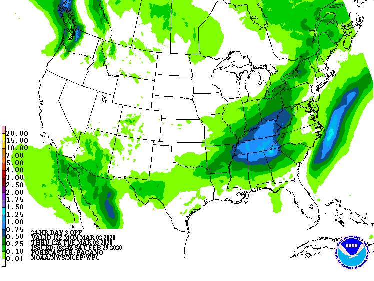
Tornado rating info and other comments, then the forecast - going to get cold, next rain event early next week.

Preliminary Tornado Rating Map; This Doesn’t Include the EF-4 in Putnam County.

It was one supercell producing at least two strong tornadoes.

Our tornado was rated EF-3. Ratings refer to the highest damage reported; this one had EF-0, EF-1, EF-2, and EF-3 damage at various points, but it’s called “EF-3” because that got the highest rating. EF-3 damage was in Germantown, Donelson, and East Nashville. Here’s the zoom on Nashville/Davidson County: read more

Less Rain! & I Respond To Party Pooping Allegation.

The first line in yesterday’s blog was

4″ to 6″ of rain (some may see a bit more) is the current forecast from Sunday night through Wednesday; however, timing and rainfall totals are uncertain because models disagree. We may need to decrease or increase these totals. read more

Heavy Rainfall Concern Early Next Week

Headlines

  • 4″ to 6″ of rain (some may see a bit more) is the current forecast from Sunday night through Wednesday; however, timing and rainfall totals are uncertain because models disagree. We may need to decrease or increase these totals.
  • Flooding is possible and rises on area river, streams and creeks are likely by Tuesday night

Beautiful Weekend; Mild Temps All Week

No concerns for any outdoor weekend activities.

Then Rain Arrives, 3 Days Of It, Starting Monday.

Total rainfall Monday around 1″.

There is a chance for some strong storms on Monday and Tuesday with instability on the rise, but heavy rainfall is the main concern. read more

Do not panic, an update on today’s snow.

Snow should continue into the lunch hour. It should end by early afternoon.

Snow is only expected to stick mainly to grassy areas. Temps this morning are mid 30°s north of I-40. Temps are between 32° and 35° south of I-40. read more

Inconsequential Light Rain/Snow Mix Possible Thursday Morning

Up to 51° Wednesday afternoon. No rain. All eyes on Thursday morning when a band of light, cold rain mixed with snow should move in. It will arrive Thursday morning and there will not be much of it. Best rain/snow mix potential is in Will Co but although less likely in Nashville, it’s possible in Nashville. We may not see any precip at all because the system is weak and passing mostly south of us. read more

Lighter Rain this Week. Pretty Quiet. And a few notes about rainfall totals and low/no snow potential.

Roller coaster temps this week.

Light rain possible but not guaranteed tomorrow. HRRR model predicts tiny showers mid/late afternoon under 0.1″, and not everyone would get them:

Euro thinks we’ll be cloudy, but not raining. If it does rain there won’t be enough rain to cancel anything. read more

Severe Threat Over, Flooding Concern Remains, Much Colder Next Few Days.

Our severe weather risk is over, but flooding concerns remain. NWS-Nashville issued an Urban and Small Stream Flood Advisory for the middle of Nashville through 8:45 PM.

Light rain will linger then end sometime before midnight. We’re watching local creek and river gauges and will tweet any flood warnings issued by NWS-Nashville. It can take hours for flooding to occur. read more

Heavy Rain Monday & Wednesday. Flooding Concerns. Storms Possible Wednesday.

Windy, otherwise beautiful Sunday. High 59.

Rain incoming. Heaviest Monday, then again Wednesday & Wednesday night.

Monday’s Rain

ETA early Monday morning before the AM commute, lasting off and on into the evening, but as far as we can tell, mostly “on” during this time. read more

Flood Watch Now thru Thursday Morning, Splat:Melt Snow Friday Morning.

Flood Watch

More rain is coming, off and on today (Wednesday), most of it this afternoon and tonight.

HRRR model noon Wednesday to midnight Wednesday night

Between 1.25″ and 1.5″ expected through Thursday morning. NWS-Nashville issued an Areal Flood Watch initially for Nashville. Will Co was included in the Watch this morning. read more

Shorts - Sun - Rain - Rain - Rain - Snow? (meh) - Rodent Shadow Rant

I am wearing shorts today and tomorrow. Try and stop me. (Seriously stop me, #birdlegs).

Up to 66° today, 69° (nice) Monday. Breezy both afternoons.

Monday afternoon, clouds roll in. Late Monday night our weather week goes straight in the read more