
Yesterday’s forecast had wins (HRRR timing on Will Co storms, damaging straight line wind threat) and losses (SPC did not mention hail yet Will Co saw 1″ hail then that storm blew into Marshall Co and dropped 4″ hail on Chapel Hill).
David
Heat & Humidity, Rain & Storm Chance Tuesday
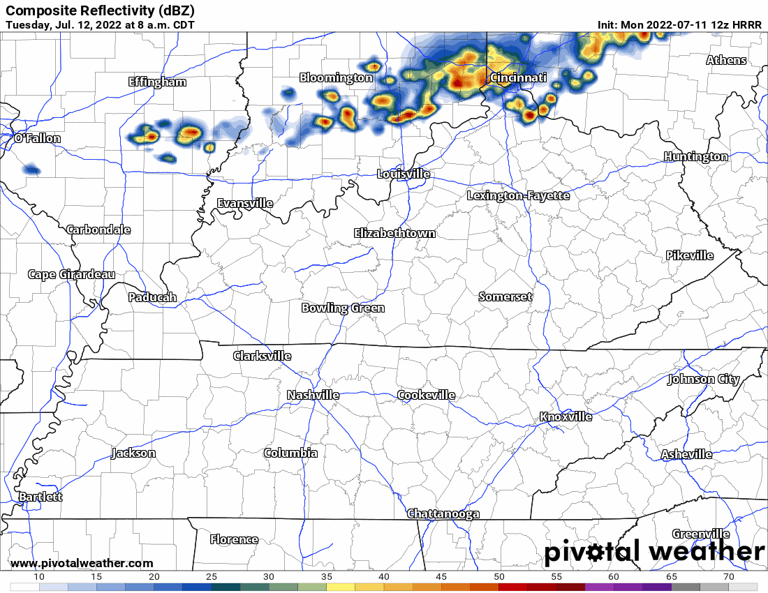
HRRR model thinks a line of rain and thunderstorms will swing out of KY Tuesday (tomorrow) afternoon but fizzle before they arrive here.
Then — right around sundown Tuesday — it thinks storms redevelop and roll off and on until wee hours Weds.
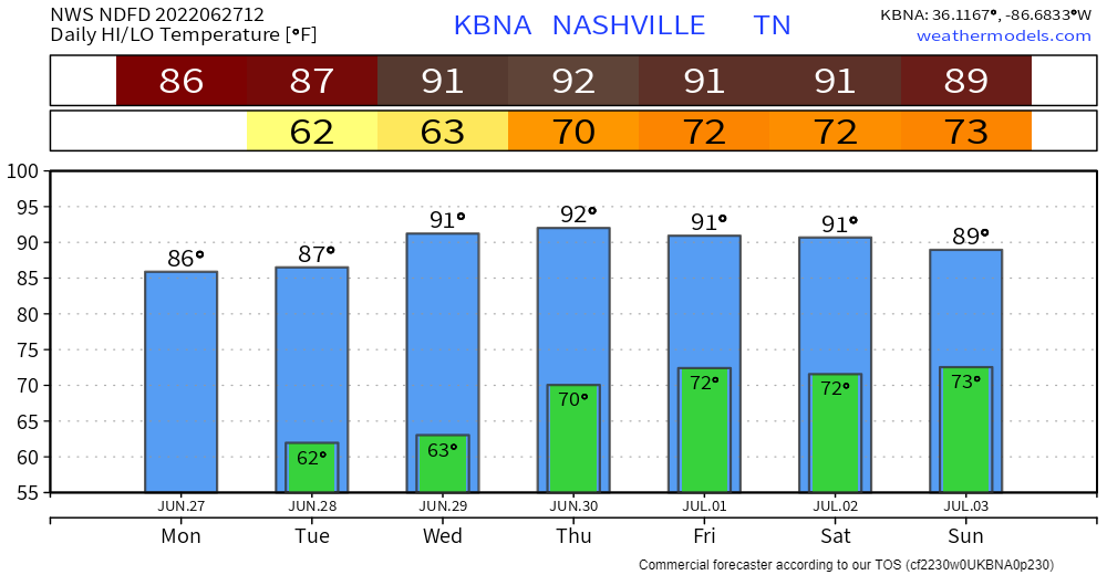
Begone, These Two Streaks: 70° Dews & Dry Grass Views, So You Know You’re All Right

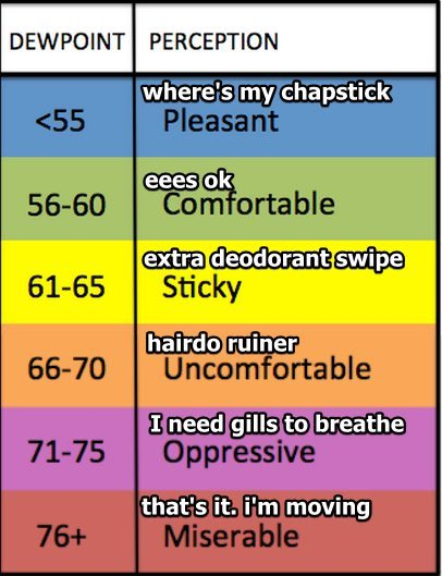
Storms and showers east and south today, I think we stay dry. Humidity also dropping, ending the streak of sweat, in hopelessness and rage, 70° dewpoints delivering oppressive humidity. Dewps today “only” sticky/uncomfortable, mid to upper 60°s, yay? It’s not football weather but at least it snapped a 120 hour 70°+ dewpoint streakdepicted in blue below, a message straight to your soul:
Wattery Szn

“Wattery” is a three tiered dad pun (which I will now ruin for the sake of clarity: lottery as in who knows who will win – maybe nobody, watery as in rain we need, watts as in electricity as in lightning), deal with it.
Humidity Is Way Up, Pop Up Storm Szn Begins Today, Much of Nashville Now In Moderate Drought
The dewpoint jumped from 58° at 5 AM to 68° at 9 AM.
Foreseeable future afternoon highs are now stuck in the low/mid 90°s.
Storms may pop up this afternoon. High pressure will fight storm formation but a few cells may push through. Don’t know exactly whether, when, or where it’ll happen.
Pop Up Storm Lottery Szn Ahead — But Not Much Rain

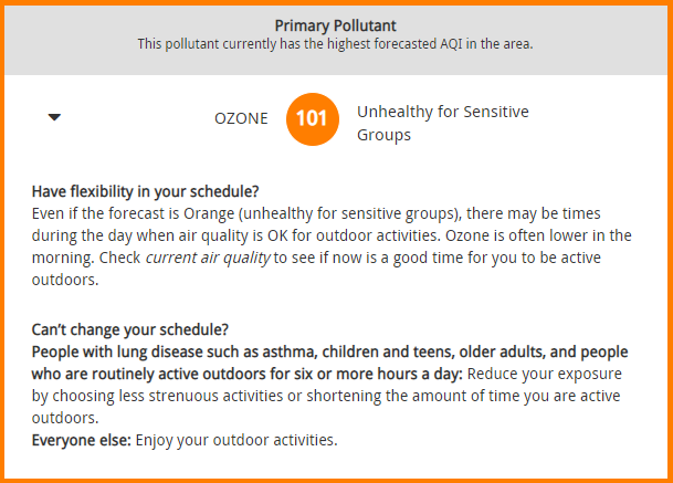
Air Quality Alert today — impacting sensitive groups (asthma, young/old, etc.)
Abnormally-dry predrought continues. We are 3.18″ below normal for June, but 2.66″ above normal for 2022.
Few Great Days. Summertime Pop Up Rain/Storm Szn Returns Just In Time For The Weekend

Comfortable humidity and temps Monday and Tuesday, let’s goooo.
Humid, summertime airmass arrives Thursday morning and sets up camp. Temps right around and slightly above normal for late June with humidity increasing from Comfortable to Sticky. Humidity will be Uncomfortable Friday through the weekend.
A Little Rain & Heat Relief Sunday-Monday

(If it is your birthday I got you “at least it’s not eleventy billion degrees today” and this birthday message).
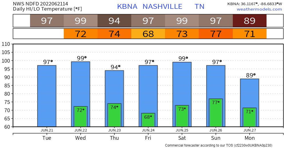
Temps today lower than yesterday’s streak snapping (almost ten years without hitting 100°) and June 22-record-breaking 101°.
“To go 100, or not to go 100 at BNA, that is the question” –@NWSNashville
BNA last hit 100° July 8, 2012. We might hit 100° this afternoon. For several days forecasters have gone back and forth between 99° and 100° for the high. The latest data supports 99°, but 100° will be in reach. If we make it to 100° we would only tie the June 22 record set in 1988.
First Day of Summer: Heat, Slim Rain Chances, Relief in Sight Maybe?
HEAT
Summer officially began early this morning.
This streak of near 100° temps will be a dry heat — not Vegas dry, Nashville dry — except for Wednesday when the dewpoint jumps up from the Comfortable to a Bit Sticky into the Uncomfortable area. That’ll send the heat index to 102°. Rest of the week the temp and heat index will be close together.
You must be logged in to post a comment.