Happy hump day Middle Tennessee! Temps warm up to around 70 today. One thing we’re watching…Warm temps + dry + wind = fire weather concerns. However, with the rain we’ve had recently, we shouldn’t have any major issues. But, it’s something to keep in mind if you were planning to burn a brush pile today.
Month: April 2022
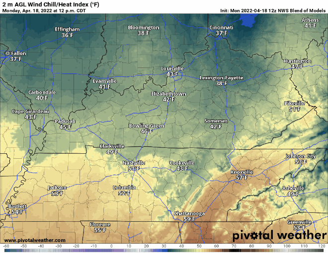
Showers Tomorrow Night, Then Warming Way Up
Someone Ordered A Frost Advisory
We’ll warm up this afternoon as skies clear a bit. Pleasantly cool today.
Tomorrow morning we get close to freezing.
Lows tomorrow morning in the mid to low 30s. Patchy frost is possible. A Frost Advisory includes Davidson Co, not Williamson Co. Possibly (one of) the last frost(s) before the growing season. Stick with it and cover your plants! They will greatly appreciate it.
Showers Later This Afternoon & Tonight; Rain Wednesday PM
Showers from this morning should dissipate as we head into the afternoon. This lull in rain will be the best time for any easter egg hunts today. HRRR thinks showers pick back up later into the afternoon, with a more steady rain this evening. You might hear a few rumbles of thunder, but nothing to worry about.
No Thunder Rolling Tonight, Rainy Easter
Rain has moved out and we will (probably) stay dry today. Temps will reach the upper 60’s, not bad for a Saturday in April.
Garth Brooks looks all good to go tonight, no lightning or thunder concerns. NAM 3k model has some light showers this evening, HRRR model has no such showers. If I had to guess, I’d side with the HRRR, but it would be unwise to rule out another model solution. Looks as if you and your friends will not be in low places tonight.
Showers Today, Storm Threat Tonight
Cool and Dry (For Now); Some Rain This Weekend
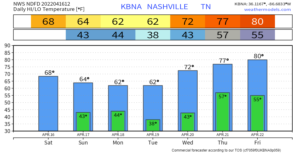
The cold front associated with yesterdays storms just passed through our area. This leaves us a little cooler for the rest of the week. Temps cool to the mid 60s by the holiday weekend.
We’re taking a short break from the rain. Today and most of tomorrow will be dry. Next chance for rain comes in Friday evening. GFS and Euro models scatter showers around town Friday evening after dinner time and continue through the overnight hours. The HRRR has a higher resolution take and shows the rain getting here after midnight Friday night:
Severe Weather Risk Tonight
Another Stormy Wednesday, Severe Storms Possible
TONIGHT – OVERNIGHT – WEDS MORNING
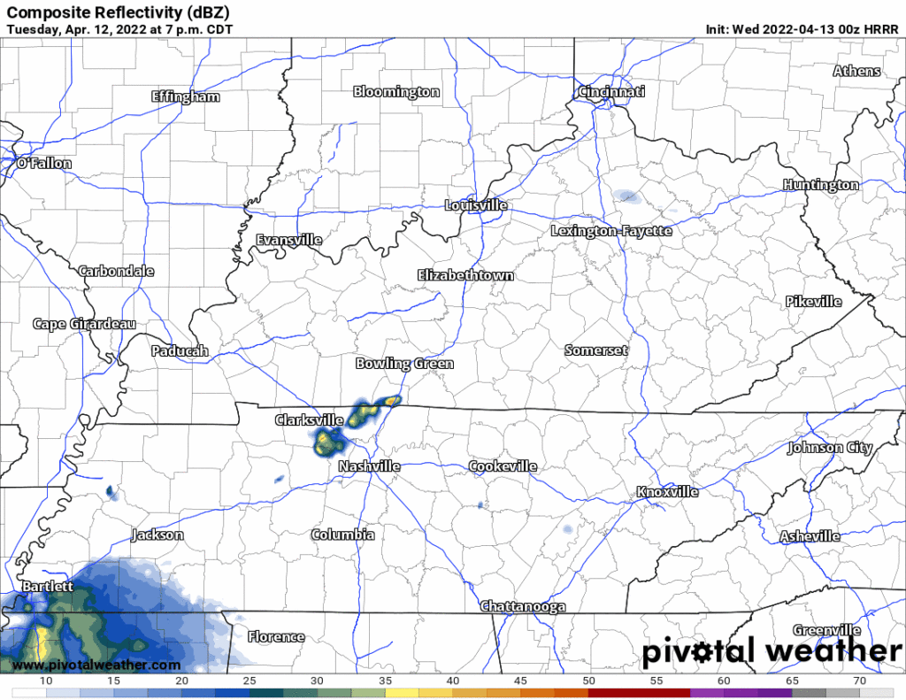
- Scattered rain will be off and on late Tuesday night through Wednesday morning. Lightning and gusty winds possible. Not worried about tornadoes and not worried about severe straight line winds. Here’s the HRRR model through noon Weds:
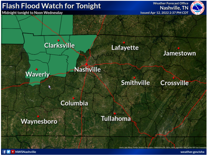
- We’re watching for flood potential for this rain tonight – Wednesday morning. That concern is mostly W and NW of us. Yes we got a lot of rain in the last 24 hours. It wouldn’t take much more to push creeks and streams back up. But this doesn’t look like enough rain to raise overnight/morning flood concerns. We’ll see. There’s a Flash Flood Watch just to our west and northwest.
SEVERE SYSTEM DEVELOPS OUT WEST WEDNESDAY
- Quiet Wednesday afternoon.
- West of us, during the day Wednesday, a significant severe weather event will be ongoing.
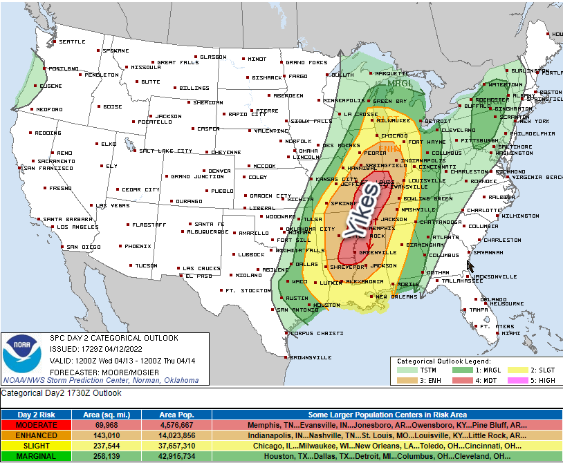
SEVERE SYSTEM GETS HERE . . . BUT HOW BAD WILL IT BE?
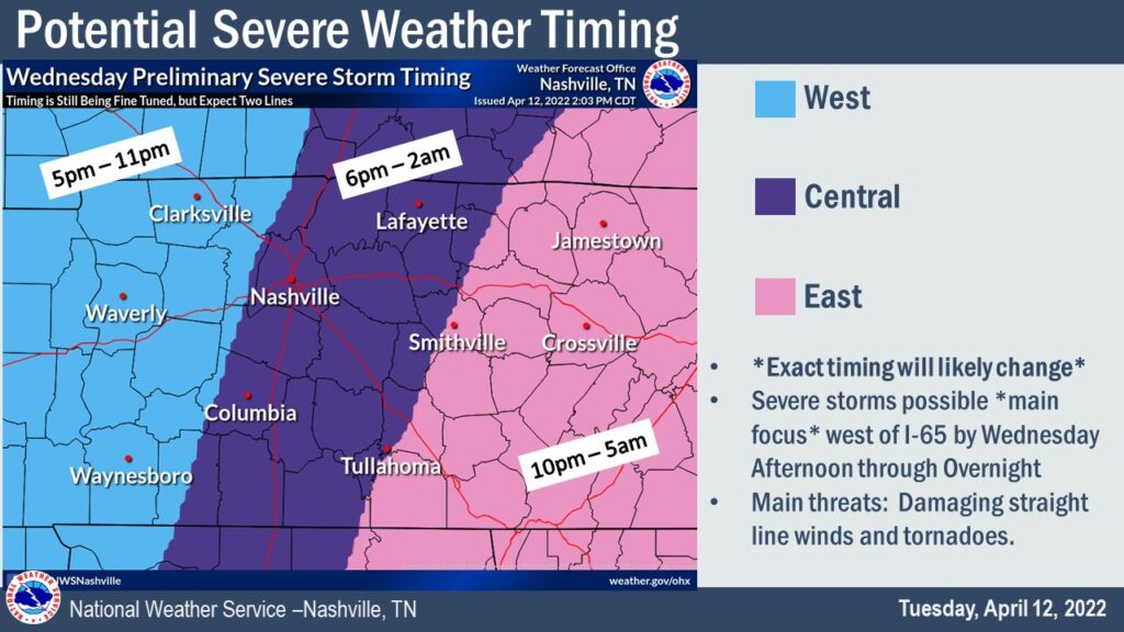
- That significant severe event will congeal into one or maybe two lines. It will move east into Davidson and Williamson Counties. ETA could be as early as 6 PM. It could be as late as just after midnight Wednesday night.
- The initial line should carry the primary severe storm threat because it would arrive with the highest CAPEs and shear.
- So if there are two lines, the first would arrive here late afternoon/early evening and carry the higher straight line wind, hail, and tornado threat. If a second line comes in behind it closer to midnight it would be primarily for damaging straight line winds (tornado less likely with the second line because the first line will have used up the main source of storm fuel).
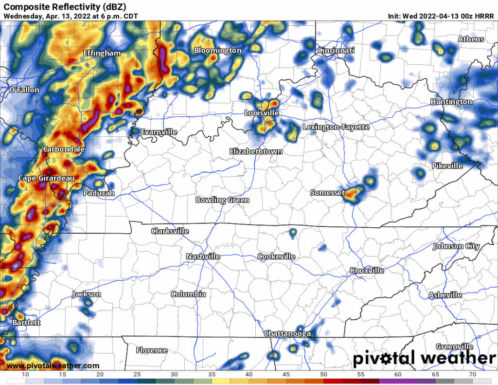
- Or, it’s possible there will just be one big ole line. Here’s what the HRRR shows, just one line, with a 9-10 PM arrival.
- The initial (only?) line will deliver probabilities for damaging straight line winds (30% probability within 25 miles of you), large hail (5% probability within 25 miles of you), and tornadoes (5% probability within 25 miles of you). Flooding is also possible but the line should move quickly enough to reduce the probability of a significant flash flooding event.
- The above run of the HRRR shows the line weakening — perhaps weakening significantly — as it arrives here 9-10 PM. That would be outstanding if it happens. But if the line arrives earlier (closer to 6-7 PM), it should be tapping more storm fuel and be stronger. Models have been going back and forth on an early evening vs late evening event. Either could happen.
- Know today where your safe space will be tomorrow night. Do not leave yourself uninformed, vulnerable, and far from shelter should a warning be issued. Questions? This link may help.
- This forecast may change, especially the timing, so check our Twitter and other reliable sources of information for updated/new information.
Quick References:
Weather changes constantly.
Follow @NashSevereWx on Twitter for any changes to this forecast.
Live coverage during tornado and severe thunderstorm warnings:
Look good.
Support the mission.