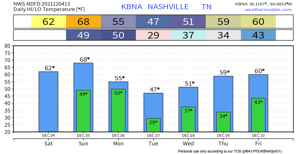
Temps dropped like a rock overnight thanks to yesterday’s front. The high today will be in the mid 40’s, so yes it is chilly. Lows overnight should stay just above freezing, but a few spots may get down below freezing.
Month: December 2021
Storms are Out... Now Bring On Cold(er) Temps
Storms moved out pretty quickly this morning. Any weather warnings and special statements have appropriately been retired. Mostly clear skies and rain-free for the rest of your day.

Don’t look now, but temps are temps are going to drop FAST throughout today into the overnight. Highs are likely what you’re feeling right now–just shy of 50 degrees or so. Fairly breezy for the rest of today, so wind chill comes into play. Lowest chills right around 20 degrees before sun-up tomorrow!! High for tomorrow squarely in the 40s. Bundle up (for now).
Heavy Rain Early Monday Morning, Low Probability Damaging Straight Line Wind &/Or Tornado Threat
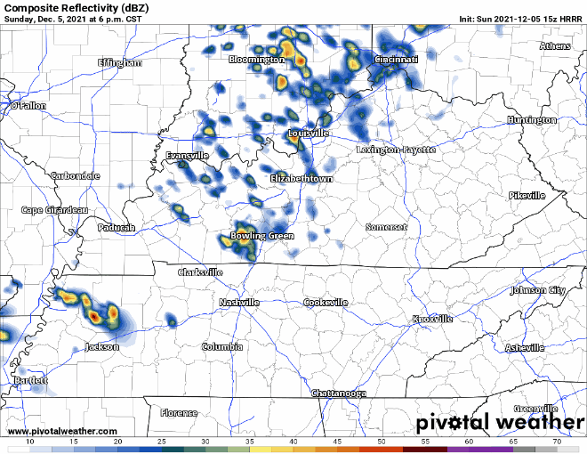
Let’s Talk About Rain/Storms Late Sunday Into Monday Morning.

Unseasonably Warm Today; Weekend Rain/Storm Chance
Warm Temps Through the Weekend; Rain this Weekend
Our unusually warm start to December continues today. Highs are up in the low 70’s. The record for Nashville for today is 75, and the forecasted high is 73… it’ll be close. The warm temps aren’t going anywhere for a bit, we’ll be in the 70’s again tomorrow and in the 60’s until Sunday. A cold front this weekend will nosedive the temps for next week. Don’t throw away your sweaters… cool temps will return.
Warm First Day of December; Sprinkles this Evening
Happy first day of Meteorological Winter and December (editor’s note: not real winter. That comes December 21. Carry on.)! It’s not beginning to look or feel like Christmas at all for the rest of the work week. Temps hit the upper 60’s today which is about 10 deg above average. The warming trend continues till Friday eventually heating up to the low 70’s. It’s definitely going to be one of those “heat in the morning and AC in the afternoon” kind of next couple days.