Merry Christmas! Flood Watch!

Current Radar 

Merry Christmas! – Heavy Rain, Areal Flood Watch, Thunderstorms Also Possible – High 65°

Heavy rain is here.

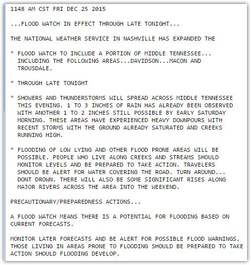
An Areal Flood Watch is now in effect for Davidson and Williamson Counties.Here’s the official text of the Watch:

Flooding potential seems limited by the unexpected arrival of a cold front: read more

Heavy Christmas Rain, Thunderstorms With Very Low Severe Potential

Current Radar 

Christmas Day – Heavy Rain, Areal Flood Watch Williamson Co., Thunderstorms Also Possible – Early 61° High 65°

Heavy rain is on the way.

Flooding potential remains high in areas in and around the Watch area. Here’s the official text of the Watch:

Rainfall will be heavy. Forecast soundings show all time high precipitable water values for Christmas Day: 1.7″. Think of precipitable water like this. If you stuffed a towel in a giant tube, sent the tube straight up in the air through the atmosphere and let it soak up the moisture, then squeezed it out, you’d get 1.7″ of water. read more

The Threat is Over!

Current Radar 

Tonight’s Tornado Watch is Over for Davidson Co. The threat has passed Williamson Co.

Active weather remains a concern Friday and Monday or Tuesday of next week, although likely not nearly as worrisome as it has been today.

Anyway, I’m exhausted, no energy to update the forecast here on the website. read more

Severe Weather Today: Upgrade To Moderate Risk

Current Radar 

Severe Weather Risk Increases

TN_swody1-2

The NOAA Storm Prediction Center has upgraded our risk from Enhanced to Moderate – level 4 of 5 on the scale of risks for severe weather. Updates to their outlook include adding wording for long track tornadoes. They are calling this a potential outbreak of severe thunderstorms. Nothing major has changed in terms of thunderstorm timing, but they believe that the threat for severe weather has increased. read more