Little Rainy, then a Drying & Cooling Trend

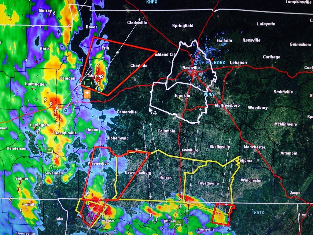
We dodged a bullet yesterday. The Cumberland Electric Company Reported that over 2,000 people in Clarksville lost power last night — in the area with a tornado signature on radar.

power out

Today the NWS is surveying what appeared to be a long-track tornado-producing supercell which moved across western Middle TN late Monday afternoon. read more

Whew! OK, What’s Next?

wiggle animated GIF

Well, that was close. Thankful to escape with only a few reports of 60 mph winds after seeing this at 5:15 PM:

Other communities to our W and NW were not so lucky.

The Tornado Watch is set to expire at Midnight. It’ll likely formally be cancelled before then. read more

Tornado Watch Until Midnight

Current Radar Loops:

At 3:56 PM, the NWS posted this:

Keep an eye on those storms flying out of N Alabama.

Tornado Watch Until Midnight

Here is the Watch Information. Notice the Hazard Likelihood at the bottom: read more

Tonight’s Severe Weather: What & When

Current Radar Loops:

Severe Weather Likely Tonight — High 82°

3:00 PM Update

SPC’s latest update:

2% to 5% probability of a tornado occurring within 25 miles of you:

15% to 30% probability of a 58 mph or greater wind gust occurring within 25 miles of you: read more

All Eyes On Tomorrow Night: 2 Potential Rounds of Storms

Summary: Windy Monday – Severe Weather in 2 Rounds – Round 1: late afternoon/early evening Monday – Round 2: main squall line ETA 3 AM to 6 AM Tuesday morning – Damaging Winds, Torrential Rain, Tornadoes possible in both rounds. read more

Severe Weather Possible Today, Likely Tomorrow

2:42 PM The National Weather Service issued a Special Weather Statement for both Davidson and Williamson Counties for Monday into Tuesday morning.

NWS statement

2:30 PM The Storm Prediction Center put out a Mesoscale Discussion that included Middle Tennessee. It has confirmed, however, that the system has missed us to the east. read more

Rainy Weekend; Stormy/Severe Monday

Current Temp

Current Radar Loops

Saturday – Mid 60s – Rain

Rain will be here mid-morning, and should continue off and on through most of the afternoon and evening. The HRRR model thinks there may be a break in the rain by mid afternoon. If you have outdoor activities planned, I suggest you just watch for gaps in the rain on the above radar loops. read more

Trying to Tackle When/Where/What re Weekend Rain

Current Temp

Current Radar

Today Heavy Rain– High 76°

This morning’s rain is from a wave bringing instability, moisture, and warm temps — atypical for October. The wave can be seen tracking to the northeast into Nashville on the NAM’s 10 AM vertical uplift map. read more

Last Dry Day This Week

Dry Today — Rain Chances Return Thursday — Rain Likely Friday & Through the Weekend

A line of noisy thunderstorms rolled through Middle Tennessee late last night. For the heavy sleepers this isn’t a problem, but for wx nerds and light sleepers it is. Justin Bruce from WKRN had an excellent point: read more

Last Day This Week.

A line of noisy thunderstorms rolled through Middle Tennessee late last night. For the heavy sleepers this isn’t a problem, but for wx nerds and light sleepers it is. Our friend Justin Bruce from WKRN had an excellent point! read more