Less Humid but It’s Not Yet Time To Celebrate the Vile Brew

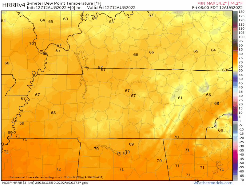
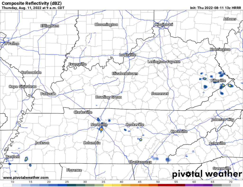
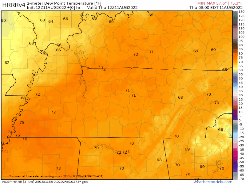
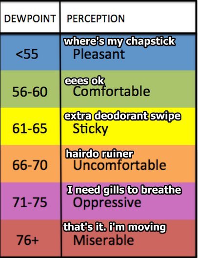
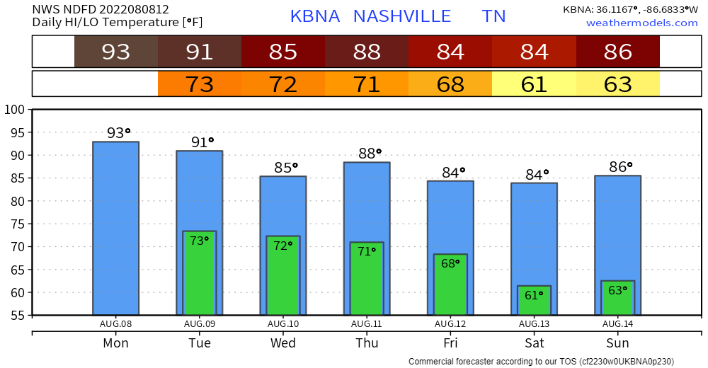
A north wind is carrying drier, less humid air into town. Check out these dewpoints today through Sunday morning:

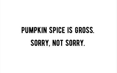
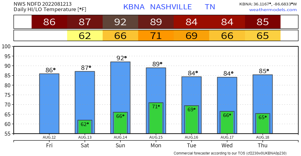
It’s not Fall tho, so delay your PSL excitement, temps are still Summer:

But it’s OK to celebrate this Big Weather Improvement. NWS-Nashville suggested leaving your windows open tonight! read more

Dodge Showers, Then Humidity Relief

70°+ dewpoints are oppressive and we’ve been stuck swamping in them for weeks. Including this morning.

SOON, THEY GONE!

First, we have to dodge a few mid-day downpours:

  • HRRR model has more showers (see below).
  • NAM3 and other convective models have fewer showers covering less of us.
  • Cannot totally rule out a few lightning strikes but think this is mostly a rain event, and only for some of us.

After today, it won’t rain much for a while.

  • Humidity will drop. It’ll take a while for north winds to deliver that crisp(er) air from Indiana and Ohio.
  • By Saturday you’re going to be doing popular tik-tok things with your friends.
  • Watch the swamp get pushed out:
  • We go from Oppressive to Comfortable/Sticky for at least about a week or so.

The Real Hazard is Not *Exactly* Knowing the Future

Storms are likely today. Even more than yesterday! Rainfall amounts will be spread unequally and without reliable ETAs. Looks like most if not all of us will get something. It’s a Wattery, with many more winning numbers than usual. read more

2sday Feat. Two Days With Some Rain & Storms Around

Rain and storms are likely today but the question is when?

  • The overnight models were all convinced storms would form mid/late afternoon and last into early evening.
  • Latest NAM/HRRR models have the afternoon quiet with storms forming after dark.
  • It makes more sense that they would form late afternoon to dark, say like around 4 PM to 8 PM. We’ll see.

Storm hazards today/tonight:

  • Heavy rain in spots, with flash flooding possible; WPC has a 10% to 20% probability of flash flooding within 25 miles of you
  • CG (cloud to ground) lightning
  • Low probability of damaging straight line winds in a few isolated spots
  • I suppose we could see some small hail but that’s also unlikely
  • Not worried about tornadoes.

Rainfall should be heavy in spots but unevenly spread, like what happened yesterday thanks to @SoccerMoses:

https://twitter.com/SoccerMoses/status/1556841249398726658?s=20&t=QOb6Lzz2GOmdqBzK6-Eb-Q

Everyone on the interstate was winning the Wattery in that moment. Thank you Soccer Moses! read more

Four More Days Of Wattery, Then Suh-weeet Relief

Classic Wattery Today Through Thursday.

Monday: Probably Nothing.

  • Spilled paint below is just a bunch of models on one display suggesting rain is Quite Unlikely (but maybe still possible) today.

Tuesday: A Bit More Likely.

  • HRRR model has rain Tues morning and again late afternoon/early evening, see below.
  • Rain may be excessive. 5% probability of flash flooding within 25 miles of you Tuesday. Poor eastern KY, they keep getting hammered by rain.

Wednesday: Likely the Wettest, Stormiest.

  • A continuous rain is unlikely, but expect rain off and on during the daylight hours.
  • Flash Flood probability straddling the 5% to 10% and 10% to 20% line. Average rainfall around a half inch, but some will get more, others much less.
  • Severe weather unlikely in the classic sense (large hail, tornadoes, long tracked damaging straight line wind swaths), but like we’ve seen this past weekend in Donelson, microburst winds will be possible as storms collapse and bring a lot of sudden straight line wind with it.
  • CG lightning also likely in these storms. Don’t be far from lightningsafe enclosed structures.

Thursday: One More Wattery Day This Week

  • Chances meh, so more water losers than winners.
  • Last day of big humidity?

Friday – Weekend: Sweet Relief

  • Humidity drop! We’ve been stuck with 70°+ dewpoints for a while, we’re all getting used to it. Dewps drop into the 60°s and even into the upper 50°s Saturday, before re-rising back near 70° late Sunday/Monday. Far from Fall Weather but still pretty nice for mid-August.
  • No rain in the weekend forecast (so far!).
  • There’s still time for the model data to change.

Quick References:

Weather changes constantly.
Follow @NashSevereWx on Twitter for any changes to this forecast.

Live coverage during tornado and severe thunderstorm warnings. read more

It’s The Sunday Edition. Readers Demand More.

A long time ago – very long even! – a man got in an airplane, went up instead of sideways, flew to the dang moon and walked on it. So here in 2022, it is reasonable for us all to expect in this here age where George Jetson Has Been Born that I could possess easy answers to your reasonable, common, simple weather questions like: when will it storm on my flying car today? read more

No Genie, But Genuine Answers For Rain/Storm Chances This Weekend

So many questions, so many variables, so many different outcomes, few answers. This blog may not contain the answer(s) you are looking for, but it’s the honest answer. The Wattery is random. If a genie gave me three wishes, my first wish would be to have the knowledge of when/where the Wattery would strike. But since I don’t personally know any genies, here I am giving you vague, yet honest answers. read more

Trying To Dodge Uncertainty With Daily Rain Chances

Rain just to our west this morning. HRRR model (below) thinks it slides a little this way during the afternoon and some of us may get some rain and lightning before it pushes north. For tonight, the HRRR thinks more Wattery style showers/storms pop-up sometime this evening. read more

Can’t Shake The Uncertain Rainy Pattern

Another hot + humid day with the heat index maxing out near 100°.

HRRR model (below) think the showers/storms in Arkansas and West TN slowlyyy make their way here, if they make it at all. ETA would be sometime in the evening. HRRR model doesn’t think there are any Wattery chances but cannot rule one or two out. No widespread severe weather is expected but a storm or two could have some strong straight-line winds and some heavy rain. read more

Playing The Wattery Everyday

Muggy today, high of 93° paired with dewpoints in the low 70’s will send heat index close to the triple digits.

HRRR model thinks only a couple winning Wattery tickets will be sold today. Your guess is as good as mine as to where those winning tickets may be. No severe weather expected, but a storm or two could have some heavy rain and strong winds. read more