Record Heat Forecast Today, Fall Tomorrow, Rain Sunday (?)

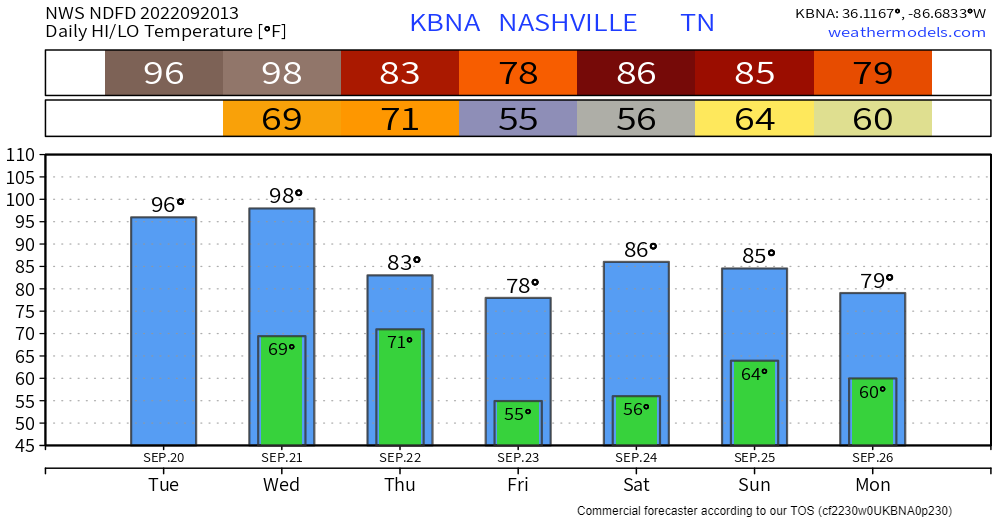
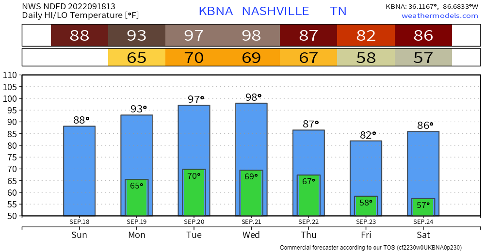
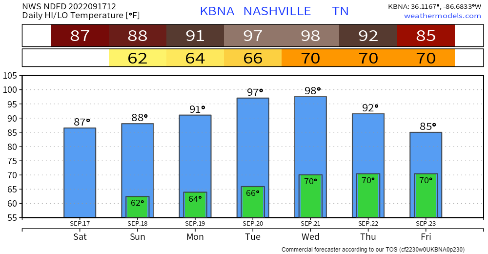
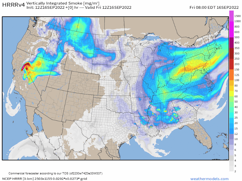
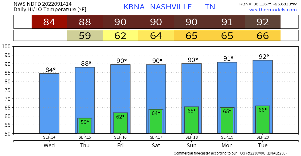
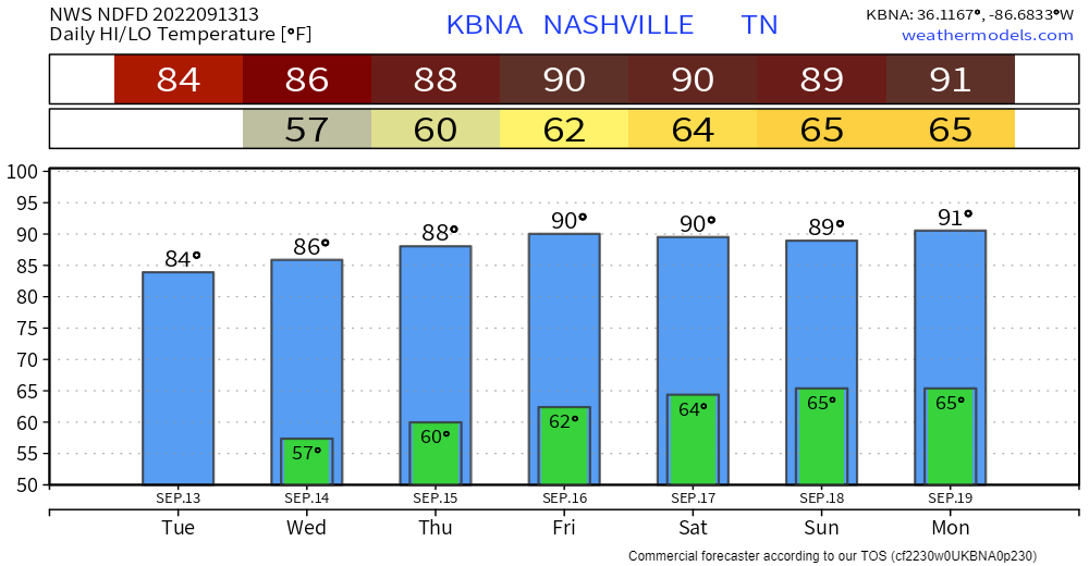
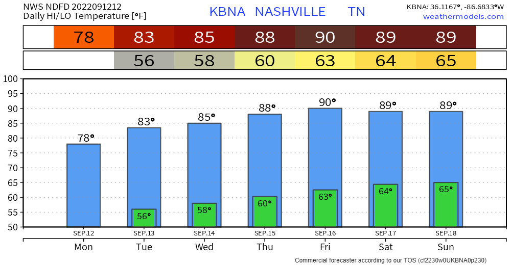
97° is the record high September 21 temp. We should break this record. The official forecast high is 99°.

(Some were asking if we would hit 100° but models aren’t so sure we’ll get that far over 97°. Clouds may slide over the official observation sight. The heat making ridge may be weakening just a bit). read more

Humidity Up, Temps Nearing Record Daily Highs. Relief Thursday.

The record high for today /checks calendar/ September 20 is 97° (2018). 96° is forecast.

Tomorrow the record is 97° set in 1955. We are forecast to break that record (98°).

Humidity should be higher than previous forecasts. Mid/Upper 60°s dewpoints will drive the heat index to 100° today and 99° tomorrow. read more

A Lot Of Yappening for Not A Lot Happening. There Is A 98° Reference in Here, Sorry.

Moving this morning in our general direction are storms that last night caused Severe Thunderstorm and Tornado Warnings in the midwest. This storm complex is now much weaker and crossing the Ohio River, moving south through Kentucky. Most models think these storms will further decay and then completely fall apart before the Tennessee state line. (A few models predict the system – while weaker – will at least hold its precip and cross into Tennessee along and east of I-65). read more

End of Summer Heatwave

Record highs at BNA on Tuesday (97 in 2018) and Wednesday (97 in 1955) could be tied or even broken.

NWS-Nashville, 9/18/22, AM Forecast Discussion

Hot, but not as humid as the other heatwaves this summer. Dewpoints upper 50°s (Comfortable) / lower 60°s (Sticky) during this End of Summer Heatwave.

There’s little to no hope of rain in the next 7+ days. read more

Upper 90°s Next Week. No Rain in Sight. Hot & Dry for How Long?

Today will be the same as yesterday and the day before. Then things get…worse.

  • The dewpoint will rise a from Comfortable to Sticky starting Sunday, continuing through Wednesday.

Haze, Heat, & About Fiona

Wildfire haze should slightly dim clear skies. Those are controlled burns south.

Heat without bad humidity will build into next week when the heat index (what it “feels like”) might approach 100°. read more

When Will We Fall Down?

It’s been a great weather week. Well, the good times never stay. And the cheap thrills always seem to fade away.

Fall begins at 803 PM in one week (September 22) so you’d expect temps to be easing on down into Autumn range, but, no. read more

Gonna Get A Bit Toasty, But Still Boring.

Boring is good.

A ridge is an elongated area of high pressure. We’ll have one for a while. That means

  • No rain for at least the next 7 days, maybe longer.
  • Temps gradually warming each day, #StillSummer
  • Reasonable, borderline comfortable humidity. Surface winds aren’t pumping that Gulf of Mexico humidity in here, keeping the swampy away.

We will still sweat.

When will the heat break?

Models disagree (shocking, I know).

Euro (below) thinks late next week (Friday the 23rd), the first full day of Fall! read more

Press Conference.

/stands up, stacks papers/

Just one item y’all. We ride. Check this out 👇🏽.

Warmer each day, eventually to 90° because it’s still summer.

I will now take questions.

How Long Will We Ride This Lower Humidity? read more

Nothing To See Here

Today-Tuesday is back-to-back glorious. Temps either side of 80°. Pleasant humidity.

We warm up Weds and should be to 90° by Friday.

Dewpoints should stay below 60° all week. Last week dewps were in the upper 60°s and low 70°. read more