
It looks like a tornado started in Williamson County in the Monticello subdivision, then moved through Cool Springs, into Brentwood and north of Nolensville/Cane Ridge, then Antioch and Percy Priest Lake. It’s not yet clear whether NWS will say it was two tornadoes from the same storm, or one long tornado. It’ll be rated at least EF-1. This is all preliminary and subject to revision.
Tornado Watch In Effect Until 10 AM

Remember, a “Watch” covers a large area and means “be ready.”
A “Warning” (which we will post to Twitter @NashSevereWx — which you can find by clicking the top banner — but not to the blog itself) means take cover: the warned severe weather event is imminent or occurring in a small, specific area.
ETA 7 AM to 9 AM, Give or Take a Few Hours. Damaging Winds Most Likely, Hail & Tornado Also Possible
Quick Look Forecast

Wednesday
What: Damaging Winds (Main Threat), Large Hail, & (a Smaller) Tornado Threat
Storms will form a long line on radar, called a squall line, which will quickly speed through Wednesday morning. They should be packing quite the punch:
- Damaging straight-line winds are the most likely severe weather threat.
- Large hail is the next most likely hazard.
- Less likely, but still possible, is a brief tornado embedded in the squall line.
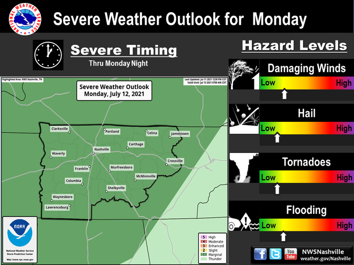
The probability of any of these happening withing 25 miles of you is 30%.
Updated ETAs for Wednesday Morning’s Squall Line with Severe Storm Potential
Quick Look Forecast

A Break in the Rain Tuesday Night as Strong/Severe Storms Build to our West
A significant severe weather event is setting up today and tonight along and north of the Ohio River.

This is the system that will set off storms with severe weather potential for us Wednesday morning.
Focus is On Wednesday: Severe Weather
Quick Look Forecast

Rain This Morning, Lull This Evening
It has been a soggy commute to work and school with showers a few rumbles of thunder. The HRRR model below shows how the rest of the day may play out on radar, and where we might get a break this evening in the wet weather:
Wet Again Tomorrow, Severe Storms Possible Wednesday
Quick Look Forecast

Tuesday Morning Rain
Latest run of the HRRR has showers entering during the early AM hours.

These showers will likely be scattered and continue through the entire day. An isolated thunderstorm or two will be possible as well.
Wet Monday, Wet/Stormy Tuesday, Strong/Severe Storms Possible Wednesday

Rainy Monday
Light rain will arrive while we sleep, and continue through the morning commute. The HRRR model thinks this rain will last through mid-morning:

Other models, particularly the NAM3 model, think the rain could linger off and on into Monday afternoon.
Nice Today, Rain Monday & Tuesday. All Eyes on Severe Weather Wednesday.
Growing Concerns About Storms Wednesday
But first, let’s talk today thru Tuesday.

Sunday
Sun this morning will turn into clouds later today and tonight. The HRRR model shows light rain approaching by midnight.

Expect light rain while we sleep tonight.
Noticeably Colder, Unsettled Weather Next Week
Quick Glance Forecast

Warmer, Rain/Storms To Start the Work Week
Southerly winds and moisture return will “restart” on Sunday night into Monday morning — this will lead to climbing temperatures and increased chances for rain.
It appears the Monday morning commute could be wet. Scattered showers into Tuesday are a good bet, with a couple storms possible but not overly likely. Tuesday, the mercury will approach 70º!
Wednesday is a day when instability will be the greatest, and this could aid in decent thunderstorm development. A preliminary look at CAPE (storm food) forecasts from the GFS show a respectable amount of unstable air on Wednesday at lunchtime:

In lieu of this, the Storm Prediction Center has highlighted a 15% risk for severe weather already for Wednesday:

SPC Discussion:
...lower MS Valley and TN Valley on Wednesday... Strong belt of mid-level flow coupled with increasing low-level moisture will probably support marginal-moderate buoyancy with a strong shear profile. The timing of a cold front appears to converge on Wednesday as it sweeps through the area. Scattered to numerous thunderstorms are forecast, some of which could be severe.
Strong/Severe Thunderstorms Possible Tonight, MUCH Cooler Tomorrow
Current Radar
Windy and Warm This Afternoon
With a max high temperature of 81° this afternoon, we have officially broken the long standing record for the day from 1890.
81° the official high so far today. The previous record was 77° set back in 1890.
You must be logged in to post a comment.