
Quick Look Forecast

A Break in the Rain Tuesday Night as Strong/Severe Storms Build to our West
A significant severe weather event is setting up today and tonight along and north of the Ohio River.

This is the system that will set off storms with severe weather potential for us Wednesday morning.
For tonight, expect mostly dry conditions, with a few off and on showers, but nothing strong or severe.
Wednesday
What: Damaging Winds, Large Hail, & (a Smaller) Tornado Threat
Storms will form a long line on radar, called a squall line, and slam into us Wednesday morning. They should be packing quite the punch.
- Damaging straight-line winds are the most likely severe weather threat.
- Large hail is the next most likely hazard.
- Less likely, but still possible, is a brief tornado embedded in the squall line.
Some Things to Keep In Mind
- Be prepared to respond in the case of a severe weather warning. Know your safe place and since this is a morning event, do not attempt to drive when severe weather is imminent. Those in mobile homes are most vulnerable; if you have a better option, take it.
- This will likely be more of a damaging straight-line wind event than anything else. However, tornadoes can develop quickly along notches and bends in a line of storms. Sometimes, a tornado can occur without a tornado warning. A lot of severe thunderstorm warnings have an extra tag at the bottom that says “Tornado…Possible”.
- Furthermore, severe thunderstorm winds can be just as strong and do the same or more damage as tornadic winds. This means that we treat every severe thunderstorm and tornado warning with the same level of importance, and you should, too.
- Watch the dewpoints. If this forecast is going to bust (meaning, we think it’ll be bad, and it isn’t), one reason may be due to a lack of instability and moisture. All models predicting severe thunderstorms assume we’ll actually have 63°+ dewpoints early in the morning. If we don’t — for example, if the dewpoints are only in the upper 50°s when we wake up — the models will have been way off and this event may be noisy, but not as bad as forecast. When forecasts bust, this is often the reason why. There is some reason to think the line may weaken as it works east.
- If this does turn out to be a tornado producing squall line, remember tornadoes can spin up, drop, then lift between radar scans. Depending on the orientation of the storm winds to the radar, the radar may not “see” the winds very well. There may be damaging winds or (God-forbid) a tornado, even if radar is not seeing it very well. Radar can see a lot, but it can’t see everything. Tornadoes don’t care if radar can detect them or not. This is why you should heed all warnings, and take cover if one comes out.
- It’s possible a supercell or two could form out ahead of the main squall line, but I think that’s unlikely. I just wanted to mention it.
- By no means are we calling for panic, just be prepared, aware, and don’t take any chances. The storm will move through very quickly, letting you get back to your day soon enough. A storm isn’t a big deal unless it happens to you.
When’s This Happening? Well, There’s Uncertainty About That
By midnight, we could see a few supercells fire out of west Tennessee ahead of the main line. Those supercells should move into northwest middle TN on their way into Kentucky, like this one as predicted by the HRRR model:

We do not expect these overnight supercells to be a problem for us. They should miss us to the north.
So, when’s the severe stuff going to get to us? We don’t really know. The are two models giving two different ETAs.
(1) HRRR Model: 6 AM Arrival. The latest run of the HRRR model predicts an intense squall line to show up around 6 AM. The below shows a loop beginning midnight tonight through 7 AM:

The HRRR model thinks storms could be quite severe, despite the predicted pre-dawn arrival, as shown by high values in the Significant Tornado Parameter:

According to this HRRR model, this would be the main storm event of the day.
(2) NAM3 Model: Backing Away from the Lunch ETA: More like 7 AM to 8 AM.
This is the solution the models have had for most of the week, and the solution this model had this morning:

However, the brand new/afternoon run of the NAM3 model predicts the squall line will arrive between 7 AM and 8 AM, almost as if it’s looking at HRRR’s paper and writing down its answers:

Like the HRRR model, these storms will be arriving with plenty of bite, as seen by high values in the Significant Tornado Parameter:

*Keep in mind some of these squall lines like to accelerate and slow down at their own pace. Timing them out is quite difficult.
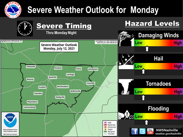
This is the official graphic from NWS-Nashville.

If I had to bet, I’d bet on the early arrival, especially now that the NAM3 model is coming in with an earlier ETA. 6 AM to 8 AM looks like the most likely arrival time, but given the uncertainty in the timing, the 6 AM to Noon window makes a lot of sense to me.
Our Twitter, @NashSevereWx, will have the most timely updates tomorrow morning on this event. Warnings are never posted to this website. You’re encouraged to tune in to your favorite local TV station as the storms approach.
After the Storms
Quoting NWS-Nashville:
Even before the storms arrive, winds will become strong and gusty tonight, and after the storms pass, they will remain pretty gusty as well for least an additional 3 to 6 hours. Once the [cold] front passes on Wednesday, winds will switch from the south to the northwest, and temperatures will fall.
Finally….
This website is new, backed by a new host, and supported by a web professional. This means our web costs have tripled, and as traffic builds, those costs will quadruple. Our costs are monthly, just like yours are, so any monthly financial support we can get goes a long way. Several of you have already pledged to help us out (y’all are awesome!). Here is how you can help:
https://www.patreon.com/NashSevereWx.
If not, it’s cool. We aren’t going to hide our stuff behind a pay wall or anything. Thanks, y’all.
Categories: Forecast Blogs (Legacy)
You must be logged in to post a comment.