
Quick Look Forecast

Rain This Morning, Lull This Evening
It has been a soggy commute to work and school with showers a few rumbles of thunder. The HRRR model below shows how the rest of the day may play out on radar, and where we might get a break this evening in the wet weather:

Severe Weather Potential Starting Early Wednesday
Here is the latest on what we know for the threat of strong storms tomorrow:
Timing
Most models have come into better agreement by now on a morning arrival of the “main line of thunderstorms”. Below is the 3KM NAM, which shows a narrow but solid band of storms making it to our doorstep between 6AM and noon Wednesday.
*Keep in mind some of these squall lines like to accelerate and slow down at their own pace, so timing could change by an hour or two on either end.*

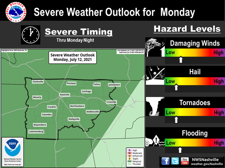
Impacts
From NWS Nashville:
As mentioned above, damaging winds are the main threat associated with this potential svr wx outbreak, but large hail, a few tornadoes, and brief heavy rainfall associated with the stronger tstms can certainly not be ruled out.
On A Scale of Severity, How Bad…?
The Storm Prediction Center in Oklahoma still has all of Davidson and Williamson Counties under an “Enhanced Risk”, 3 out of 5 rating, for severe weather (see more below).
David’s version of the SPC scale places us under “getting concerned”.

A Few Things to Keep In Mind
- Be prepared to respond in the case of a severe weather warning. Know your safe place and since this is a morning event, do not attempt to drive when severe weather is imminent. We can’t write a late excuse for you to work or school, but being sheltered is better than being stranded.
- This will likely be more of a damaging straight-line wind event than anything else. However, tornadoes can develop quickly along notches and bends in a line of storms. Sometimes, a tornado can occur without a tornado warning. A lot of severe thunderstorm warnings have an extra tag at the bottom that says “Tornado…Possible”.
- Furthermore, severe thunderstorm winds can be just as strong and do the same or more damage as tornadic winds. This means that we treat every t-storm and tornado warning with the same level of importance, and you should, too.
Additional Things to Keep In Mind, from David:
4. Watch the dewpoints. If this forecast is going to bust, one reason may be due to a lack of instability and moisture. All models predicting severe thunderstorms assume we’ll actually have 63°+ dewpoints early in the morning. If we don’t — for example, if the dewpoint is only in the upper 50°s when we wake up — the models will have been way off and this event may be noisy, but not as bad as forecast. When forecasts bust, this is often the reason why.
5. If this does turn out to be a tornado producing squall line, remember these tornadoes can spin up and back down in between radar scans. Also, some of the winds may not be seen very well by the radar, so there may be big winds or God-forbid a tornado even if radar is not seeing it very well. Radar can see a lot, but it can’t see everything. Tornadoes don’t care if radar can detect them or not. This is why you should heed all warnings, and take cover if one comes out.
Our Twitter, @NashSevereWx, will have the most timely updates tomorrow morning on this event, but check back here this afternoon for any additional information that may become available.
Finally….
This website is new, backed by a new host, and supported by a web professional. This means our web costs have tripled, and as traffic builds, those costs will quadruple. Our costs are monthly, just like yours are, so any monthly financial support we can get goes a long way. Several of you have already pledged to help us out (y’all are awesome!). Here is how you can help:
https://www.patreon.com/NashSevereWx.
If not, it’s cool. We aren’t going to hide our stuff behind a pay wall or anything. Thanks, y’all.
Categories: Forecast Blogs (Legacy)
You must be logged in to post a comment.