Cold Front Today, No Rain Until Next Week

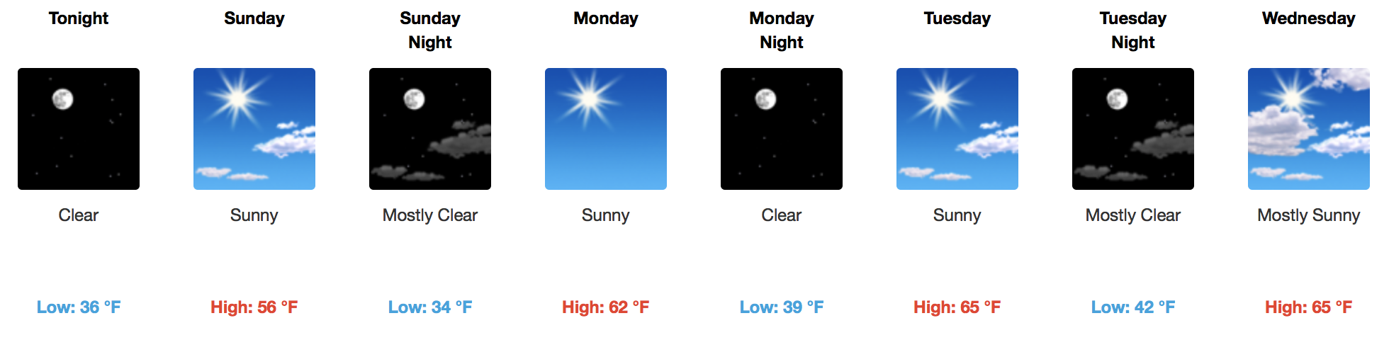
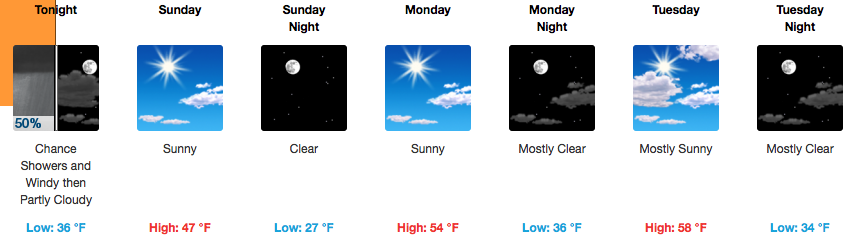
Dry Cold Front On the Way

WPC Surface Analysis

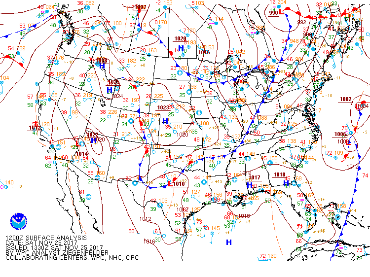
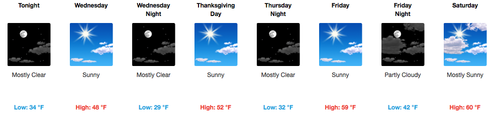
No rain with this one! The atmosphere is quite dry this morning over Middle Tennessee. Expect partly cloudy skies into the early afternoon, then clouds quickly clearing by evening. Temperatures will fall into the middle-lower 50s by 6pm, from a high of 63ºF around 3pm. read more

Quiet Forecast with Sunshine & a Dry Cold Front Passage Tomorrow

Somewhat Warmer Temps Continue, Dry Cold Front Passing Through Tomorrow

Black Friday shopping conditions look pretty great. Sunny skies with highs reaching into the low 60s.

https://giphy.com/gifs/nbc-thanksgiving-xUOxfgvoZWJo9CvTm8

Tonight into tomorrow, expect for a few more clouds than we’ve seen recently. A dry cold front will move through the area tomorrow, bringing somewhat cooler temps for Sunday. Full on sunshine will return then. read more

Clear Weather Ahead

Fluctuations in temperature this week have to do with which way the wind is blowing.

Colder north winds today will turn south tomorrow and Saturday and warm us up.

Saturday night another cold front arrives to turn the temp back down Sunday, but no rain is expected with the passage of the front. read more

Temperature Roller Coaster Continues, Thanksgiving Day Looks Great

Cooler Today & Tomorrow, Chilly Tonight

No rain chances for the foreseeable future and plenty of sunshine; sounds like a pretty good holiday week to me! Whether you are traveling today or any day through the weekend, Mother Nature will provide some fantastic road trip conditions. read more

Quiet Weather Pattern, Just Up and Down Temperatures Through Thanksgiving

Warmer Today, Much Colder Again Tomorrow. Roller Coaster Temps!

It is already 45ºF at the airport this morning, a good deal warmer than this time yesterday morning. Sunshine and a light south wind will bump our temperatures up nicely into the lower 60s this afternoon. read more

Cool Temps & Sunny Skies are in Control

Sunny & Dry Through the Week, Only Temperature Variations

This week looks to be pretty boring in terms of precipitation, with no real chances in the near future. Our local NWS started their morning forecast discussion with this:

Dry is the word of the forecast! There will be some upper level pattern changes over the next week, as well as some dry cold fronts, but otherwise not too much in the way of precip chances until middle of next week.” read more

Assessing Last Night’s Tornado Warnings...What Went Well, Not So Well, & Sirens.

Yesterday’s Tornadoes

What Went Well

The warning system did well for the “Gladeville” Tornado, because it showed itself on radar.

It was EF-1, winds 100 MPH.

Before the tornado formed, intense straight line winds swept ENE from Cane Ridge. read more

Chilly Temps Overnight, Sunny Skies Throughout the Week

Winds Calming Down Today, Rebounding Temps Tomorrow

Mostly sunny skies today with a few passing clouds. Winds have already begun to calm down from yesterday, but may still stay in the 10 mph range through the day. These winds will finally die off into the evening hours tonight. Luckily, with the cold air mass in place, our highs will stay in the 40s. read more

Windy and Cold Temperatures Rushing In

Wind Advisory In Effect

Storms Have Ended! Now, Wind and Cold.

Storms are done! Send us your remaining reports using #tSpotter.

Tonight, winds pick up and the cold rushes in. Gusts up to 35 mph are very possible and temperatures will drop FAST. Bundle up!! read more

Severe Thunderstorm Watch Until 7PM

Probabilities of Severe Weather Types