Current Official Hourly Observation (taken at :53 on the hour) & Radar


(Scroll down for The Editor’s “On Busted Forecasts” post).
Tonight – Clear & Cold – Midnight Temp 15

Current Official Hourly Observation (taken at :53 on the hour) & Radar
(Scroll down for The Editor’s “On Busted Forecasts” post).
Tonight – Clear & Cold – Midnight Temp 15
(Editor’s Note: Management does not condone The Intern’s controversial anti-snow title).
Current Official Hourly Observation (taken at :53 on the hour) & Radar
Tonight – Clouds Clearing – Midnight Temp 10
Current Official Hourly Observation (taken at :53 on the hour) & Radar
Tonight – *Wind Chill Advisory* – Mostly Cloudy; Cold & Windy – Midnight Temp 14
Wind chills tonight will be below 0. Winds will be strong: 15-20 mph, with gusts of 30 mph.
Current Official Hourly Observation (taken at :53 on the hour) & Radar
Today – That Was Fun – We Made It To 64!
9p 39 . Monday 12a 34
We exceeded this morning’s forecast high of 56.
Current Official Hourly Observation (taken at :53 on the hour) & Radar
Today – Sunny Morning/Afternoon, Windy & Mild, Clouds Tonight – Afternoon High 56
12p 48 . 3p 55 . 6p 54 . 9p 51 . Monday 12a 48
Current Official Hourly Observation (taken at :53 on the hour) & Radar
At 10 AM this morning, our streak of 95 consecutive below-freezing hours ended.
Tonight – Scattered Clouds – 9PM 31
Current Official Hourly Observation (taken at :53 on the hour) & Radar
Today – Early Morning sNOw Ending; Windy; Clearing This Afternoon – Afternoon High 44
9a 30 . 12p 38 . 3p 42 . 6p 36 . 9p 31
Current Official Hourly Observation (taken at :53 on the hour) & Radar
7:00 PM Update
Here’s the NWS Snowfall Accumulation Map:
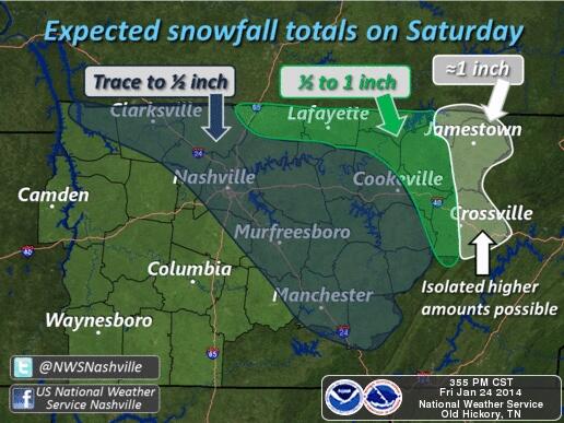
Here’s another look at the NWS forecast:
Current Official Hourly Observation (taken at :53 on the hour) & Radar

“Soup-er Cold.”
Because you’re gonna want to eat some “soup” to warm up!

(Editor’s Note: Honestly, I can’t think of anything better than The Intern’s soup joke. I would be a dead man had I made that pun during a guest appearance on the Andy Gibb Talk Show. For this I BLAME WINTER).
Current Official Hourly Observation (taken at :53 on the hour) & Radar
(Editor’s Note: The Intern comically titled this post “FREAKING COLD! Warmer Weekend, Then FREAKING COLD Again!” I’m not really sure why I edited it. I just…I don’t know. I’m just not feeling funny these days. Nothing seems to deserve an exclamation point anymore. I may have lost my sense of taste. These pretzels aren’t making me thirsty. People are sending me to my room. I’ve been wearing a lot of gray. And black….)