Two Rounds of Rain This Week with Flash Flooding Concerns

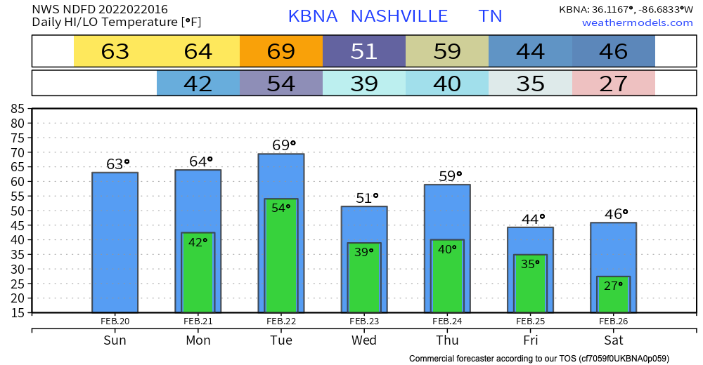
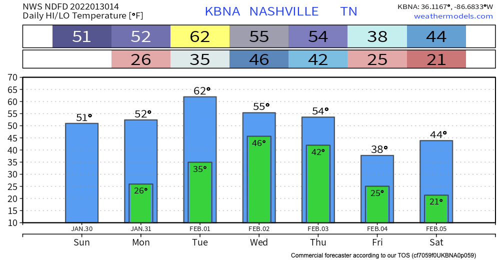
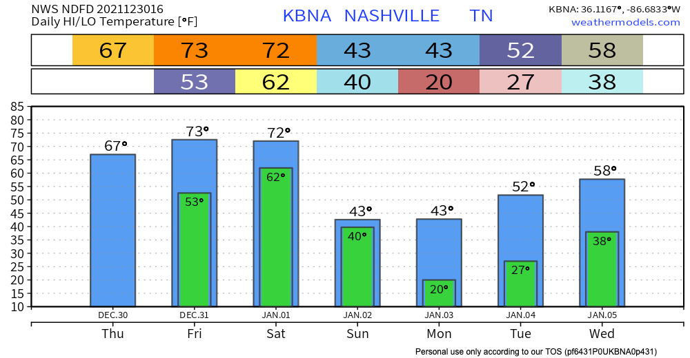
Today we hit the low 60’s jackpot, sunshine, and no rain. Great finish to the weekend.

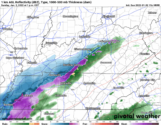
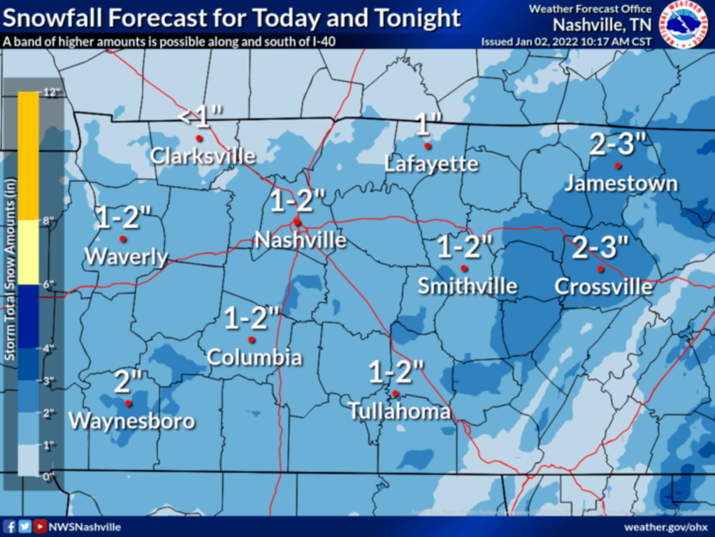
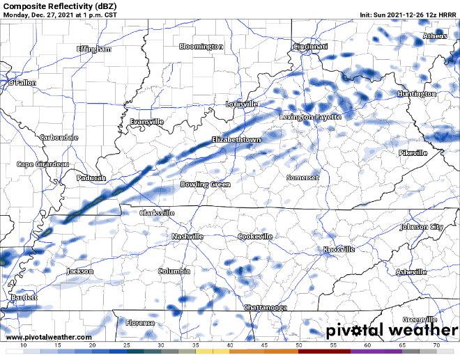
The rest of the week will not be this pretty. Get ready for rain.

The rain this week will come in two rounds: #1 Monday night through Tuesday night & #2 Wednesday night into Thursday night.

Round #1

The HRRR shows some showers and thunderstorms arriving Monday afternoon. This will be sparse and you may not get anything from these. As we get further into Monday night, the more rain there will be.

Here is what the GFS thinks is in store beginning Monday at 9 PM and continuing through the entire day Tuesday.

The GFS thinks 1.5″ to 3″ total:

This is consistent with the NWS-Nashville forecast:

The severe threat for Round #1 very low. The only category the SPC placed us in for this event is damaging wind. There is a 5% chance of damaging winds within 25 miles of you. See map below:

Flash flooding is the bigger concern Tuesday. 2″ to 3″ will rise local creeks and streams. If the rain is spread out long enough, we should be able to handle it. However, if we get a few “training” thunderstorms in here Tuesday, we should start to see flooding, and a narrow swath of the map may see more than 3″. The risk of flooding is “at least 15%” within 25 miles of you, but understand that risk is greatest for those in urban, and/or low-lying, and/or flood vulnerable spots. You know who you are.

Round #2 arrives Wednesday overnight into Thursday. The GFS model below shows what looks like rain along a warm front, then more rain as a cold front crosses:

Another 1.5″ to 3″ is expected.

Lower dewpoints reduce/eliminate any severe thunderstorm threat. But, the flooding threat remains. The ground will be pre-saturated meaning water will go where we don’t want it.

Plenty of weather to pay attention to this week, we’ll be sure to keep you posted

Quick References:

Weather changes constantly.
Follow @NashSevereWx on Twitter for any changes to this forecast.

Live coverage during tornado and severe thunderstorm warnings:

Look good.
Support the mission.

We are 100% community supported. No ads. No subscription fees. Keep it free for everyone.

Cold Today; Warmer Temps Midweek then Severe Weather Possible Thursday

This morning is cold. Wind chills were in the teens.

Temps top out around 40 today. Hopefully your Super Bowl plans are indoors.

Monday & Tuesday are the same deal as today, but with warmer temps. We’ll crack the 60’s on Tuesday. Those warmer temps will hang on until Thursday, then begin to fall again.

Thursday is the next day to put on your radar (pun fully intended). The SPC has us just in the zone where severe weather could happen in their day 5 outlook. This map below says there is a 15% chance of severe thunderstorm within 25 miles of any point in the yellow.

A day 5 and 6 outlook is not common, so I understand the stress some of you may be feeling as you read this. Try not to worry too much if you have storm anxiety. There is a lot of uncertainty still this far out. Today the outlook shifted a bit further south so we are now only barely included. The shift is because models yesterday pulled the low pressure center further south. The risk area shifted further south along with it.

This storm event looks like it will have sufficient wind shear, but insufficient instability. Right now, there is no reason to be overly concerned. There is no data telling us what kind of severe weather we might expect (hail, tornado, winds), but if there is no surface based instability it will be very difficult to make tornadoes.

Timing on this event looks to be from the very early hours Thursday until noon. The timing on this event is VERY iffy this far out.

Rain looks heavy and you should plan for a rainout Thursday, but flooding isn’t a big concern.

As we get closer to Thursday, we’ll have a better idea of how this event will play out. We’ll keep you posted!

“There is a lot of uncertainty about the details…stay tuned to the latest forecasts as we get closer in time.” –NWS-Nashville.

Quick References:

Weather changes constantly.
Follow @NashSevereWx on Twitter for any changes to this forecast.

Live coverage during tornado and severe thunderstorm warnings:

Look good.
Support the mission.

We are 100% community supported. No ads. No subscription fees. Keep it free for everyone.

Chilly Mornings & Dry Weather Ahead

This morning was chilly. Temps in the high 20’s. That early morning chill will be a common trend this week. Maybe not in the 20’s everyday, but 30’s at least. Don’t let any Northerner friends try to convince you this isn’t cold like the guy in the gif below.

nashville GIFs - Primo GIF - Latest Animated GIFs

Temps “warm” into the 40’s today. The trend for the next 7 days is cold mornings, less cold afternoons. Temps later in the week do get higher than today though. Talkin’ 50’s.

Rain is not a concern for the next 7 days. The NWS says so at least.

If anything changes we’ll keep you posted!

Quick References:

Weather changes constantly.
Follow @NashSevereWx on Twitter for any changes to this forecast.

Live coverage during tornado and severe thunderstorm warnings:

Look good.
Support the mission.

We are 100% community supported. No ads. No subscription fees. Keep it free for everyone.

Mid-Week Heavy Rain, Wintry Precip Potential Thursday

WARMER

High temps in the 30’s are a thing of the past. We should reach into the lower 50’s today.

Winter Go Away Sparkles GIF - Winter Go Away Winter Sparkles - Discover &  Share GIFs

HEAVY RAIN

Rain begins Wednesday and runs through most of the day Thursday. Here’s the GFS model:

It’s a lot of rain. Heaviest from Wednesday afternoon overnight into Thursday morning. We can probably handle 3″ to 4″ of rain if we can spread it out over 24+ hours. So not overly worried about flooding but it is a low key concern, something to watch starting Monday night when the higher res models get a look at it.

WINTRY PRECIP

Our warm, wet earth will get suddenly cold Thursday late afternoon/night as the precip moves east. But will we get cold enough? The Euro thinks we could see wintry mix/sleet, or even snow (see below).

Models disagree. If the big red L goes further north it means only rain for us. If the big red L goes further south we’ll be on the cold side and can get some wintry precip or snow. Sunday model resolution for Thursday is poor, but the pattern puts travel interruption potential on the table late Thursday. Here’s a model comparison GIF of four models indicating the general pattern suggestive of a rain to sleet/snow event.

There is no sense of accumulation in this data. The earth will be warm and wet and the wind will be howling. Could see anything from a Just Rain or low-output wintry precip splat:melt event (low end) to an accumulating smorgasbord of ice/snow (high end). Typically snow fans end up disappointed but if we get a robust red L running to our south and southeast, yet another snowmess is possible. Three of the four models above have the low in the general area favorable for wintry precip, but these models have been inconsistent and have a poor track record predicting local events/timing.

More tomorrow.

Quick References:

Weather changes constantly.
Follow @NashSevereWx on Twitter for any changes to this forecast.

Live coverage during tornado and severe thunderstorm warnings:

Look good.
Support the mission.

We are 100% community supported. No ads. No subscription fees. Keep it free for everyone.

Chilly and Dry Weekend Ahead

All the wintry stuff is well east of us by the time you are reading this. Now we are just left with the cold.

It is COLD out. The high temp today is expected to get up to freezing. If you take wind chill into account it’ll feel like it’s in the teens. The extremely blue and purple image below better illustrates this.

No precipitation is expected so that means no snow.

The cold is here to stay through the weekend.. Friday temps still don’t climb above freezing. Saturday gets slightly above it but still very cold. Sunday we “warm” into the 40’s. Dry weather expected all weekend.

The Sopranos GIF - The Sopranos Paulie - Discover & Share GIFs

Next chance of rain looks to be overnight Monday into Tuesday. Just rain, nothing major. More on the timing of this event as we get closer

Quick References:

Weather changes constantly.
Follow @NashSevereWx on Twitter for any changes to this forecast.

Live coverage during tornado and severe thunderstorm warnings:

Look good.
Support the mission.

We are 100% community supported. No ads. No subscription fees. Keep it free for everyone.

Snow Tomorrow & Potential Travel Issues

Last month seemed like never ending severe weather. This month seems like never ending winter weather.

Today’s weather is pretty plain and simple. Slightly warmer temps, a little breezy, and no rain. Now on to the fun stuff.

Temperatures drop overnight tonight into the mid-20s. Precipitation is expected to get to us around 7 AM. Since it’s below freezing, we will see snow again.

HRRR has the snow arriving around 7 AM and leaving around lunch time. See visual below:

Notice we are primarily in the blue, not the pink or purple. Blue is snow. Pink and Purple is freezing rain and ice. Ice is expected to be south of us. Here is where the NWS thinks the ice and sleet will occur.

This image has an empty alt attribute; its file name is Screen-Shot-2022-01-05-at-2.38.37-PM-1024x571.png

There is a slight chance the counties just above this purple region could see some ice and sleet. (looking at you Williamson Co.)

Snowfall totals for this event look like they will be in the 2″ – 3″ range. The ground will be cold enough for accumulation to occur, so it’s not a question of if it sticks but rather how much snow will fall as opposed to sleet or freezing rain. Note that model confidence is “medium and increasing”. We’ll update you on any important changes should they happen.

After all the snow falls, what happens to temps? They PLUNGE. We’ll be in the teens by Thursday night, and close to 10 degrees by Friday morning.

This means snow cover from Thursday is not going anywhere, and any standing water or wet areas will freeze. This all leads to dangerous road conditions.

Expect hazardous road conditions Thursday, and probably all day Friday because we never get above freezing, especially on untreated roads. Saturday temps will hit 50 degrees so this should take care of any ice or snow.

Forecasts are always subject to change. How could this one change you might ask? The NWS has an awesome slide to answer that question.

We’ll keep you posted on this event on twitter and here!

Quick References:

Weather changes constantly.
Follow @NashSevereWx on Twitter for any changes to this forecast.

Live coverage during tornado and severe thunderstorm warnings:

Look good.
Support the mission.

We are 100% community supported. No ads. No subscription fees. Keep it free for everyone.

Snow Forecast Was For Less Than 1″, Now 1″ to 2″

Snow is coming.

The latest HRRR model run delivers snow earlier than the earlier 4-6 PM timeline. It thinks the wintry stuff could be here as early as 1 or 2 PM. See below:

This image has an empty alt attribute; its file name is floop-hrrr-2022010215.ref1km_ptype.us_state_ky_tn.gif

Expect the first hour or so of snow to melt on contact. The ground is very warm. But heavy snowfall rates should supercool everything, and eventually allow for the snow to stick to all surfaces. NWS-Nashville increased snow totals.

They wrote this in their 11 AM discussion:

WILL LIKELY SEE A SLOW CHANGEOVER THIS AFTERNOON WEST, BECOME ALL SNOW THIS EVENING. SNOW AMOUNT FORECAST VARIES GREATLY. SEVERAL MODELS SHOWING VERY HIGH BULLSEYES HERE AND THERE BUT CURRENTLY THINKING IS MOST AREAS WEST OF THE PLATEAU 1-2 INCHES, 2-3 INCHES ON THE PLATEAU. THESE AMOUNTS ARE LIKELY ON GRASSY, EXPOSED SURFACES. ROADS QUITE WARM AND MUCH WILL MELT WHILE FALLING. ELEVATED SURFACES MAY BECOME SLICK TONIGHT, AND FOR THE MORNING COMMUTE. THUS UPPED AMOUNTS JUST SLIGHTLY FOR TODAY

Now 1″ to 2″ for us, up from the forecast of less than an inch earlier today.

This image has an empty alt attribute; its file name is Screen-Shot-2022-01-02-at-12.02.43-PM-1024x769.png

Bridges and overpasses will be the first road surfaces to become slippery.

There is no way to know exactly when specific roads, runways, interstates, etc. will become slippery because our transport grid runs at varying elevations and temps and are subject to different physical properties that determine when and whether ice can form. Our local temps can vary by several degrees.

Expecting temps near freezing at BNA closer to midnight, but BNA usually runs hot so expect the potential for travel impacts to begin before midnight. The later we get in the day, the higher the risk of slippery roads. By/Before midnight, everyone should be below freezing and by early Monday morning we’ll be in the mid 20°s at which time anything still wet will freeze.

Snowfall total predictions have increased since earlier this morning. NWS thinks we could see anywhere from 1 – 2″. This will make traveling not so fun, especially for first time snow drivers. Use caution and maybe avoid totally if possible. The freezing temps Monday morning mentioned before will allow snow and slick conditions to hang around in the AM.

Snowfall totals depend on many things, most of all they depend on the track of the upper level low that’ll be passing to our southeast. This thing:

This image has an empty alt attribute; its file name is image-9.png

Gusty winds will also help dry roads. That’ll come with a cost: wind chills in the teens Monday morning.

All this adds up to the Winter Weather Advisory in effect from 3 PM Sunday to 3 AM Monday.

More through the day, night, and overnight can be found on our Twitter.

Snow Forecast Up from < 1", Now 1" to 2"

Snow is coming.

The latest HRRR model run delivers snow earlier than the earlier 4-6 PM timeline. It thinks the wintry stuff could be here as early as 1 or 2 PM. See below:

Expect the first hour or so of snow to melt on contact. The ground is very warm. But heavy snowfall rates should supercool everything, and eventually allow for the snow to stick to all surfaces. NWS-Nashville increased snow totals.

They wrote this in their 11 AM discussion:

WILL LIKELY SEE A SLOW CHANGEOVER THIS AFTERNOON WEST, BECOME ALL SNOW THIS EVENING. SNOW AMOUNT FORECAST VARIES GREATLY. SEVERAL MODELS SHOWING VERY HIGH BULLSEYES HERE AND THERE BUT CURRENTLY THINKING IS MOST AREAS WEST OF THE PLATEAU 1-2 INCHES, 2-3 INCHES ON THE PLATEAU. THESE AMOUNTS ARE LIKELY ON GRASSY, EXPOSED SURFACES. ROADS QUITE WARM AND MUCH WILL MELT WHILE FALLING. ELEVATED SURFACES MAY BECOME SLICK TONIGHT, AND FOR THE MORNING COMMUTE. THUS UPPED AMOUNTS JUST SLIGHTLY FOR TODAY

Now 1″ to 2″ for us, up from less than an inch earlier today.

Remember that bridges and overpasses will be the first road surfaces to become slippery.

There is no way to know exactly when specific roads, runways, interstates, etc. will become slippery because our transport grid runs at varying elevations and temps and are subject to different physical properties that determine when and whether ice can form. Our local temps can vary by several degrees.

Expecting temps near freezing at BNA closer to midnight, but BNA usually runs hot so expect the potential for travel impacts to begin before midnight. The later we get in the day, the higher the risk of slippery roads. By/Before midnight, everyone should be below freezing and by early Monday morning we’ll be in the mid 20°s at which time anything still wet will freeze.

Snowfall total predictions have increased since earlier this morning. NWS thinks we could see anywhere from 1 – 2″. This will make traveling not so fun, especially for first time snow drivers. Use caution and maybe avoid totally if possible. The freezing temps Monday morning mentioned before will allow snow and slick conditions to hang around in the AM.

Snowfall totals depend on many things, most of all they depend on the track of the upper level low that’ll be passing to our southeast. This thing:

Long ago Paul Heggen taught me: always look for the 700mb low.

Gusty winds will also help dry roads. That’ll come with a cost: wind chills in the teens Monday morning.

All this adds up to the Winter Weather Advisory in effect from 3 PM Sunday to 3 AM Monday.

More through the day, night, and overnight can be found on our Twitter.

Calm Weather Today and Most of Tomorrow; Severe Weather Possible NYE and NYD

No rain for us today. We got that out of our system yesterday. There is plenty more on the way though. Let’s talk about that.

New Year’s Eve looks dry for the most part, until we get to the evening. This is probably preferred on any day of the year except NYE. The weather wants to party, too.

HRRR has showers and storms getting to us around 10 PM and hanging around into the early hours of Saturday. The rain looks like it slowly moves north, so we could see a break from it in the morning. See below:

The million dollar question is will these storms be severe? The answer is severe weather is possible. The SPC has us on the fringe of where they think the best chance for severe weather will occur. See below:

Severe hazards ranging from tornadoes, damaging winds, and hail are a potential risk. SPC thinks the chances for these hazards within 25 miles of you are 5%, 15%, and 15% respectively.

Don’t let this send you into a panic for NYE. Be weather aware and have a plan just in case.

2021 is over so severe weather is too… right?

Not so fast. 2022 will start off with the another chance of severe weather. The SPC outlook below indicates there is a 15% chance of severe weather within 25 miles of you Saturday. The percentage breakdown of tornado, damaging winds, and hail isn’t available yet, so this graphic says there is a 15% chance of at least 1 of those happening, not all 3.

CAPE values (storm fuel) for this event don’t look too high. Shear values are more impressive. This could lead to a storm rotating and producing a brief tornado. Damaging straight line winds and gusts are more likely.

The line of storms that will be responsible for this event arrives early evening Saturday. The Euro and GFS agree on timing. See below:

Euro
GFS

Between Friday and Saturday’s events, Saturday looks like it would pack a bigger punch. Best advice is have a way to receive warnings both days, especially if you have holiday plans.

Besides the severe threat, Saturday’s event is going to bring a lot of rain. The SPC graphic below indicates a 10%-20% chance of flash flooding within 25 miles of you.

Models had previously estimated up to 3 inches of rain by Sunday. This number has back down a bit to around 1.5 – 2 inches. Confidence on this number will increase as we get closer.

Severe threats have passed, now what?

Colder temps are back. Cold air behind the gross weather will fill in and temps get back into the 30’s on Sunday.

There is a chance for light snow Sunday afternoon. Nothing crazy, but you could see some flurries. Hard 180° from last week’s weather.

Winter Winter Is Coming GIF - Winter Winter Is Coming Lets Sell Your Home -  Discover & Share GIFs

We’ll keep you updated on the severe threats over this holiday weekend!

Rain on the Way

No rain today.

Rain chances increase Monday and Tuesday. HRRR shows spotty showers Monday afternoon and evening. Looks like on & off rain rather than a steady one. Nothing to worry about.

Tuesday’s rain chances look better, especially Tuesday night. Our first weather maker of the week will bring more steady rain Tuesday night into Wednesday. See HRRR below:

Wednesday is looking pretty meh. Lots of rain and possible storms. Instability over us looks pretty weak, so severe threat is minimal. SPC thinks any severe weather will occur south of us. We’ll keep you posted on this event.

Another weather maker comes through this weekend in the form of a cold front, ETA looks like Saturday. The Euro and GFS can’t seem to agree on a time for this yet, but Saturday is looking wet. New Year’s Eve looks dry for now.