
Warning: Weather models aren’t very good at handling summertime thunderstorms.
Summer storms are very hard to predict, but as a general rule: rain and storms are mostly likely to develop between mid/late afternoon and early evening.

Warning: Weather models aren’t very good at handling summertime thunderstorms.
Summer storms are very hard to predict, but as a general rule: rain and storms are mostly likely to develop between mid/late afternoon and early evening.

There are times weather models can see what’s coming so we can provide you a good, reasonably reliable (not perfect), “when and where.”
This is not one of those times.
Weather models, which in a perfect world should arrive at the same thing, predict different things. Weather models also aren’t very good at handling summertime thunderstorms.
A repeat of Sunday, temp and humidity-wise.
We wrote about it this morning, and this afternoon’s model runs still have it: a quick-passing tuft of rain moving thru in the morning. Here’s the NAM3 model:

83°, with the dewpoint in the low 50°s. Low fifties! It’s like it’s not even summer!
Low 80°s temps, and as far from summertime humidity as we can get.
Very light rain may sneak in from Arkansas and Missouri Tuesday morning, but it looks pretty iffy. The GFS model shows only a sprinkle passing through Tuesday morning:
More rain, with maybe a little lightning, is on the way tonight.
Flash flooding (a flood that happens almost suddenly, due to heavy rain and run off) is tonight’s primary weather concern.
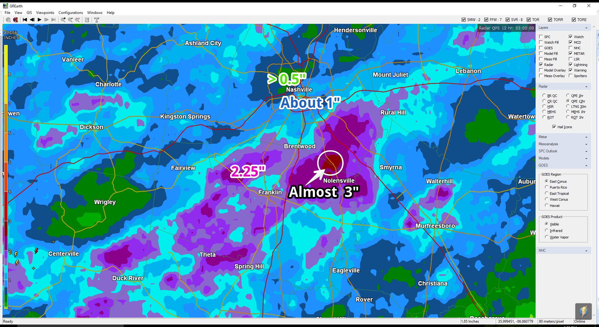
A lot of rain has fallen. The below map is a radar estimate as of 6 PM. The purple indicates radar estimates of 1.5″ to 2″ or more, and are especially vulnerable to flash flooding tonight/overnight.

This afternoon’s storms produced a few downed trees and limbs, and some localized flooding. Those storms have departed south and east down I-24.
From around 4 PM to 6 PM, the rain should switch “off.” The HRRR model predicts more rain beginning around (maybe before?) 7 PM, and continuing for at least a few more hours.

Today’s Father’s Day forecast is kinda like this.
Expect thunderstorms.
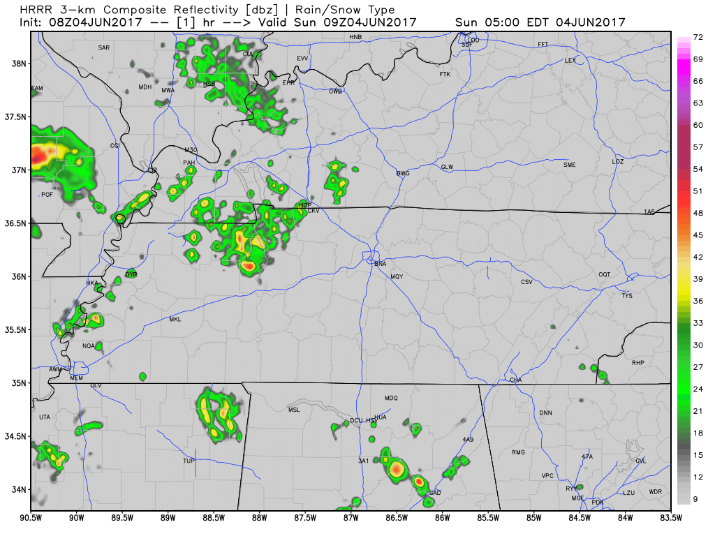
At 8:45 AM, weak storms near Paducah, KY, are moving slowly our way down I-24. Those storms should strengthen as they approach and encounter a hotter, more destabilized airmass here in Davidson & Williamson Counties.
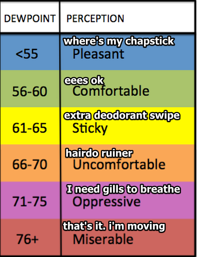
Humidity increases tonight. The dewpoint will rise past past 65° around 7 PM and settle in around 67° by 10 PM, which will be more humid than it’s been all week. Even though the temp will drop into the 70°s by 10 PM, those of you outside will be looking for water. It’ll be that humid.
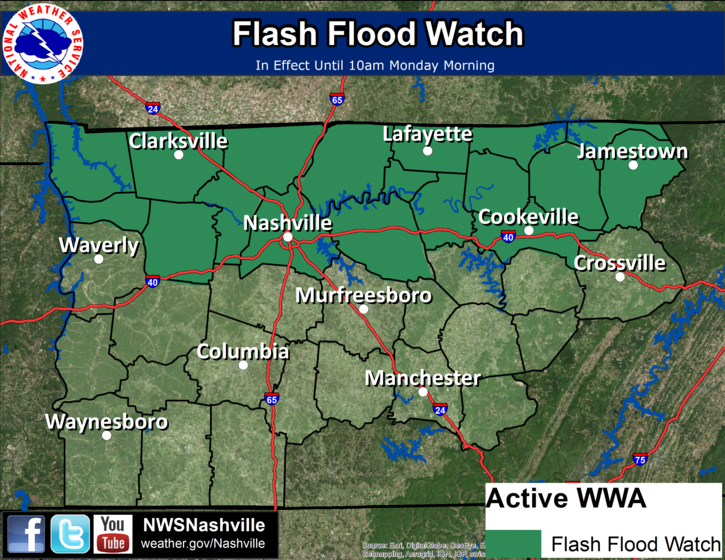
Our NWS has their eye on the possibility of training thunderstorms overnight. So, they’ve issued this watch. We’ll keep an eye on it as well.
Thru 3:30 PM, radar estimates 1″ of rain has fallen (in yellow, below), mostly in Williamson County:
This morning, NWS-Nashville wrote “Today through late Monday…the mid-state expected to remain in deep moisture regime…with a series of upper impulses passing …and with a few weak low-level boundaries in the immediate vicinity.”
You must be logged in to post a comment.