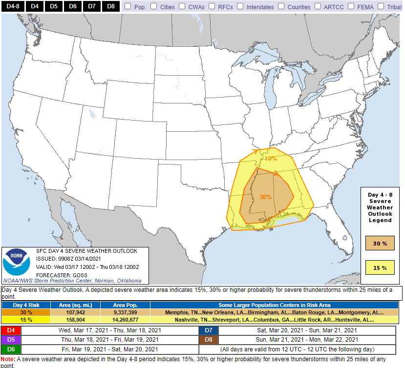
18z model runs (six of them, below) depict Wednesday’s severe event southwest of – but not including – Davidson and Williamson Counties:
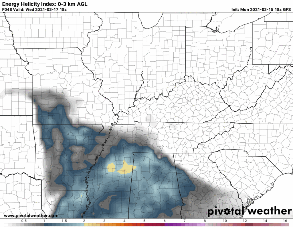
This aligns with the 15% severe threat for Wednesday from the Storm Prediction Center.

18z model runs (six of them, below) depict Wednesday’s severe event southwest of – but not including – Davidson and Williamson Counties:
This aligns with the 15% severe threat for Wednesday from the Storm Prediction Center.
Substantial wind shear will be in place as a line of storms approaches Monday morning. ETA late morning/lunch. But instability should be near zero, reducing if not eliminating most/all severe storm concerns. Winds may still be strong (40 MPH or so) — and we cannot totally rule out a severe wind event — but there is no reason for a hail or tornado concern Monday.

The supercell appeared on radar a year ago tonight. By 12:33 AM Tuesday March 3, 2020, that [expletive deleted] was here. You know what happened.
I was behind screens watching radar, data, internal chat, typing furiously in surreal horror. Since then I’ve watched and read everything I could find about that tornado. I’ve been back through the radar data. I’ve reviewed the meteorology. I’ve reviewed every tweet I sent and every frame of video footage I could find. I’ve looked at, and walked in, stood in and looked up through, your damage. Many, many times. Trying to process it, to understand it, to be better. I’ve even written a retrospective.
By the time the storm line got to us tonight, low level winds were running parallel to storm motion. Add an inversion aloft with a heavily saturated column. The trio wrecked our low-probability tornado chances.
Ice missiles fly off the tops of cars and truck and onto the windshields of cars and trucks behind them. These are this weekend’s biggest hazard. Sometimes the ice doesn’t missile backwards causing property damage or an accident. Sometimes it slides forward and covers your windshield while you are driving. Clear the top of you car and truck before going out.
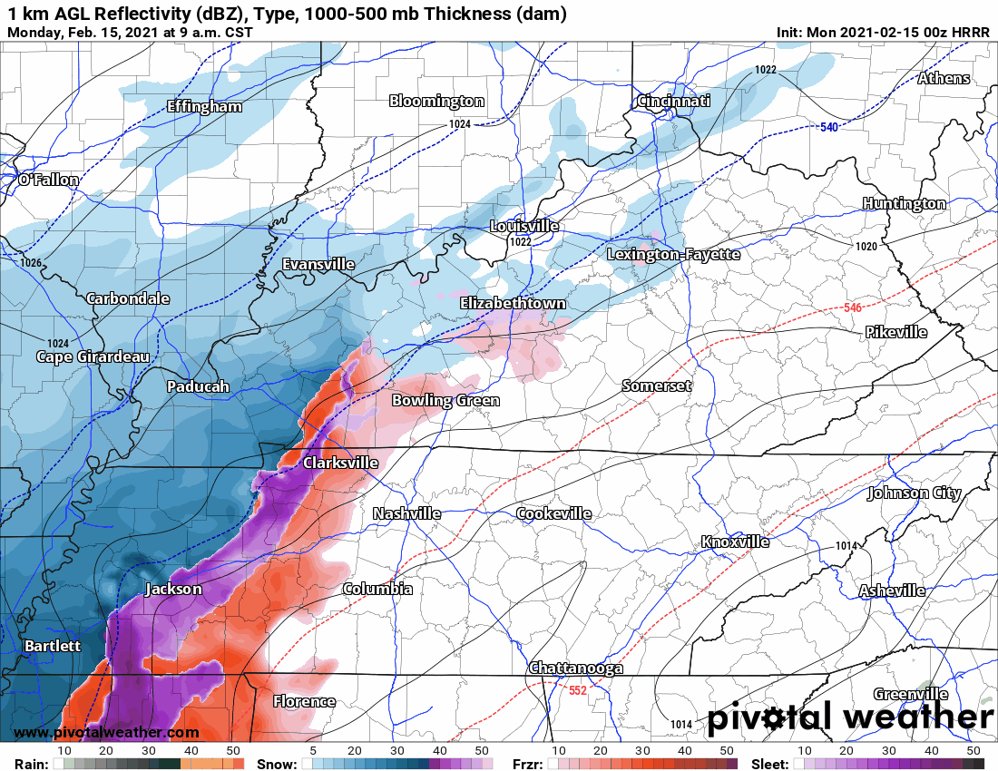
The 18z HRRR model run thinks snow will pass north of us Wednesday morning. By sundown Wednesday night, we begin several hours of snow ending around 1 AM Thursday morning. Then a pause until sunrise, when a sleet/snow event begins then transitions quickly back to snow and continues at least through noon Thursday. Then the model cuts off.
First a personal note. I put on a guy on blast on Twitter this afternoon. I shouldn’t have. I got frustrated because I thought his criticism was unfair, and for a minute I thought I was in court. Those who disagree with me or don’t like the way we do things nevertheless deserve my respect. Dragging anyone’s tweet out in front of our audience out of anger and revenge in order to shame them to try and win an argument is not cool. What I did was, and is, wrong. Twitter feuds drive a wedge between us, no minds change, we all just end up angry. I apologized to him (to his credit, he was the bigger man and reached out to me first). The truth is my pride in what we built made me a jerk. I should always be kind. I’ve been given grace, and I did not return it. David.
Roads, steps, decks, and sidewalks coated with black ice this morning and this afternoon are dealing with a heavy coat of sleet tonight. Travel is dangerous. Do not try it. 4WD may provide traction, but it cannot assist your stop.
“This is an evolving forecast that will likely change over the next 24-36 hours.” –NWS-Nashville.
Saturday night – Sunday morning, there may still be lingering slick spots on bridges and overpasses. Drizzle on windshields means black ice on roads.
Until 10 AM this morning (Saturday) a Winter Weather Advisory warns of freezing fog, freezing drizzle, and a few patches of light freezing rain laying down “ice accumulations of a light glaze.”
You must be logged in to post a comment.