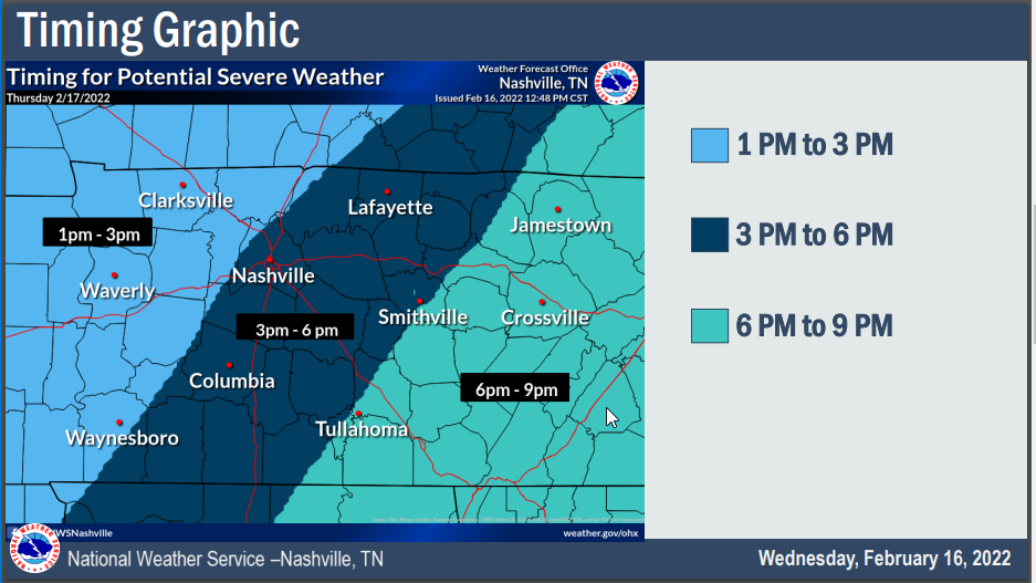
Tonight’s 0z run of the HRRR model thinks beginning Tuesday after lunch an atmosphere somewhat capable of producing a tornado or two, damaging straight line winds, and maybe even hail will settle in. The severe storm capability should linger into the evening and end before bedtime if current model data has it right.
Author: David
I’m concerned about flooding next week.
Evening Update on Tornado/Wind Concerns Thursday
Blergy Today. & About Rain/Storms Thursday. Severe? Ehhhh, maybe?
Blerg today.
We got to talk blerg today. Blerg means no snow, no sun, temps under 40°. I issued a Blerg Watch today (conditions favorable for blerg) but not a Blerg Alert (blerg in progress) because we may see a few flakes this afternoon, the sun may show up briefly this afternoon, and some of us may actually hit 40°.
Few Flurries Possible Tuesday Morning, No Worries
A few flurries are possible Tuesday morning. You can see them at the end of the 12z HRRR model run.

I’ll tweet the 18z run when it comes out in a few hours. Think these will be inconsequential if they happen at all — the precip isn’t on other models. Surface temps should be at least 3° (probably more) above freezing. Splat:Melt. No party, no worries.
Transition to Snow, Variable Accumulation, Freezing/Travel Hazards Tonight/Overnight
Slightly Warmer Surface Temps Have Entered The Chat. Winter Storm Warning Update on Highly Variable Forecast.
Winter Storm Watch Saturday Night to Sunday Night, Fresh Deets
an essay on the “probably a snowstorm” coming our way this weekend
on presnow days like this I spend a few hours looking at models and reading forecast discussions. i do one other thing, and that’s trying to keep my brain brew cold, which means i’ll spend 15 minutes beating up my somehow iced over fridge icemaker, picking up the ice pieces that fall on the floor from all the pounding. i don’t mind admitting to you that when i am beating up the machine i am sometimes definitely cursing at it. the forecast and the ice machine are a mess.
Sunday Snow Because Why Not
NEW YEAR’S DAY RECAP
Instability (not enough) – shear (way too much) combo was off today. Storms rotated and we had cause for the one tornado warning in west Williamson County, but by the time that storm got to the Will Co line it lost concerning tight rotation. We think Ned’s cap hung on just long to keep storms from exploding over 20kft, so we escaped New Year’s Day unscathed.