Deck Sealers Rejoice for “Moderate Drought”

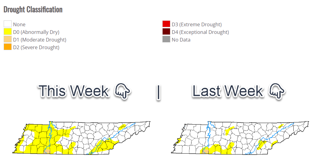
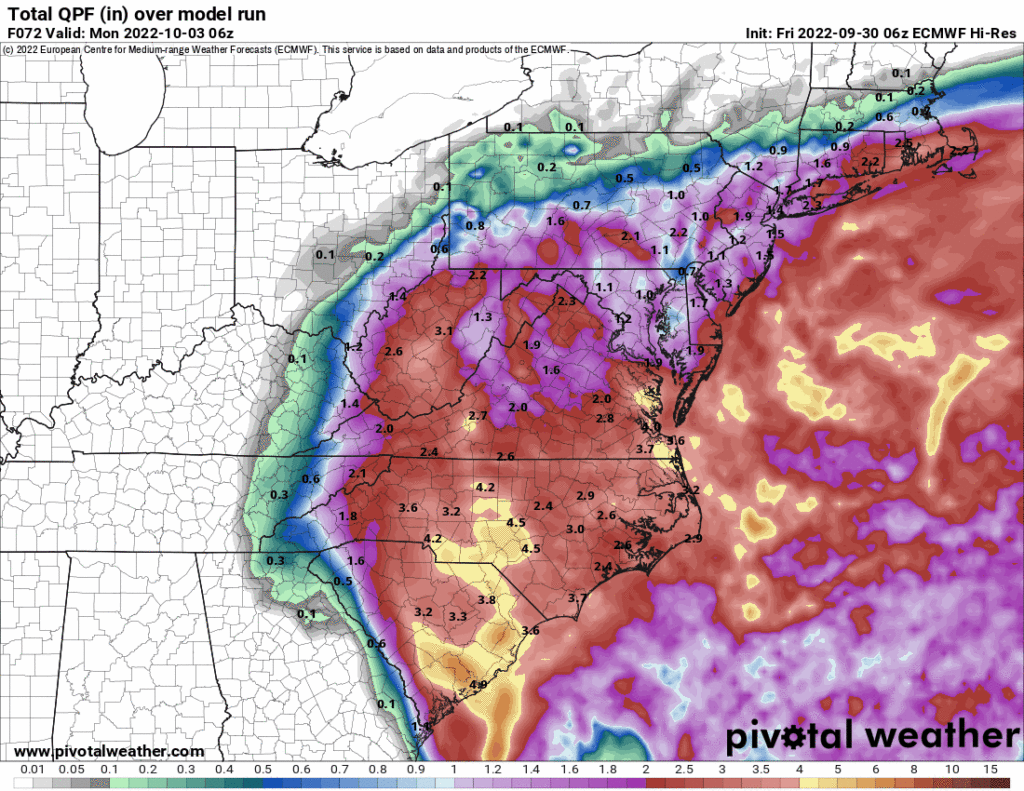
We are all “abnormally dry.”

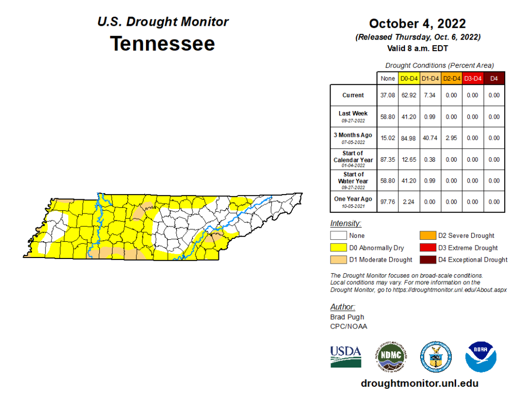
  • Even worse: most of Nashville is in a moderate drought.

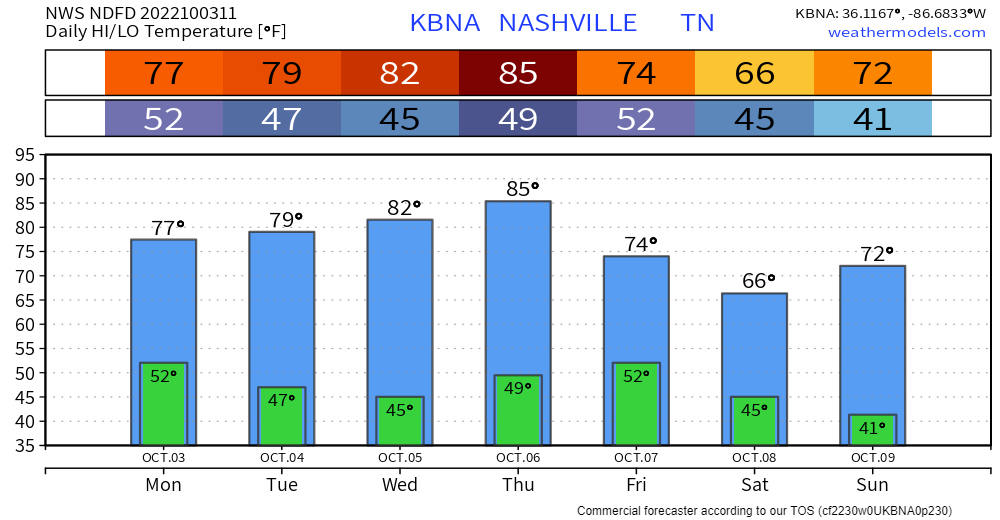
You know how it happened:

  • Our last rain of more than a tenth of an inch was 0.44″ on September 11.
  • We average 3.80″ from Sept 1 to Oct 6. This year we’ve had 1.43″, almost all of which came the first two weeks of Sept.

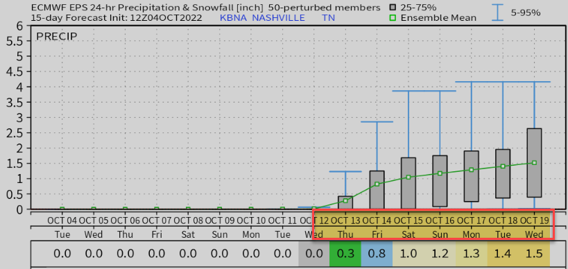
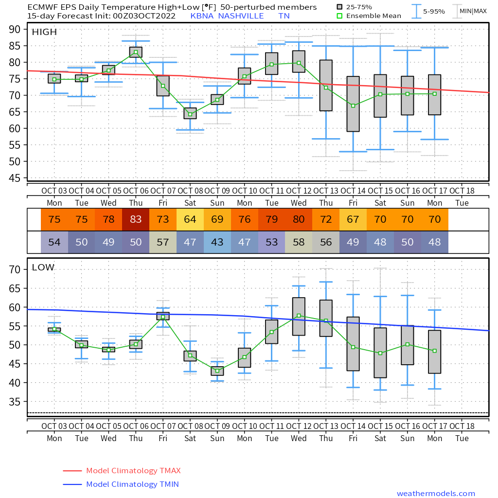
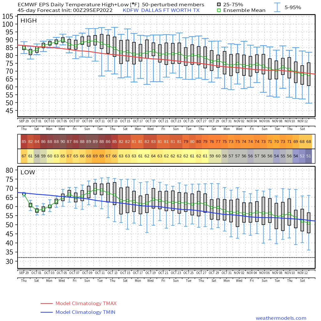
Not even a chance of rain until maybe late Wednesday, Oct. 12. Low confidence in that.

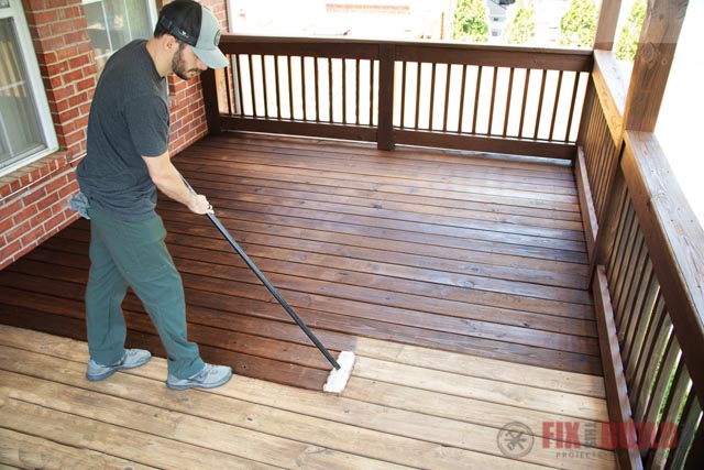
It’s a great time to seal your driveway or stain your deck. read more

Wait another week or so for rain.

No rain until maybe the Thursday the 13th:

This is Euro ensemble model data

Many of us will dip into the upper 30°s around sunrise weekend.

  • Frost should miss us to the east, up on the plateau.
  • You’ll want your heater tho.

Alert tweeter Justin side-eyed Tuesday’s crap app forecast: 38° in the morning to 97° in the afternoon, guh. read more

Elevated Afternoon Fire Danger

  • Don’t burn stuff this afternoon.
  • afternoon relative humidity 10% to 20%, that’s crazy dry
  • brown ground getting crunchy
  • thankfully winds should be under 10 MPH, but still …

… no significant rain has fallen in Middle Tennessee since September 11 and our area has become quite dry – so elevated fire danger is expected during the afternoon hours with a risk for brush fires. read more

Hot then cold, sorry but no rain

Mid week warm up incoming, then much colder this week.

  • Upper 80°s Thursday in some models.
  • Cold front arrives Thursday night.
  • Much colder weekend mornings.
  • Some us of will see upper 30°s before sunrise Sunday morning.

Euro shows several colder than normal mornings over the next two weeks:

Euro and GFS models show no rain chances until on/after October 13.

  • At least some fire danger remains
  • Especially tomorrow as relative humidity drops more.

Quick References: read more

The browns are in town.

Aerating and seeding? The only water you’ll get will have to come out of your hose.

Need to burn a pile? Not a good idea. If you must, avoid the afternoons, when relative humidity is lowest and winds are strongest. read more

No Rain In Sight, so a few words and graphs about fall temps.

Ian is over there 👉🏽

Ian’s rain is all going east of us this weekend:

No rain in sight.

  • Models show a front next Thursday bringing us no rain.
  • No surprise, October is our driest month.

Our average first fall freeze is November 1.

  • Euro ensemble model 👇🏽 shows temps mostly above average until the second week of … November.
  • CPC guidance 👇🏽 thinks above normal average temps (there will be cold snaps) through December:

This is not ideal. So-called “Secondary Storm Season” begins in November. read more

Ian Unlikely To Bring Weekend Rain

Little windy today, no big deal. Locate chapstick: low 40°s dewpoints.

Ian should be a tropical depression in mountains of east NC Saturday afternoon.

Probably too far east to bring us rain this weekend. read more

Ian Rain This Weekend?

Marginal fire danger today. Gusty winds and low relative humidity may spread outdoor fires. So maybe don’t burn things today.

All eyes on Ian in Florida.

Ian won’t bring us wind, tornadoes, or flooding. Right now it looks like it might not bring us rain. read more

Chilly therefore chili. Update on Ian-related weekend rain potential.

Morning jackets needed with lows in the 40°s. Roof frost is appearing in locations that often get way colder than the official BNA low.

Warmer this weekend as Ian moves inland.

Ian

Ian will become a major hurricane as it approaches Sarasota/City of Tampa midweek. We are not a landfalling hurricane source so follow @NHC_Atlantic and noaa.gov/ian for the latest forecasts. read more

2 Things: Maybe Don’t Burn Things. Will 🌀 Ian Bring Us Weekend Rain?

Brushfires could spread.

  • Low relative humidity and winds 10 to 15 MPH expected today and tomorrow.
  • These conditions can spread fires, especially where little rain has fallen lately.
  • But the concern is low.
  • NWS-Nashville is monitoring. They have not issued any warnings (called Red Flag Warnings). Winds aren’t quite strong enough to raise serious concerns. And it may not be dry enough.
  • We will update you on Twitter if this changes.

Locate your morning jacket, fam.

Ian’s after-landfall, inland path is unknown. One set of models brings its remnants into Middle Tennessee this weekend. Rain the only impact. read more